
Indiana facts for kids
Quick facts for kids
Indiana
|
|||
|---|---|---|---|
|
|||
| Nickname(s):
"The Hoosier State"
|
|||
| Motto(s):
"Crossroads of America"
|
|||
| Anthem: "On the Banks of the Wabash, Far Away" |
|||

Location of Indiana within the United States
|
|||
| Country | United States | ||
| Before statehood | Indiana Territory | ||
| Admitted to the Union | December 11, 1816 (19th) | ||
| Capital (and largest city) |
Indianapolis | ||
| Largest county or equivalent | Marion | ||
| Largest metro and urban areas | Indianapolis | ||
| Legislature | General Assembly | ||
| • Upper house | Indiana Senate | ||
| • Lower house | Indiana House of Representatives | ||
| Judiciary | Indiana Supreme Court | ||
| U.S. senators |
|
||
| U.S. House delegation |
|
||
| Area | |||
| • Total | 36,418 sq mi (94,321 km2) | ||
| • Land | 35,868 sq mi (92,897 km2) | ||
| • Water | 550 sq mi (1,424 km2) 1.5% | ||
| Area rank | 38th | ||
| Dimensions | |||
| • Length | 278 mi (432 km) | ||
| • Width | 149 mi (232 km) | ||
| Elevation | 700 ft (210 m) | ||
| Highest elevation | 1,257 ft (383 m) | ||
| Lowest elevation
(Confluence of Ohio River and Wabash River)
|
320 ft (97 m) | ||
| Population
(2024)
|
|||
| • Total | |||
| • Rank | 17th | ||
| • Density | 189/sq mi (73.1/km2) | ||
| • Density rank | 17th | ||
| • Median household income | $69,500 (2023) | ||
| • Income rank | 37th | ||
| Demonym(s) | Hoosier | ||
| Language | |||
| • Official language | English | ||
| Time zones | |||
| 80 counties | UTC−05:00 (Eastern) | ||
| • Summer (DST) | UTC−04:00 (EDT) | ||
| 12 counties | UTC−06:00 (Central) | ||
| • Summer (DST) | UTC−05:00 (CDT) | ||
| USPS abbreviation |
IN
|
||
| ISO 3166 code | US-IN | ||
| Traditional abbreviation | Ind. | ||
| Latitude | 37° 46′ N to 41° 46′ N | ||
| Longitude | 84° 47′ W to 88° 6′ W | ||


| Bird | Northern cardinal (Cardinalis cardinalis) |
|---|---|
| Flower | Peony (Paeonia) |
| Tree | Tulip tree (Liriodendron tulipifera) |
| Insect | Say's firefly (Pyractomena angulata) |
Indiana is a state in the Midwestern United States. It borders Lake Michigan to the northwest and Michigan to the north. To the east is Ohio, and to the south and southeast are the Ohio River and Kentucky. The Wabash River and Illinois are to the west. Indiana is known as "the Hoosier State". It is the 38th largest state by area and the 17th most populated. Its capital and largest city is Indianapolis. Indiana became the 19th state on December 11, 1816.
After the American Civil War, Indiana's northern counties grew with factories. Many new people from Europe moved there for jobs. In the early 1900s, the state became important for making cars. Southern Indiana stayed mostly rural. Today, Indiana is often called a "Red state" because it usually votes for the Republican Party.
Indiana has a strong and varied economy. In 2023, its total economic output was $404.3 billion. Indianapolis is the center of the state's biggest city area, with over two million people. The Fort Wayne area is next, with about 645,000 people.
Indiana is home to professional sports teams. These include the NFL's Indianapolis Colts and the NBA's Indiana Pacers. The state also hosts famous events like the Indianapolis 500 car race. This race happens at the Indianapolis Motor Speedway.
Contents
What's in a Name?
Indiana's name means "Land of the Indians". It also comes from the state's early history as a territory. On May 7, 1800, the U.S. Congress divided the Northwest Territory. The western part was named the Indiana Territory. In 1816, this land became the state of Indiana.
The word Indiana was first used in 1768. A trading company in Philadelphia named its land claim "Indiana" to honor the Iroquois people who lived there before.
What is a Hoosier?
A person from Indiana is called a Hoosier. No one is completely sure where this word came from. The most popular idea is that it was a term for a person from the countryside. It was used in states like Virginia and Kentucky.
Indiana's Past
Early People of Indiana

The first people in Indiana were the Paleo-Indians. They arrived around 8000 BC after the Ice Age. These early people were nomads. They hunted large animals like mastodons and made stone tools.
Later, during the Archaic period (starting around 5000 BC), people developed new tools. They also learned new ways to cook food. They built earth mounds, which showed they were settling down more.
The Woodland period began around 1500 BC. People started making pottery and growing more plants. The Adena people had special burial rituals. They built log tombs under earth mounds. Later, the Hopewell people traded goods over long distances. Near the end of this period, people grew crops like corn and squash.
The Mississippian culture came next, from 1000 AD until the 1400s. These people built large towns with big mounds and open spaces for ceremonies. One famous site is the Angel Mounds. This civilization disappeared in Indiana around the mid-1400s. We don't know exactly why.
When Europeans arrived, Native American tribes in Indiana spoke Algonquian languages. These included the Shawnee, Miami, and Illini. Other tribes, like the Delaware, also moved to Indiana.
European Arrivals

In 1679, French explorer René-Robert Cavelier, Sieur de La Salle was the first European to enter Indiana. He reached what is now South Bend. French-Canadian fur traders soon followed. They traded blankets, tools, and weapons with Native Americans for animal skins.
Early trading posts were built. Sieur Juchereau set up the first one near Vincennes in 1702. Later, Sieur de Vincennes built Fort Miami (now Fort Wayne) in 1715. Another fort, Fort Ouiatenon, was built on the Wabash River to control trade routes.
British colonists also arrived and competed for the fur trade. This led to fighting between the French and British in the 1750s. Native American tribes in Indiana usually sided with the French. After the British won the French and Indian War in 1763, France gave up its lands in North America to Britain.
However, Native American tribes continued to resist. The Royal Proclamation of 1763 made the land west of the Appalachians an "Indian Reserve." This rule angered British colonists and helped lead to the American Revolution.
During the American Revolutionary War, George Rogers Clark led American forces in the west. His army captured Vincennes and Fort Sackville in 1779. This helped the Americans win the war. After the war, Britain gave its land claims, including Indiana, to the new United States.
Becoming a State


In 1787, the U.S. created the Northwest Territory, which included Indiana. In 1800, the Indiana Territory was formed. President Thomas Jefferson chose William Henry Harrison as its governor. Vincennes became the capital.
Over time, the U.S. acquired more land from Native American tribes through treaties and wars. By 1818, about half the state's land was acquired from the Miami.
In 1810, the Shawnee chief Tecumseh and his brother Tenskwatawa encouraged tribes to fight against American settlement. This led to the Battle of Tippecanoe in 1811, where the U.S. won. Tecumseh was killed in 1813. After his death, Native American resistance in the area ended. Most tribes were later moved west of the Mississippi River.
Corydon became the capital of the Indiana Territory in 1813. In 1816, Indiana asked to become a state. Delegates met in Corydon to write a constitution. Jonathan Jennings was elected the first governor. On December 11, 1816, Indiana officially joined the United States as the 19th state. In 1825, the state capital moved to Indianapolis.
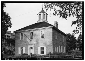
Indiana's first Capitol Building in Corydon was the state's government seat from 1816 to 1825.
|

Many immigrants came to Indiana in the early 1800s. The largest group was Germans. Many people from Ireland and England also settled there. The arrival of steamboats on the Ohio River and the National Road helped more people move to Indiana.
After becoming a state, Indiana worked to grow and develop. In 1836, the state started a plan to build roads, canals, and railroads. This plan was very expensive and caused financial problems for the state. To fix this, a new constitution was adopted in 1851. It stopped the state from going into debt and allowed African Americans to vote.
Civil War and Industry Growth
During the American Civil War, Indiana was very important. It was the first western state to join the Union side. Indiana sent over 200,000 men to fight. More than 35% of them were hurt or died. Only two small battles happened in Indiana during the war.
After the war, Indiana was still mostly a farming state. But the discovery of natural gas in the 1880s changed things. Cheap gas attracted many factories. This created jobs and brought new settlers from other parts of the U.S. and Europe. Cities like South Bend, Indianapolis, and Fort Wayne grew quickly.
The 1900s and Beyond
In the early 1900s, Indiana became a major manufacturing state. Heavy industries grew in the north. In 1906, the United States Steel Corporation built a new city called Gary on Lake Michigan. Indiana was also a leader in making cars. The first successful car company in the U.S., Haynes-Apperson, started in Kokomo in 1896. The Indianapolis Motor Speedway was built in 1909, showing how important cars were to the state.
After World War II, Indiana's economy grew. Factories became the main employers. Cities grew a lot in the 1950s and 1960s. Car, steel, and medicine companies were big businesses. Indiana's population grew to over five million by 1970.
In the 1970s, an oil crisis hurt Indiana's car industry. Many factories closed or downsized, causing job losses. But by the 1980s, the state's economy started to recover and become more diverse.
Indiana's Landscape

Indiana covers about 36,418 square miles. This makes it the 38th largest state. It is about 250 miles long from north to south and 145 miles wide from east to west. The middle of the state is in Marion County.
Indiana is in the Midwestern United States. It is one of eight states in the Great Lakes Region. Michigan is to the north, Ohio to the east, and Illinois to the west. Lake Michigan is to the northwest. The Ohio River forms the southern border with Kentucky.
Land and Hills

Indiana's average height is about 760 feet above sea level. The highest point is Hoosier Hill at 1,257 feet. The lowest point is 320 feet, where the Wabash River meets the Ohio River.
Northern and central Indiana are mostly flat. This area was shaped by glaciers long ago. The soil is good for farming. Northern Indiana also has some hills and many small lakes. In northwest Indiana, there are sand dunes near Indiana Dunes National Park.
Southern Indiana is different. It has valleys and rugged, hilly land. This area has a lot of Indiana limestone, which means there are many caves and quarries.
Rivers and Lakes

Important rivers in Indiana include the Whitewater, White, Blue, Wabash, St. Joseph, and Maumee rivers. Indiana has about 24,000 miles of rivers and streams.
The Wabash River is Indiana's official river. It is 475 miles long and flows through the state from northeast to southwest. It forms part of the border with Illinois before joining the Ohio River. Many songs have been written about the Wabash River.
Indiana has about 900 lakes. Lake Michigan is to the northwest. It is one of the five Great Lakes, the largest group of freshwater lakes in the world. Tippecanoe Lake is the deepest lake in Indiana, almost 120 feet deep. Lake Wawasee is the largest natural lake. Monroe Lake is the largest lake overall.
Weather in Indiana

Indiana has a humid continental climate in the north and a humid subtropical climate in the south. This means cold winters and hot, wet summers. Temperatures are usually colder in the north and warmer in the south.
In winter, average temperatures range from 15°F (−10°C) in the far north to 24°F (−4°C) in the far south. In summer, temperatures range from 64°F (18°C) in the far north to 69°F (21°C) in the far south. The highest temperature ever recorded in Indiana was 116°F (47°C) in 1936. The lowest was −36°F (−38°C) in 1994.
Rainfall is spread out evenly through the year. The state gets about 40 inches of rain annually. Snowfall varies, from 80 inches in the northwest near Lake Michigan to 14 inches in the far south.
Indiana can have tornadoes. In a 2012 report, Indiana was ranked eighth among the top 20 states for tornadoes.
People of Indiana
| Historical population | |||
|---|---|---|---|
| Census | Pop. | %± | |
| 1800 | 2,632 | — | |
| 1810 | 24,520 | 831.6% | |
| 1820 | 147,178 | 500.2% | |
| 1830 | 343,031 | 133.1% | |
| 1840 | 685,866 | 99.9% | |
| 1850 | 988,416 | 44.1% | |
| 1860 | 1,350,428 | 36.6% | |
| 1870 | 1,680,637 | 24.5% | |
| 1880 | 1,978,301 | 17.7% | |
| 1890 | 2,192,404 | 10.8% | |
| 1900 | 2,516,462 | 14.8% | |
| 1910 | 2,700,876 | 7.3% | |
| 1920 | 2,930,390 | 8.5% | |
| 1930 | 3,238,503 | 10.5% | |
| 1940 | 3,427,796 | 5.8% | |
| 1950 | 3,934,224 | 14.8% | |
| 1960 | 4,662,498 | 18.5% | |
| 1970 | 5,193,669 | 11.4% | |
| 1980 | 5,490,224 | 5.7% | |
| 1990 | 5,544,159 | 1.0% | |
| 2000 | 6,080,485 | 9.7% | |
| 2010 | 6,483,802 | 6.6% | |
| 2020 | 6,785,528 | 4.7% | |
| 2024 (est.) | 6,924,275 | 6.8% | |
| Source: 1910–2020 | |||
In 2020, Indiana's population was 6,785,528 people. This was a 4.65% increase since 2010. The state's population density was 181 people per square mile.
In 2018, most immigrants to Indiana came from Mexico, India, China, Myanmar, and the Philippines. Fort Wayne has one of the largest communities of Burmese immigrants in the U.S.
Ancestry and Diversity

The largest ancestry group in Indiana is German. About 18.8% of the population reported German ancestry. Many people also have English (11.1%) and Irish (9.8%) ancestry.
Indiana also has a growing Hispanic population, making up 7.8% of the total. Most of them are of Mexican descent. The majority of the state's African American population lives in the Indianapolis and Gary areas.
Growing Cities

Since 1990, most of Indiana's population growth has been around Indianapolis. Hamilton, Hendricks, Johnson, and Hancock counties have grown the fastest.
Indianapolis is the largest city in Indiana, with 887,642 people in 2020. Other large cities include Fort Wayne (263,886), Evansville (117,298), and South Bend (103,453). Fishers has grown the most among the largest cities since 2000.
Religion in Indiana

Most people in Indiana are Christians. The largest single religious group is Catholic. Many Hoosiers are also members of different Protestant churches. The United Methodist Church is the largest Protestant group.
Indiana is home to the St. Meinrad Archabbey, one of only two Catholic archabbeys in the U.S. The Islamic Society of North America has its main office in Plainfield. Indiana also has the third largest population of Amish people in the United States.
How Indiana is Governed

Indiana has a government with three parts:
- The executive branch is led by the elected governor and lieutenant governor.
- The legislative branch is the Indiana General Assembly, which has two parts: the Senate and the House of Representatives.
- The judicial branch includes the Indiana Supreme Court and other courts.
The Governor of Indiana is the state's chief leader. The governor and lieutenant governor are elected together for four-year terms. The governor can serve two terms in a row. The governor works with the General Assembly and the Supreme Court to run the state.
The Indiana General Assembly makes the state's laws. It has a 50-member Senate and a 100-member House of Representatives. Both parts must agree on a bill before it can become a law.
The Indiana Supreme Court has five judges. The Indiana Court of Appeals has 15 judges. Judges for these courts are chosen by the governor from a list of candidates. After two years, judges must be approved by voters to serve a 10-year term.
Indiana is divided into 92 counties. Each county has its own local government. Most cases start in local courts.
In 2017, U.S. News & World Report ranked Indiana first for best state governments. This was because of its clear budget and stable finances.
Military Bases

Indiana has several military bases. The largest is the Naval Surface Warfare Center Crane Division. It is about 25 miles southwest of Bloomington. It is the third-largest naval base in the world.
Other active bases include Air National Guard units in Fort Wayne and Terre Haute. The Army National Guard operates at Camp Atterbury and the Muscatatuck Urban Training Center.
Indiana Politics

Indiana has a history of its leaders being involved in national politics. Many people from Indiana have been nominated for Vice President. Benjamin Harrison from Indiana was elected President in 1888. He is the only President from Indiana.
Indiana has often been a strong state for the Republican Party. However, there have been times when Democrats won elections, especially during the New Deal era in the 1930s.
In recent presidential elections, Indiana has voted for the Republican candidate. Donald Trump won the state in 2016, 2020, and 2024.
Indiana elects two senators and nine representatives to Congress. Currently, seven representatives are Republicans and two are Democrats. Republicans also hold many seats in the Indiana General Assembly.
Culture and Fun
Arts and Literature
The late 1800s and early 1900s were a "golden age" for Indiana literature. Writers like Edward Eggleston wrote popular books about the state. James Whitcomb Riley, known as the "Hoosier Poet," wrote many poems about Indiana life.
Indiana also developed its own art style. The Hoosier Group of painters used bright colors to show Indiana's landscapes. Famous musicians like Paul Dresser also came from Indiana. His song, "On the Banks of the Wabash, Far Away", is the official state song.
Sports in Indiana
Car Racing
_2017_Indianapolis_500.jpg)
Indiana is famous for auto racing. The Indianapolis 500 race happens every May at the Indianapolis Motor Speedway. It is called "The Greatest Spectacle in Racing" and attracts over 250,000 people. The track also hosts other big races like the Brickyard 400 (NASCAR).
Indiana also hosts the world's largest drag race, the NHRA U.S. Nationals. This event takes place every Labor Day weekend.
Professional Sports Teams

Indiana has produced more National Basketball Association (NBA) players per person than any other state. High school basketball started in Indiana. The NBA's Indiana Pacers play in Indianapolis. They joined the NBA in 1976. The movie Hoosiers is based on a true story about an Indiana high school basketball team. Famous basketball player Larry Bird grew up in Indiana.
Indianapolis is home to the Indianapolis Colts football team. The Colts moved to Indianapolis in 1984. They won Super Bowl XLI in 2007.
Here are some professional sports teams in Indiana:
| Club | Sport | League | Venue (capacity) |
|---|---|---|---|
| Indianapolis Colts | American football | National Football League | Lucas Oil Stadium (62,400) |
| Indiana Pacers | Basketball | National Basketball Association | Gainbridge Fieldhouse (18,165) |
| Evansville Otters | Baseball | Frontier League | Bosse Field (5,181) |
| Evansville Thunderbolts | Ice hockey | SPHL | Ford Center (9,000) |
| Fort Wayne Komets | Ice hockey | ECHL | Allen County War Memorial Coliseum (10,480) |
| Fort Wayne TinCaps | Baseball | High-A Central | Parkview Field (8,100) |
| Gary SouthShore RailCats | Baseball | American Association | U.S. Steel Yard (6,139) |
| Indiana Fever | Basketball | Women's National Basketball Association | Gainbridge Fieldhouse (18,165) |
| Noblesville Boom | Basketball | NBA G League | Gainbridge Fieldhouse (18,165) (Noblesville Event Center (3,400) in 2025–26) |
| Indy Eleven | Soccer | United Soccer League | Michael A. Carroll Stadium (10,524) |
| Indy Fuel | Ice hockey | ECHL | Indiana Farmers Coliseum (6,300) |
| Indianapolis Indians | Baseball | Triple-A East | Victory Field (14,230) |
| Indianapolis Enforcers | Arena football | AAL | Indiana Farmers Coliseum |
| South Bend Cubs | Baseball | High-A Central | Four Winds Field (5,000) |
College Sports
.jpg)


Indiana has many successful college sports teams. In men's basketball, the Indiana Hoosiers have won five national championships. The Purdue Boilermakers have won many Big Ten championships.
In college football, the Notre Dame Fighting Irish have won 11 national championships. The Purdue Boilermakers have also won Big Ten championships and major bowl games.
Many Indiana universities have NCAA Division I athletic programs:
| Program | Division | Conference | City |
|---|---|---|---|
| Ball State Cardinals | Division I FBS | Mid-American Conference | Muncie |
| Butler Bulldogs | Division I FCS | Big East Conference | Indianapolis |
| Evansville Purple Aces | Division I (non-football) | Missouri Valley Conference | Evansville |
| Indiana Hoosiers | Division I FBS | Big Ten Conference | Bloomington |
| Indiana State Sycamores | Division I FCS | Missouri Valley Conference | Terre Haute |
| IU Indy Jaguars | Division I (non-football) | Horizon League | Indianapolis |
| Notre Dame Fighting Irish | Division I FBS | Atlantic Coast Conference | South Bend |
| Purdue Boilermakers | Division I FBS | Big Ten Conference | West Lafayette |
| Purdue Fort Wayne Mastodons | Division I (non-football) | Horizon League | Fort Wayne |
| Southern Indiana Screaming Eagles | Division I (non-football) | Ohio Valley Conference | Evansville |
| Valparaiso Beacons | Division I FCS | Missouri Valley Conference | Valparaiso |
Economy and Travel


In 2017, Indiana had about 3.4 million workers. Its unemployment rate was 3.4%, which is lower than the national average. A large part of Indiana's economy comes from manufacturing. About 17% of the state's workers are in manufacturing, the highest of any U.S. state. Indiana's top exports include vehicles, car parts, and medicines.
Indiana is in the U.S. Corn Belt and Grain Belt. It grows a lot of corn and soybeans. Other crops include melons, tomatoes, and popcorn.
In 2011, CEO magazine ranked Indiana as the best place to do business in the Midwest.
Taxes in Indiana
Indiana has a flat state income tax rate of 3.23%. Many counties also collect income tax. The state sales tax rate is 7%. Food and medicines are usually not taxed. Property taxes are also collected. A "circuit breaker" law limits property taxes for homeowners to 1% of their property's value.
Energy Sources

Indiana mostly uses fossil fuels, especially coal, to make electricity. It has 24 coal power plants. Gibson Generating Station is the country's largest coal power plant.
Indiana has a lot of coal reserves. While the state is working to use more renewable energy like wind and solar, coal is still very common. Wind power has been growing quickly. By 2020, Indiana had 2,968 MW of wind turbines.
Getting Around Indiana
Airports
Indianapolis International Airport serves the Indianapolis area. It was rebuilt in 2008. Other major airports include Evansville Regional Airport, Fort Wayne International Airport, and South Bend International Airport. Many people in Northwest Indiana use Chicago's airports.
Roads and Highways

Indiana has many Interstate highways. These include I-64, I-65, I-69, I-70, I-74, I-80, I-90, and I-94. The many highways that cross in and around Indianapolis are why Indiana's motto is "Crossroads of America."
A large project is extending I-69. The first five parts, connecting Evansville to Martinsville, are now finished. The last part, from Martinsville to Indianapolis, is being built.
Most Indiana counties use a grid system for county roads. This makes it easier to find places.
Trains

Indiana has over 4,255 miles of railroad tracks. Most are used by large freight companies like CSX Transportation and Norfolk Southern Railway. Amtrak also operates passenger trains. The South Shore Line is a commuter train system that runs from Chicago to South Bend.
Ports
_87j082.jpg)
Indiana ships over 70 million tons of cargo by water each year. More than half of Indiana's border is water. This includes access to the Great Lakes/St. Lawrence Seaway and the Ohio River. The Ports of Indiana manages three major ports: Burns Harbor, Jeffersonville, and Mount Vernon.
Learning in Indiana
Public Schools

Indiana's first constitution in 1816 was the first in the U.S. to plan for a state-funded public school system. However, it took time to set up. In the 1840s, Caleb Mills pushed for tax-supported schools. His ideas were included in the new state constitution of 1851.
In 1843, a law said African Americans could not attend public schools. This led to schools like Union Literary Institute being created for them. In 1869, Indiana allowed separate but equal schools for Black students. Later, in 1877, the law changed to allow integrated schools.
Most children in Indiana go to public schools. Some attend private or religious schools. About half of all college students in Indiana go to state-supported four-year universities.
Indiana public schools have new standards adopted in 2014. These standards help make sure students are ready for college or jobs after high school. In 2022, Indiana's high school graduation rate was 86.7%.
Colleges and Universities
Indiana has a large community college system called Ivy Tech Community College of Indiana. It serves almost 200,000 students each year.
The largest university system is Indiana University. Its main campus in Bloomington started in 1820. Indiana State University was founded in Terre Haute in 1865. Purdue University in West Lafayette started in 1869. Other state universities include Vincennes University, Ball State University, and the University of Southern Indiana.
Many private colleges in Indiana are connected to religious groups. These include the University of Notre Dame (Catholic) and Butler University (Protestant).
Several Indiana universities are ranked among the best in the country. The University of Notre Dame is in the top 20. Purdue University is in the top 50, and Indiana University Bloomington is in the top 100. Purdue's engineering programs are ranked fourth in the U.S. Rose-Hulman Institute of Technology has been named the nation's top undergraduate engineering school for 25 years in a row.


Partner Jurisdictions
Indiana has three official partner regions around the world:
 Zhejiang, China (since 1987)
 Tochigi Prefecture, Japan (since 1999)
 Karnataka, India (since 2017)
See also
 In Spanish: Indiana para niños
- Index of Indiana-related articles
- Outline of Indiana
- List of people from Indiana
- USS Indiana, 4 ships
