
Description of the Western Isles of Scotland facts for kids
Description of the Western Isles of Scotland is a very old book that tells us about the Hebrides and the Islands of the Clyde. These are two groups of islands off the west coast of Scotland. The book was written by Donald Monro, who was a church leader known as the "Dean of the Isles." He lived during a time of big changes in the church, called the Scottish Reformation.
Monro finished writing his book in 1549. But it wasn't printed until 1582, and most people couldn't read it until 1774. A more complete version came out much later, in 1961. Monro wrote in Scots, which is an old language, so some parts are hard for us to understand today. Even though some people said Monro included too many old stories and not enough church details, his Description is still a very important historical record. It's one of the most quoted books about the western islands of Scotland.
Monro also wrote a short section about the five main families of Clan Donald that were around in his time. This part was called "The Genealogies Of The Chief Clans Of The Iles." It was added when the Description was first published on its own in 1805. Another old copy of the book, called the Sibbald manuscript, also talks about the "Council of the Isles." This council met on Eilean na Comhairle in Loch Finlaggan on the island of Islay. This is the best record we have of this important court that used to exist under the Lordship of the Isles until it ended in the late 1400s.


Contents
- Who Was Donald Monro?
- Earlier Writings About the Islands
- What People Thought of Monro's Book
- Identifying the Islands
- Family Histories (Genealogies)
- The Council of the Isles
- Images for kids
Who Was Donald Monro?

Donald Monro was born in the early 1500s. He was the oldest of six sons. His father was Alexander Monro of Kiltearn. Donald became a church leader in Snizort and Raasay in 1526. He was likely made Archdeacon of the Isles around 1549.
This was a difficult time in the Highlands and Islands. A man named Domhnall Dubh was trying to bring back the old Lordship of the Isles, but his efforts failed when he died in 1545. Because of this, the church in the Isles was very poor. Even though Monro listed many islands as belonging to his Bishop, it was hard to collect money from them.
In 1549, Monro visited most of the islands on Scotland's west coast. He wrote down what he saw and also included a short family history of different branches of Clan Donald. He called himself "High Dean of the Isles," which was a powerful position. However, the Reformation was changing things, making the political situation even more complex.
In 1560, a new set of beliefs for the church was adopted. Monro became a Protestant and started working as a minister in Kiltearn. He later added other areas to his duties. People say he lived at Castle Craig and traveled across the Cromarty Firth to preach. He was a special Commissioner who helped set up new churches for 12 years. He never married, and there is no stone marking his grave. His book is his lasting memory.
Earlier Writings About the Islands

Very long ago, around AD 83, a traveler named Demetrius of Tarsus told a story about a trip to Scotland's west coast. He said it was a dark journey among empty islands. He visited one island where holy men lived. He didn't mention their names or the island's name.
Later, in his book Natural History, Pliny the Elder wrote that there were 30 "Hebudes" islands. He also mentioned "Dumna," which experts believe was the Outer Hebrides. About 80 years later, Ptolemy, using information from earlier sea trips, also talked about the Ebudes. He said there were only five of them, possibly meaning the Inner Hebrides, and also mentioned Dumna.
The first written records of life in the Hebrides started in the 500s AD. This was when the kingdom of Dál Riata was formed. Most of what we know from that time comes from church sites like Iona and Lismore. But in the areas north of Dál Riata, where the islands were controlled by the Picts, there isn't much historical information.
The names of the islands show a mix of languages. Most are from Norse or Gaelic. But some names might be even older, from before the Celtic people arrived. Donald Monro's book in the 1500s was the first full list of Hebridean island names. For some islands, his book gives us the very first written form of their names.
What People Thought of Monro's Book
A writer named Buchanan praised Monro, calling him "a pious and diligent man." Monro's good reputation lasted until 1824. That's when a geologist named John MacCulloch wrote a long criticism. MacCulloch had visited the islands many times. He complained that Monro didn't give enough details about churches. He even said Monro didn't know much about his own church area. MacCulloch also accused Monro of believing too easily in old folk stories.
In 1840, a reverend named Alexander Nicolson wrote that Monro was too trusting. He pointed to Monro's story about cockles (a type of shellfish) forming on a hilltop in a freshwater spring on Barra. However, 120 years later, R. W. Munro was kinder. He noted that Donald Monro usually made it clear when he was sharing folk tales versus facts. He also said that MacCulloch's claim that "it is scarcely possible to recognise one in ten" of Monro's island names was wrong. In 1893, Hume Brown tried to identify the islands. He found 121 out of the 209 islands on Monro's list. Monro's Description is still one of the most quoted books about the western islands of Scotland.
Identifying the Islands

Donald Monro wrote his book in Scots. This old language makes some of his descriptions hard to understand in modern English. Sometimes, he just lists islands like this:
- Vicreran: Narrest to the iyle of Belnachna layes the small iyle of Vickeran.
- Nagawna: Hard on the iyle Vyckeran layes ther a small iyland, namit in Erische Ellan Nagaruwa.
If the modern name isn't clear from Monro's spelling, it's hard to know which island he meant. Monro wasn't very good at Gaelic. He often wrote island names as they sounded in English, instead of using their proper Gaelic spellings. R. W. Munro, a later researcher, said that out of 251 islands Monro listed, he couldn't identify 27 for sure. Another 23 were uncertain.
R. W. Munro believed that Donald Monro knew the Outer Hebrides and Iona well. But he thought Monro might have written about the islands near the Argyll coast from what he heard from others. This is because those islands were in a different church area, not Monro's own. Other writers have identified more islands since then. However, some quite large islands still don't seem to be on Monro's lists. They might appear under a different name that we haven't connected yet.
The main way islands are numbered comes from R. W. Munro's work, based on the Sibbald manuscript. The names and numbers from the 1774 Auld version are also included. (Monro himself didn't use a numbering system.) The list is organized by geographical areas to make it easier to use.
Islands of the Firth of Clyde, Kintyre, and the Slate Islands
This section lists islands from the southern parts of Scotland's west coast. It includes well-known islands like the Isle of Man, Ailsa Craig, and Arran. Some smaller islands are also mentioned, like Pladda and Holy Isle.
Monro's list also includes islands like Bute, Inchmarnock, Great Cumbrae, and Little Cumbrae. He then moves south to Sanda and Rathlin Island, which is now part of Northern Ireland. Further north, he lists Cara, Gigha, Jura, and Scarba.
The list continues with smaller islands and rocks, some of which are hard to identify today. For example, "Ellan wellich" is thought to be Eilean a Bealach, a small rock. The list then covers the Slate Islands, including Luing, Seil, Shuna, and Easdale. One island, Eilean-a-beithich, no longer exists because it was quarried away for its slate.
Two islands in this section, Vickeran and Nagvisog, are still completely unknown. There are also some difficulties with identifying islands numbered 22–24. If R. W. Munro's identifications are correct, Donald Monro missed the large island of Garbh Eilach, which gives its name to the Garvellachs group. Insh in the Slate Islands is also missing.
Islands Near Craignish, Taynish, Jura, and the Firth of Lorn
R. W. Munro couldn't identify several islands in this group. But another researcher, Youngson (2001), used his local knowledge to suggest some small islands off Jura. In some cases, there are other possible islands nearby.
Monro's descriptions in this section are often just names in English and "Erische" (Gaelic). This makes it hard to be sure which island he meant. Youngson believes that the islands around Jura are listed counter-clockwise, starting from Eilean Mor. This is different from how Islay's islands are listed (clockwise). However, this would mean that several large islands, like Eilean Rìgh and Island Macaskin, are not found anywhere in Monro's list.


This section also includes islands in Loch Linnhe and the Firth of Lorn, such as Eilean nan Caorach, Shuna, and Eilean Musdile. It also lists Bernera, Eilean Ramsay, and Kerrera.
Islay's Islands
Monro wrote, "Her begin to circkell Iyla, sune gaittis aboute with litle iyles." This means he started listing the small islands around Islay in a clockwise direction. Many islands are listed, including some very tiny ones or skerries (small rocky islands). This detailed list for Islay is different from how he missed some larger, inhabited islands in the Outer Hebrides.
There are many similarities between Timothy Pont's map of Islay (published by Johan Blaeu in 1654) and Buchanan's version of Monro's list. It's possible Pont knew about Monro's work and added some islets based on it. However, the connections to modern maps and names are not always clear. Some of the language links between the names are also confusing. For example, "Hessil" might be related to "hazel" trees.
Islands listed here include Texa, Orsay, Nave Island, and many smaller, less identifiable islets around Islay.

Colonsay and Mull Islands
This section covers islands like Oronsay and Colonsay. It then moves to Mull and its surrounding islands. These include Erraid, Iona (a very famous island), and Soa Island.


Further north, the list includes Ulva, Little Colonsay, Gometra, and Staffa. Staffa is a small island famous for its unique rock columns, but it wasn't well-known in Monro's time. The list continues with Cairn na Burgh Mòr and Cairn na Burgh Beag, then Fladda, Treshnish Isles, Lunga, Treshnish Isles, and Bac Mòr. Finally, it lists Tiree, Gunna, and Coll.
The section also mentions Calve Island off Mull, and the Glas Eileanan (Green Islands).
The Small Isles

This group of islands is well-known today. Monro lists them as:
Skye and Nearby Islands
This section starts with Soay and then the large island of Skye itself. Other islands listed include Ornsay, Pabay, and Scalpay.
Monro also mentions the Crowlin Islands, Raasay, and South Rona. He then lists Longa Island, Staffin Island (also called Fladdaidh), and Tulm Island. Further west, he includes Oronsay, Loch Bracadale and Wiay.
Some unnamed islands are mentioned in Loch Bracadale and Loch Dunvegan. The list continues with Isay and the Ascrib Islands.
Barra and the Uists
John Lorne Campbell (1936) believed that Monro had visited Barra but wrote about the smaller islands from what he heard. Islands 156–164 are also known as the Bishop's Isles. Monro didn't treat Benbecula, South Uist, and North Uist as separate islands. He described Uist as one large area with different parts.
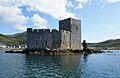
The list includes islands like Lingeigh, Greanamul, Barra Head, Mingulay, Pabbay, Barra, and Flodday near Vatersay. It also lists Muldoanich, Sandray, and Vatersay, before reaching Barra itself.
Other islands mentioned are Orosay, Garbh Lingeigh, Flodday, Sound of Barra, Fuiay, Hellisay, Gighay, Lingay, Fiaraidh, Fuday, and Eriskay.
Monro then lists Uist and the Monach Isles. He also mentions Haskeir and Hirta (part of St Kilda), and Vallay. Many islands are missing from these lists, such as Ronay, Stuley, Baleshare, Kirkibost, and Calvay.
Lewis and Harris and the North West Coast
Lewis and Harris is the largest island in Scotland. It has two main parts, Lewis in the north and Harris in the south, which are often called separate islands even though they are connected. The island doesn't have one common name.
Harris Islands
This section includes islands like Shillay, Stromay, Pabbay, Harris, Berneray, North Uist, Ensay, Outer Hebrides, Killegray, Saghaigh Beag, Saghaigh Mòr, Hermetray, Sgarabhaigh, and Groaigh. Some islands like "Linga" and "Ferelay" are still hard to identify.
The list continues with Gilsay, Tahay (possibly), and then Soay Beag, Soay Mòr, and Ìosaigh. It also includes Taransay, Sleicham (possibly), and Scarp. Finally, it lists the Flannan Isles.
Loch Ròg Islands
This part lists islands within Loch Ròg, such as Seanna Chnoc, Flodaigh, Outer Loch Ròg, Cealasaigh, Little Bernera, and Great Bernera. It also includes Eilean Chearstaidh, Fuaigh Beag, Fuaigh Mòr, Vacsay, Pabaigh Mòr, Siaram Mòr, and Siaram Beag. Some small outer islands like Bearasaigh and Cealasaigh are missing.
Lewis Islands
This section starts with "Pigmeis Ile," which is the "dry island" of Luchraban. There's an old story about tiny people living there. Other islands listed are Eilean Mòr Phabail, Eilean a' Chrotaich (possibly), and Eilean nan Uan.
Monro also mentions Eilean Thuilm (Holm Island) near Stornoway. The list continues with Eilean na Gobhail, Tannaraidh, and Eilean Mòr Lacasaidh. It then lists Eire (possibly), Eilean Chaluim Chille, Eilean Thoraidh, and Eilean Liubhaird.
Finally, it includes Scalpay, Outer Hebrides, Fladda-chuain, Garbh Eilean (part of the Shiant Isles), and Eilean Mhuire. Some islands like Seaforth Island and Boreray are not mentioned.
North Highland Coast Islands
This section lists islands along the northern coast of mainland Scotland. These include the Isle of Ewe, Gruinard, and Priest Island. Some islands like "Ellan af vill" are unidentified. The list also has Tanera Mòr, Tanera Beag, Horse Island, and Isle Martin. Missing from this list are islands like Isle Ristol and Handa.

Lewis and Harris (Final Section)
This last part of the list mentions Lewis and Harris again, followed by North Rona and Sula Sgeir.
Family Histories (Genealogies)
Monro included a short description of the five main branches of Clan Donald that existed in his time. He called this section "Heir Followis The Geneologies Of The Chieff Clans Of The Iles" (Here Follows The Genealogies Of The Chief Clans Of The Isles).

The clans he described were:
- Clan Macdonald of Sleat: Their leader in Monro's day was Donald Gormeson.
- Clan Eanmore of Dunnyveg.
- Clan Ragnald: Led by John Moidartach.
- Clan-Ean of Ardnamorachin.
- The House of Alexander Carrath: Monro said he was "the fairest hared man (as they say) of aney that ever was" (the most fair-haired man, as they say, of any that ever was).
Clan Donald are descendants of a person named Somerled. Monro claimed that in earlier times, this family was known as "Clan Gothofred." He wrote that Somerled's family was called Clan Gothofred, or Clan Gotheray in Gaelic, and they were very important people back then. The name "Gofraid" also appears in many other family histories of Somerled.
The Council of the Isles


Finlaggan was the place where the court of the Buachaille nan Eileanan (the chief of Clan Donald) met. Eilean na Comhairle (which means "council island") was originally a wooden platform built on a lake in the 1st century BC. It was just off the shore from Eilean Mòr (meaning "large island"), which was known as the Island of St Findlugán in the Middle Ages.
The older versions of Monro's book only briefly mention Finlaggan. But the Sibbald manuscript has a much longer and more detailed description. It's the earliest and most detailed account we have. Monro describes the members of the Council, saying it included "14 of the Iles best Barons" (14 of the Isles' best noblemen). He also explains its role as the highest court of justice.
After the Lordship of the Isles was taken away by King James IV in 1493, the buildings at Finlaggan were destroyed. The special stone used for coronations (crowning ceremonies) was also broken. This was done to stop anyone from trying to bring the Lordship back. The Council was briefly restarted in 1545 during a rebellion, just four years before Monro wrote his book.
The noblemen (barons) listed by Monro as members of the Council are:

- Maclean of Duart
- Maclean of Lochbuie
- MacLeod of Harris
- MacLeod of Lewis
- Mackinnon
- McNaie (whose identity is unknown)
- MacNeill of Gigha
- MacNeil of Barra
- MacDonald of Dunnyveg
- MacDonald of Ardnamurchan
- Clanranald
- MacDonald of Lochaber
- Bishop of the Isles
- Abbot of Iona
Images for kids
-
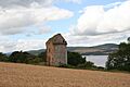
Castle Craig on the Black Isle, with the Cromarty Firth beyond. Donald Monro may have lived here in the 1560s.
-
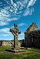
The 8th century Kildalton Cross on Islay, carved when the island was part of Dál Riata.
-

Johan Blaeu's 1654 atlas of "Ila Insula".
-
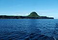
The distinctive outline of Bac Mòr, also known as the "Dutchman's Cap".
-
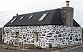
Cottage on Tiree.
-
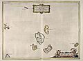
Blaeu's 1654 Atlas of Scotland – The Small Isles.
-
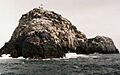
Sula Sgeir from the south west. Donald Monro wrote that the men of Ness sailed there in their small craft to "fetche hame thair boatful of dry wild fowls", a tradition that continues to this day.
-
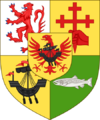
The arms of Macdonald of Macdonald.
-
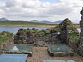
Ruins on Eilean Mòr in Loch Finlaggan, looking toward the Paps of Jura and the hills of Islay.
-
Kisimul Castle, the seat of MacNeil of Barra.
