
Geography of Brazil facts for kids
Quick facts for kids Geography of Brazil |
|
|---|---|
 |
|
| Continent | South America |
| Coordinates | 10°S 55°W / 10°S 55°W |
| Area | Ranked 5th |
| • Total | 8,514,877 km2 (3,287,612 sq mi) |
| • Land | 99.34% |
| • Water | 0.66% |
| Coastline | 7,491 km (4,655 mi) |
| Borders | Argentina 1,263 km (785 mi) Bolivia 3,403 km (2,115 mi) Colombia 1,790 km (1,110 mi) French Guiana 649 km (403 mi) Guyana 1,308 km (813 mi) Paraguay 1,371 km (852 mi) Peru 2,659 km (1,652 mi) Suriname 515 km (320 mi) Uruguay 1,050 km (650 mi) Venezuela 2,137 km (1,328 mi) |
| Highest point | Pico da Neblina 2,995.30 m (9,827 ft) |
| Lowest point | Atlantic Ocean, 0 m (0 ft) |
| Longest river | Amazon River, 6,992 km (4,345 mi) |
| Largest lake | Lagoa dos Patos 9,850 km2 (3,803 sq mi) |
| Climate | North: tropical, South: temperate |
| Terrain | Coastal mountain ranges, vast central plateau (Planalto Central), remainder is primarily sedimentary basins |
| Natural Resources | bauxite, gold, iron ore, manganese, nickel, phosphates, platinum, tin, clay, rare earth elements, uranium, petroleum, hydropower and timber |
| Natural Hazards | recurring droughts in northeast; floods and occasional frost in south |
| Environmental Issues | deforestation in the Amazon basin, illegal wildlife trade, illegal poaching, air and water pollution, land degradation and water pollution caused by mining activities, wetland degradation and severe oil spills |
Brazil is a huge country in South America, taking up about half of the continent. It borders the Atlantic Ocean on its eastern side. Brazil is the 5th largest country in the world, covering a total area of about 8.5 million square kilometers. Most of this is land, with a small part being water.
The highest point in Brazil is Pico da Neblina, which is about 2,994 meters tall. Brazil shares borders with many countries: Argentina, Bolivia, Colombia, Guyana, Paraguay, Peru, Suriname, Uruguay, Venezuela, and French Guiana (which is part of France). The only South American countries it doesn't border are Chile and Ecuador.
Most of Brazil has a tropical climate, meaning it's warm all year. However, the southern part of the country has a more mild, temperate climate. The Amazon River, one of the longest rivers in the world, flows through Brazil.
Contents
Brazil's Size and Location
Brazil is a giant country. Only Russia, Canada, China, and the United States are bigger. It stretches about 4,397 kilometers from north to south and about 4,320 kilometers from east to west. Because it's so wide, Brazil has four different time zones! The capital city, Brasília, is two hours ahead of Eastern Standard Time in the United States.
Brazil also owns several islands in the Atlantic Ocean. The most famous is Fernando de Noronha, located about 350 kilometers northeast of the mainland. Brazil's Atlantic coastline is very long, stretching for about 7,367 kilometers.
Brazil has six main natural areas, called ecosystems:
- The Amazon Basin: A huge tropical rainforest.
- The Pantanal: A tropical wetland near Paraguay and Bolivia.
- The Cerrado: A savanna (grassland with scattered trees) in the center.
- The Caatinga: A dry, thorny scrubland in the Northeast.
- The Atlantic Forest: A forest along the entire coast.
- The Pampas: Fertile plains in the far South.
Mountains, Plateaus, and Rivers
Brazil's land is very old, unlike the younger Andes mountains. A large part of Brazil is made of ancient rock formations. For example, the famous "sugarloaf mountains" in Rio de Janeiro are giant granite domes shaped by millions of years of erosion.
The main mountain ranges in Brazil are not super tall, usually under 2,000 meters. The Serra do Mar range runs along the Atlantic coast. The highest mountains are found near the northern borders with Guyana and Venezuela.
Most of Brazil's center is a large, uneven plateau called the Planalto Central, averaging about 1,000 meters high. The rest of the country is mostly flat areas drained by rivers. About 41% of Brazil is less than 200 meters above sea level. The coast has thousands of kilometers of beautiful tropical beaches, mangroves, and coral reefs.

Brazil has one of the world's largest river systems, with eight major river basins, all flowing into the Atlantic Ocean. The Amazon and Tocantins-Araguaia basins cover more than half of the country!
The Amazon River is the biggest river system in Brazil. It starts in the Andes mountains and gets water from many smaller rivers. The Amazon River carries one-fifth of the world's fresh water! About 3,615 kilometers of the Amazon are in Brazil. Even over this long distance, the river only drops about 100 meters in height.
Some of the Amazon's main rivers are the Madeira, Tapajós, and Xingu on the south side, and the Rio Negro on the north side. These rivers carry huge amounts of water, much more than rivers like the Mississippi.
Another important river is the Rio São Francisco in the Northeast. It flows about 1,609 kilometers. The Paraná system covers a large part of the country too. Its headwaters form the Pantanal, the world's largest continuous wetlands, covering an area as big as 230,000 square kilometers!
Many of Brazil's rivers are used for transportation, especially the Amazon, which large ships can travel far upstream. Brazil also uses its rivers to create electricity with huge hydroelectric dams like Itaipu.
Brazil's Natural Resources
Brazil is rich in natural resources! These include:
- Bauxite (used for aluminum)
- Gold
- Iron ore
- Manganese
- Nickel
- Phosphates
- Platinum
- Tin
- Clay
- Rare earth elements
- Uranium
- Petroleum (oil)
- Hydropower (electricity from water)
- Timber (wood)
Rivers and Lakes

Brazil has 12 major river regions. Seven of these are named after their main rivers, and the other five are groups of smaller rivers along the coast.
- Major River Basins:
* Amazonas * Paraguai * Paraná * Parnaíba * São Francisco * Tocantins * Uruguay
- Coastal River Groupings (from north to south):
* Western North-east Atlantic * Eastern North-east Atlantic * Eastern Atlantic * South-east Atlantic * South Atlantic
The Amazon River is the widest and second longest river in the world. It drains most of the world's rainforests. The Paraná River also starts in Brazil and flows south, forming borders with Paraguay and Argentina before reaching the Atlantic Ocean.
Soil and Vegetation

Brazil's tropical soils are very productive, growing huge amounts of grain crops each year. The country has the 5th largest area of farmable land in the world. In the past, farmers would burn dry grass to clear land, but now modern methods are used.
The most fertile soils, called terra roxa (red earth), are found in the states of Paraná and São Paulo. The soils in the Amazon are generally not very fertile, even though it has a dense rainforest. Soils in the Northeast can be fertile but often lack water, needing irrigation.
Modern farming has made it possible to grow crops in areas that were once difficult, like the savanna soils. Farmers now use special fertilizers and plant types to make these lands productive for crops like soybeans.
Brazil's many climates and soil types mean it has a huge variety of plants.
- The Amazon Basin and rainy coastal areas have tropical rainforests with many different kinds of trees. These forests are incredibly diverse, with thousands of plant and animal species in a small area. The Atlantic Forest is thought to have even more types of living things than the Amazon!
- In the dry Northeast, you'll find caatinga, which is a tough, thorny type of vegetation.
- Central Brazil has cerrado, a woodland savanna with scattered trees and grasses that can handle dry weather.
- In the South, there are pine forests in the highlands and grasslands similar to the Argentine pampa on the plains.
- The Pantanal wetlands are covered with tall grasses, bushes, and trees, and they get partly flooded during the rainy season.

Brazil is famous for its rich tropical forests. However, much of the original Atlantic Forest has been cut down for farming. In the Amazon, about 15% of the forest has been cleared. When valuable trees like mahogany are cut down, it can damage many other trees around them.
In recent years, there has been a lot of concern about deforestation and fires in the Amazon. Satellites help track these changes. People are working to find ways to use the forest's resources, like wood and other products (such as rubber, Brazil nuts, and fruits), without harming the environment forever.
Brazil's Climate Zones

Even though 90% of Brazil is in the tropical zone, its climate changes a lot. The North, near the equator, is mostly tropical. The South, below the Tropic of Capricorn, has a more temperate climate.
Brazil has five main climate types:
- Equatorial: Hot all year, found near the equator.
- Tropical: Warm with wet and dry seasons.
- Semiarid: Very dry, especially in the Northeast.
- Highland Tropical: Cooler temperatures due to high elevation.
- Subtropical: Mild winters and warm summers, found in the South.
Temperatures near the equator are usually above 25°C (77°F). In the South, it can get cold enough for frost in winter (June-August), and even snow in mountainous areas like Paraná. Cities like São Paulo and Brasília have moderate temperatures because they are high up, around 1,000 meters. Coastal cities like Rio de Janeiro are warm but get cool breezes.
Rainfall also varies. Most of Brazil gets a moderate amount of rain, usually between 1,000 and 1,500 mm per year. The Amazon region is very humid, with over 2,000 mm of rain annually. However, even the Amazon rainforest has a dry season for a few months.
The Northeast is the driest part of Brazil, with little rain and severe droughts. It's also the hottest part of the country, with temperatures sometimes over 38°C (100°F). The central part of Brazil gets a good amount of rain but has a clear dry season in the middle of the year.


.jpg)
Brazil's Geographic Regions
Brazil is divided into 26 states and one Federal District (where Brasília is). These are grouped into five main regions:
- North (Norte)
- Northeast (Nordeste)
- Southeast (Sudeste)
- South (Sul)
- Center-West (Centro-Oeste)
Each region has its own unique ecosystems, economy, and population patterns.

Center-West Region

The Center-West region includes the states of Goiás, Mato Grosso, Mato Grosso do Sul, and the Federal District (where Brasília is). It covers about 18.9% of Brazil's land.
The main natural area here is the cerrado, a tropical savanna with grasslands and small trees. This area used to be for cattle ranching but is now also used for growing soybeans. The western part of the region includes the Pantanal wetlands, famous for their amazing wildlife like birds and caimans.
In 1996, about 10.2 million people lived in the Center-West, which is about 6% of Brazil's total population. The population is spread out, with more people living in cities like Brasília and Goiânia.
Northeast Region

The Northeast region has nine states: Alagoas, Bahia, Ceará, Maranhão, Paraíba, Pernambuco, Piauí, Rio Grande do Norte, and Sergipe. It also includes the Fernando de Noronha islands. This region covers about 18.3% of Brazil's land.
The Northeast has a large rural population, and its living standards are generally lower than in other parts of Brazil. The region is known for its dry caatinga vegetation, but it also has beautiful coastal areas.
North Region (Amazon)

The North region is also called the Amazon or Amazônia. It includes the states of Rondônia, Acre, Amazonas, Roraima, Pará, Amapá, and Tocantins. This is Brazil's largest region, covering 45.3% of the country!
The main natural area here is the humid tropical forest, or rainforest, which has some of the richest biological diversity on Earth. For a long time, this region provided forest products like rubber. More recently, mining, farming, and the lumber industry have become important.
In 1996, about 11.1 million people lived in the North, which was only 7% of Brazil's population. However, the population grew quickly in the 1970s and 1980s as people moved there. Major cities include Belém and Manaus.
Southeast Region

The Southeast region has four states: Espírito Santo, Minas Gerais, Rio de Janeiro, and São Paulo. It's smaller in area, covering about 10.9% of Brazil. But it has the largest share of the country's population, with 63 million people in 1991, or 39% of the total!
This region has huge cities like São Paulo and Rio de Janeiro. It has the highest living standards in Brazil, but also some areas with poverty.
Originally, the Southeast was covered by the Atlantic Forest, but most of it has been cleared for farming and industry. This region is where most of Brazil's factories are located. Farming is also very strong and uses modern technology.
South Region

The South region has three states: Paraná, Rio Grande do Sul, and Santa Catarina. It covers about 6.8% of Brazil's land. In 1991, about 23.1 million people lived here, which was 14% of the country's total. The population is quite dense, especially along the coast. Major cities include Curitiba and Porto Alegre.
People in the South generally have high living standards. The region has important industries and productive agriculture. Besides the Atlantic Forest, the southernmost part of Brazil has grasslands similar to the Uruguayan savanna. Farming here is very productive, and there are also important industries.
Images for kids
-
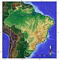
Topographic map of Brazil
See also
 In Spanish: Geografía de Brasil para niños
