Appalachian Ohio facts for kids
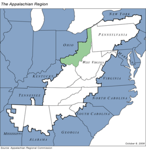
Appalachian Ohio is a unique area in the southeastern part of Ohio. It's known for its rolling hills, which are the western foothills of the famous Appalachian Mountains. This region is also part of the Appalachian Plateau.
The Appalachian Regional Commission says this area includes 32 counties. This part of Ohio is home to a special kind of forest called the Appalachian mixed-mesophytic forest. These forests are found only in central and southern Appalachia and parts of China. They are some of the most diverse temperate forests in the world, meaning they have many different kinds of plants and animals.
Long ago, a giant glacier helped shape the land here. Areas south and east of where the glacier stopped have rough, uneven hills and valleys. This is different from the eastern Appalachian Mountains, which have long, fin-like ridges. Instead, Appalachian Ohio has many rocky valleys and hills going in all directions.
This region is considered part of "central Appalachia." This larger area includes southeastern Ohio, Eastern Kentucky, most of West Virginia, and Southwestern Virginia. About 1.98 million people live in Appalachian Ohio.
Contents
Counties and Their Main Towns
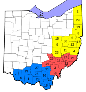
The Governor's Office of Appalachia divides the 32 counties of Appalachian Ohio into three smaller areas. These are East Central Ohio, South East Ohio, and Southern Ohio. Below are the counties in each region and their main towns, called county seats.
| East Central Ohio | South East Ohio | Southern Ohio |
|---|---|---|
|
|
Cities in Appalachian Ohio
Appalachian Ohio has many cities. Here are some of the cities and their populations, based on the 2010 census:
- Youngstown (Population: 66,982) in Mahoning County and Trumbull County
- Warren (Population: 41,557) in Trumbull County
- Zanesville (Population: 25,487) in Muskingum County
- Athens (Population: 23,832) in Athens County
- Chillicothe (Population: 21,901) in Ross County
- Ashtabula (Population: 19,124) in Ashtabula County
- Niles (Population: 19,266) in Trumbull County
- Portsmouth (Population: 20,226) in Scioto County
- Steubenville (Population: 18,659) in Jefferson County
- New Philadelphia (Population: 17,288) in Tuscarawas County
- Marietta (Population: 14,085) in Washington County
- East Liverpool (Population: 11,195) in Columbiana County
- Conneaut (Population: 12,841) in Ashtabula County
- Salem (Population: 12,303) in Mahoning County and Columbiana County
- Dover (Population: 12,826) in Tuscarawas County
- Struthers (Population: 10,713) in Mahoning County
- Coshocton (Population: 11,216) in Coshocton County
- Cambridge (Population: 10,635) in Guernsey County
- Ironton (Population: 11,129) in Lawrence County
- Girard (Population: 9,958) in Trumbull County
- Hubbard (Population: 7,874) in Trumbull County
- Campbell (Population: 8,235) in Mahoning County
- Canfield (Population: 7,515) in Mahoning County
- Martins Ferry (Population: 6,915) in Belmont County
- Cortland (Population: 7,104) in Trumbull County
- Logan (Population: 7,152) in Hocking County
- Belpre (Population: 6,441) in Washington County
- Geneva (Population: 6,215) in Ashtabula County
- Columbiana (Population: 6,384) in Mahoning County and Columbiana County
- Hillsboro (Population: 6,605) in Highland County
- Jackson (Population: 6,397) in Jackson County
- Wellston (Population: 5,663) in Jackson County
- Nelsonville (Population: 5,392) in Athens County
- St. Clairsville (Population: 5,184) in Belmont County
Getting Around: Transportation
For people living in Appalachian Ohio, there are a few main airports. John Glenn Columbus International Airport in Columbus is the largest. It mostly has flights within the country. The Cincinnati/Northern Kentucky International Airport is to the southwest. It serves people in the Cincinnati area. To the north, Cleveland Hopkins International Airport is another big airport.
The Appalachian Regional Commission
The Appalachian Regional Commission (ARC) was created in 1965. Its main goal is to help the Appalachian region grow and improve its economy. At that time, this region was not doing as well as other parts of the country.
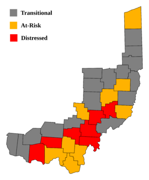
Today, the ARC works with 420 counties across 13 states, including the 32 counties in Ohio. The commission gives each county one of five economic labels. These labels show how well the county is doing financially.
- Distressed counties are the most in need of help.
- At-risk counties are also facing challenges.
- Transitional counties are improving but still have some catching up to do.
- Competitive and Attainment counties are doing well economically.
These labels are based on things like how many people are unemployed, how much money people earn, and how many people live in poverty.
In 2009, Appalachian Ohio had a higher unemployment rate (8.4%) than the rest of Ohio (7.5%) and the country (6.6%). Also, in 2008, the average income per person in Appalachian Ohio was lower ($22,294) than in Ohio ($29,344) and the U.S. ($34,004). In 2009, more people lived in poverty in Appalachian Ohio (16%) compared to Ohio (13.6%) and the U.S. (13.5%).
Seven counties in Ohio were called "distressed" by the ARC. These were Adams, Athens, Meigs, Morgan, Noble, Pike, and Vinton. Nine other counties were "at-risk." These included Ashtabula, Gallia, Guernsey, Harrison, Jackson, Lawrence, Monroe, Perry, and Scioto. The rest of the counties in Appalachian Ohio were "transitional." This means they were behind the national average in at least one important area. No counties in Ohio were labeled "attainment" or "competitive."
Athens County had the highest poverty rate in Appalachian Ohio, with about 32.8% of its people living below the poverty line. Clermont County had the highest income per person ($30,515). Holmes County had the lowest unemployment rate (5.5%).
When it comes to high school graduation, Washington County had the highest rate (84.5%). Adams County had the lowest (68.6%). It's interesting to note that Holmes County has a lower graduation rate (51.5%). This is because many Amish people live there, and their children usually do not go to school past the eighth grade.
Famous People from Appalachian Ohio
Many well-known Americans come from Appalachian Ohio, including:
- John Glenn: A former United States Marine Corps pilot, astronaut, and U.S. senator. He was the first American to orbit the Earth.
- Sarah Jessica Parker: A famous actress and producer.
- Nancy Zimpher: A leader in education, who was chancellor of the State University of New York system.
- Dean Martin: A popular actor and singer.
- Lou Groza: A football player for the Cleveland Browns and a member of the Pro Football Hall of Fame.
- Jimmy the Greek: A sports expert.
- Clark Gable: A legendary actor.
- George Custer: A military leader who served in the American Civil War.
- Ulysses S. Grant: The 18th President of the United States (1869–1877).
- William McKinley: The 25th President of the United States (1897–1901).
- Cy Young: A famous Major League Baseball pitcher. The Cy Young Award is named after him and is given to the best pitcher each year.
- Cody Garbrandt: A professional UFC fighter.
- Stephen Kappes: A high-ranking official who was Deputy Director of the CIA.
- Maya Lin: An architect and artist, known for designing the Vietnam War Memorial in Washington, D.C..
- Katie Smith: A three-time Olympic gold medalist in basketball and a two-time WNBA champion.
- Joe Burrow: A quarterback for the Cincinnati Bengals, the number one pick in the 2020 NFL Draft, and winner of the 2019 Heisman Trophy.
- Jack Roush: The founder and co-owner of the NASCAR team Roush-Fenway Racing.
- Ambrose Bierce: A well-known author.
- Mike Palagyi: A Major League Baseball pitcher.
- J. T. Miller: A professional ice hockey player for the Vancouver Canucks.
See Also


