
List of municipalities in Arizona facts for kids

Arizona is a cool state located in the western part of the U.S.. It's known for its deserts and amazing landscapes! In 2020, about 7.15 million people lived here, making it the 14th most populated state. It's also really big, the 6th largest by land area, covering about 113,623 square miles (294,289 square kilometers).
Arizona is split into 15 counties. Inside these counties, there are 91 official cities and towns. When a place is "incorporated," it means it has its own local government, like a city or town council, to make decisions for its residents. Most people in Arizona live in the Phoenix metropolitan area, which has about 4.8 million residents.
Phoenix is the capital and the biggest city in Arizona. It has over 1.6 million people and is the fifth largest city in the whole United States! It covers a huge area of about 517.5 square miles (1,340 square kilometers). On the other hand, Winkelman is the smallest town, with only 296 people living in about 0.75 square miles (1.9 square kilometers). The oldest city in Arizona is Tucson, which became official in 1877. The newest is Tusayan, which became a town in March 2010.
Contents
Becoming an Official City or Town
Have you ever wondered how a community becomes an official city or town? In Arizona, it's a special process! Since 1912, the state's rules have allowed communities with at least 3,500 people to form their own local governments. This means they can make their own rules, instead of the state making all the decisions for them.
The state has made it a bit easier over time. Now, most places only need 1,500 people to become a town. If a community is super close to a national park or national monument (within 10 miles), it only needs 500 people! However, new towns can't pop up right next to existing big cities. There's a special "buffer zone" around bigger cities to prevent this.
Cities vs. Towns
In Arizona, cities and towns work pretty similarly. The main difference is that to become a city, a place needs at least 3,000 people. Cities also have a few extra powers, especially when it comes to managing things like utilities (water, electricity) and building rules within their borders.
Towns can become cities once they reach 3,000 people. But some really big communities choose to stay as towns! For example, Gilbert has over 267,000 residents, which is more than many cities, but it's still officially a town.
Before Arizona became a state in 1912, some cities and towns became official in different ways. Phoenix, for instance, was made a city way back in 1881 by the Arizona Territorial Legislature, which was the government before Arizona was a state.
Arizona's Biggest Cities and Towns
Here are some of the largest cities and towns in Arizona, based on their population:
- Largest cities and towns in Arizona by population
-
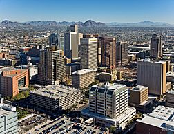
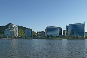
Phoenix, Arizona's state capital and most populous municipality
-
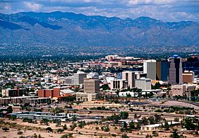
Tucson, Arizona's second largest city by population
-
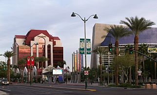
Mesa, a suburb of Phoenix and Arizona's third largest city by population
-
Chandler, a suburb of Phoenix and Arizona's fourth largest city by population
-
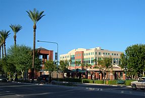
Gilbert, a suburb of Phoenix and Arizona's largest town and fifth largest municipality by population
-
Glendale, a suburb of Phoenix and Arizona's sixth largest city by population
-
Scottsdale, a suburb of Phoenix and Arizona's seventh largest city by population
-
Peoria, a suburb of Phoenix and Arizona's eighth largest city by population
-
Tempe, a suburb of Phoenix and Arizona's ninth largest city by population
-
Surprise, a suburb of Phoenix and Arizona's tenth largest city by population


County seat State capital and county seat
| Name | Type | County | Population (2020) |
Population (2010) |
Change | Land area (2020) | Population density (2020) | Incorporation year | |
|---|---|---|---|---|---|---|---|---|---|
| sq mi | km2 | ||||||||
| Apache Junction | City | Pinal, Maricopa | 38,499 | 35,840 | +7.4% | 35.07 | 90.8 | 1,097.8/sq mi (423.9/km2) | 1978 |
| Avondale | City | Maricopa | 89,334 | 76,238 | +17.2% | 47.28 | 122.5 | 1,889.5/sq mi (729.5/km2) | 1946 |
| Benson | City | Cochise | 5,355 | 5,105 | +4.9% | 41.64 | 107.8 | 128.6/sq mi (49.7/km2) | 1924 |
| Bisbee | City | Cochise | 4,923 | 5,575 | −11.7% | 5.18 | 13.4 | 950.4/sq mi (367.0/km2) | 1902 |
| Buckeye | City | Maricopa | 91,502 | 50,876 | +79.9% | 392.98 | 1,017.8 | 232.8/sq mi (89.9/km2) | 1929 |
| Bullhead City | City | Mohave | 41,348 | 39,540 | +4.6% | 59.37 | 153.8 | 696.4/sq mi (268.9/km2) | 1984 |
| Camp Verde | Town | Yavapai | 12,147 | 10,873 | +11.7% | 42.35 | 109.7 | 286.8/sq mi (110.7/km2) | 1986 |
| Carefree | Town | Maricopa | 3,690 | 3,363 | +9.7% | 8.81 | 22.8 | 418.8/sq mi (161.7/km2) | 1984 |
| Casa Grande | City | Pinal | 53,658 | 48,571 | +10.5% | 110.87 | 287.2 | 484.0/sq mi (186.9/km2) | 1915 |
| Cave Creek | Town | Maricopa | 4,892 | 5,015 | −2.5% | 37.71 | 97.7 | 129.7/sq mi (50.1/km2) | 1986 |
| Chandler | City | Maricopa | 275,987 | 236,123 | +16.9% | 65.30 | 169.1 | 4,226.4/sq mi (1,631.8/km2) | 1920 |
| Chino Valley | Town | Yavapai | 13,020 | 10,817 | +20.4% | 62.42 | 161.7 | 208.6/sq mi (80.5/km2) | 1970 |
| Clarkdale | Town | Yavapai | 4,424 | 4,097 | +8.0% | 10.18 | 26.4 | 434.6/sq mi (167.8/km2) | 1957 |
| Clifton |
Town | Greenlee | 3,933 | 3,311 | +18.8% | 14.62 | 37.9 | 269.0/sq mi (103.9/km2) | 1909 |
| Colorado City | Town | Mohave | 2,478 | 4,821 | −48.6% | 9.20 | 23.8 | 269.3/sq mi (104.0/km2) | 1985 |
| Coolidge | City | Pinal | 13,218 | 11,825 | +11.8% | 76.27 | 197.5 | 173.3/sq mi (66.9/km2) | 1945 |
| Cottonwood | City | Yavapai | 12,029 | 11,265 | +6.8% | 16.60 | 43.0 | 724.6/sq mi (279.8/km2) | 1960 |
| Dewey-Humboldt | Town | Yavapai | 4,326 | 3,894 | +11.1% | 18.79 | 48.7 | 230.2/sq mi (88.9/km2) | 2004 |
| Douglas | City | Cochise | 16,534 | 17,378 | −4.9% | 9.98 | 25.8 | 1,656.7/sq mi (639.7/km2) | 1905 |
| Duncan | Town | Greenlee | 694 | 696 | −0.3% | 2.15 | 5.6 | 322.8/sq mi (124.6/km2) | 1938 |
| Eagar | Town | Apache | 4,395 | 4,885 | −10.0% | 11.58 | 30.0 | 379.5/sq mi (146.5/km2) | 1948 |
| El Mirage | City | Maricopa | 35,805 | 31,797 | +12.6% | 9.90 | 25.6 | 3,616.7/sq mi (1,396.4/km2) | 1951 |
| Eloy | City | Pinal | 15,635 | 16,631 | −6.0% | 113.57 | 294.1 | 137.7/sq mi (53.2/km2) | 1949 |
| Flagstaff |
City | Coconino | 76,831 | 65,870 | +16.6% | 66.03 | 171.0 | 1,163.6/sq mi (449.3/km2) | 1894 |
| Florence |
Town | Pinal | 26,785 | 25,536 | +4.9% | 62.62 | 162.2 | 427.7/sq mi (165.1/km2) | 1908 |
| Fountain Hills | Town | Maricopa | 23,820 | 22,489 | +5.9% | 20.28 | 52.5 | 1,174.6/sq mi (453.5/km2) | 1989 |
| Fredonia | Town | Coconino | 1,323 | 1,314 | +0.7% | 8.88 | 23.0 | 149.0/sq mi (57.5/km2) | 1956 |
| Gila Bend | Town | Maricopa | 1,892 | 1,922 | −1.6% | 64.37 | 166.7 | 29.4/sq mi (11.4/km2) | 1962 |
| Gilbert | Town | Maricopa | 267,918 | 208,453 | +28.5% | 68.57 | 177.6 | 3,907.2/sq mi (1,508.6/km2) | 1920 |
| Glendale | City | Maricopa | 248,325 | 226,721 | +9.5% | 61.60 | 159.5 | 4,031.3/sq mi (1,556.5/km2) | 1910 |
| Globe |
City | Gila | 7,249 | 7,532 | −3.8% | 18.26 | 47.3 | 397.0/sq mi (153.3/km2) | 1907 |
| Goodyear | City | Maricopa | 95,294 | 65,275 | +46.0% | 191.30 | 495.5 | 498.1/sq mi (192.3/km2) | 1946 |
| Guadalupe | Town | Maricopa | 5,322 | 5,523 | −3.6% | 0.80 | 2.1 | 6,652.5/sq mi (2,568.5/km2) | 1975 |
| Hayden | Town | Gila, Pinal | 512 | 662 | −22.7% | 1.27 | 3.3 | 403.1/sq mi (155.6/km2) | 1956 |
| Holbrook |
City | Navajo | 4,858 | 5,053 | −3.9% | 17.34 | 44.9 | 280.2/sq mi (108.2/km2) | 1917 |
| Huachuca City | Town | Cochise | 1,626 | 1,853 | −12.3% | 2.83 | 7.3 | 574.6/sq mi (221.9/km2) | 1958 |
| Jerome | Town | Yavapai | 464 | 444 | +4.5% | 0.79 | 2.0 | 587.3/sq mi (226.8/km2) | 1889 |
| Kearny | Town | Pinal | 1,741 | 1,950 | −10.7% | 2.70 | 7.0 | 644.8/sq mi (249.0/km2) | 1959 |
| Kingman |
City | Mohave | 32,689 | 28,068 | +16.5% | 37.55 | 97.3 | 870.5/sq mi (336.1/km2) | 1952 |
| Lake Havasu City | City | Mohave | 57,144 | 52,527 | +8.8% | 46.34 | 120.0 | 1,233.1/sq mi (476.1/km2) | 1978 |
| Litchfield Park | City | Maricopa | 6,847 | 5,476 | +25.0% | 3.28 | 8.5 | 2,087.5/sq mi (806.0/km2) | 1987 |
| Mammoth | Town | Pinal | 1,076 | 1,426 | −24.5% | 26.32 | 68.2 | 40.9/sq mi (15.8/km2) | 1958 |
| Marana | Town | Pima, Pinal | 51,908 | 34,961 | +48.5% | 121.10 | 313.6 | 428.6/sq mi (165.5/km2) | 1977 |
| Maricopa | City | Pinal | 58,125 | 43,482 | +33.7% | 42.46 | 110.0 | 1,368.9/sq mi (528.5/km2) | 2003 |
| Mesa | City | Maricopa | 504,258 | 439,041 | +14.9% | 138.70 | 359.2 | 3,635.6/sq mi (1,403.7/km2) | 1883 |
| Miami | Town | Gila | 1,541 | 1,837 | −16.1% | 0.89 | 2.3 | 1,731.5/sq mi (668.5/km2) | 1918 |
| Nogales |
City | Santa Cruz | 19,770 | 20,837 | −5.1% | 20.82 | 53.9 | 949.6/sq mi (366.6/km2) | 1893 |
| Oro Valley | Town | Pima | 47,070 | 41,011 | +14.8% | 34.87 | 90.3 | 1,349.9/sq mi (521.2/km2) | 1974 |
| Page | City | Coconino | 7,440 | 7,247 | +2.7% | 38.18 | 98.9 | 194.9/sq mi (75.3/km2) | 1975 |
| Paradise Valley | Town | Maricopa | 12,658 | 12,820 | −1.3% | 15.38 | 39.8 | 823.0/sq mi (317.8/km2) | 1961 |
| Parker |
Town | La Paz | 3,417 | 3,083 | +10.8% | 21.98 | 56.9 | 155.5/sq mi (60.0/km2) | 1948 |
| Patagonia | Town | Santa Cruz | 804 | 913 | −11.9% | 1.29 | 3.3 | 623.3/sq mi (240.7/km2) | 1948 |
| Payson | Town | Gila | 16,351 | 15,301 | +6.9% | 19.35 | 50.1 | 845.0/sq mi (326.3/km2) | 1973 |
| Peoria | City | Maricopa, Yavapai | 190,985 | 154,065 | +24.0% | 176.08 | 456.0 | 1,084.6/sq mi (418.8/km2) | 1954 |
| Phoenix |
City | Maricopa | 1,608,139 | 1,445,632 | +11.2% | 518.00 | 1,341.6 | 3,104.5/sq mi (1,198.7/km2) | 1881 |
| Pima | Town | Graham | 2,847 | 2,387 | +19.3% | 7.30 | 18.9 | 390.0/sq mi (150.6/km2) | 1916 |
| Pinetop-Lakeside | Town | Navajo | 4,030 | 4,282 | −5.9% | 11.15 | 28.9 | 361.4/sq mi (139.5/km2) | 1984 |
| Prescott |
City | Yavapai | 45,827 | 39,843 | +15.0% | 44.97 | 116.5 | 1,019.1/sq mi (393.5/km2) | 1883 |
| Prescott Valley | Town | Yavapai | 46,785 | 38,822 | +20.5% | 40.47 | 104.8 | 1,156.0/sq mi (446.3/km2) | 1978 |
| Quartzsite | Town | La Paz | 2,413 | 3,677 | −34.4% | 36.30 | 94.0 | 66.5/sq mi (25.7/km2) | 1989 |
| Queen Creek | Town | Maricopa, Pinal | 59,519 | 26,361 | +125.8% | 40.32 | 104.4 | 1,476.2/sq mi (570.0/km2) | 1989 |
| Safford |
City | Graham | 10,129 | 9,566 | +5.9% | 9.27 | 24.0 | 1,092.7/sq mi (421.9/km2) | 1901 |
| Sahuarita | Town | Pima | 34,134 | 25,259 | +35.1% | 31.69 | 82.1 | 1,077.1/sq mi (415.9/km2) | 1994 |
| San Luis | City | Yuma | 35,257 | 25,505 | +38.2% | 34.03 | 88.1 | 1,036.1/sq mi (400.0/km2) | 1979 |
| Scottsdale | City | Maricopa | 241,361 | 217,385 | +11.0% | 184.00 | 476.6 | 1,311.7/sq mi (506.5/km2) | 1951 |
| Sedona | City | Yavapai, Coconino | 9,684 | 10,031 | −3.5% | 18.26 | 47.3 | 530.3/sq mi (204.7/km2) | 1988 |
| Show Low | City | Navajo | 11,732 | 10,660 | +10.1% | 65.50 | 169.6 | 179.1/sq mi (69.2/km2) | 1953 |
| Sierra Vista | City | Cochise | 45,308 | 43,888 | +3.2% | 152.25 | 394.3 | 297.6/sq mi (114.9/km2) | 1956 |
| Snowflake | Town | Navajo | 6,104 | 5,590 | +9.2% | 33.74 | 87.4 | 180.9/sq mi (69.8/km2) | 1948 |
| Somerton | City | Yuma | 14,197 | 14,287 | −0.6% | 7.27 | 18.8 | 1,952.8/sq mi (754.0/km2) | 1918 |
| South Tucson | City | Pima | 4,613 | 5,652 | −18.4% | 1.03 | 2.7 | 4,478.6/sq mi (1,729.2/km2) | 1940 |
| Springerville | Town | Apache | 1,717 | 1,961 | −12.4% | 11.50 | 29.8 | 149.3/sq mi (57.6/km2) | 1948 |
| St. Johns |
City | Apache | 3,417 | 3,480 | −1.8% | 25.91 | 67.1 | 131.9/sq mi (50.9/km2) | 1946 |
| Star Valley | Town | Gila | 2,484 | 1,970 | +26.1% | 36.14 | 93.6 | 68.7/sq mi (26.5/km2) | 2005 |
| Superior | Town | Pinal | 2,407 | 2,837 | −15.2% | 1.96 | 5.1 | 1,228.1/sq mi (474.2/km2) | 1976 |
| Surprise | City | Maricopa | 143,148 | 117,517 | +21.8% | 110.30 | 285.7 | 1,297.8/sq mi (501.1/km2) | 1960 |
| Taylor | Town | Navajo | 3,995 | 4,112 | −2.8% | 32.66 | 84.6 | 122.3/sq mi (47.2/km2) | 1966 |
| Tempe | City | Maricopa | 180,587 | 161,719 | +11.7% | 39.94 | 103.4 | 4,521.5/sq mi (1,745.8/km2) | 1894 |
| Thatcher | Town | Graham | 5,231 | 4,865 | +7.5% | 6.60 | 17.1 | 792.6/sq mi (306.0/km2) | 1899 |
| Tolleson | City | Maricopa | 7,216 | 6,545 | +10.3% | 5.73 | 14.8 | 1,259.3/sq mi (486.2/km2) | 1929 |
| Tombstone | City | Cochise | 1,308 | 1,380 | −5.2% | 9.25 | 24.0 | 141.4/sq mi (54.6/km2) | 1881 |
| Tucson |
City | Pima | 542,629 | 520,116 | +4.3% | 240.99 | 624.2 | 2,251.7/sq mi (869.4/km2) | 1877 |
| Tusayan | Town | Coconino | 603 | 558 | +8.1% | 16.83 | 43.6 | 35.8/sq mi (13.8/km2) | 2010 |
| Wellton | Town | Yuma | 2,375 | 2,882 | −17.6% | 28.88 | 74.8 | 82.2/sq mi (31.7/km2) | 1970 |
| Wickenburg | Town | Maricopa, Yavapai | 7,474 | 6,363 | +17.5% | 25.86 | 67.0 | 289.0/sq mi (111.6/km2) | 1909 |
| Willcox | City | Cochise | 3,213 | 3,757 | −14.5% | 6.15 | 15.9 | 522.4/sq mi (201.7/km2) | 1915 |
| Williams | City | Coconino | 3,202 | 3,023 | +5.9% | 43.83 | 113.5 | 73.1/sq mi (28.2/km2) | 1901 |
| Winkelman | Town | Gila, Pinal | 296 | 353 | −16.1% | 0.77 | 2.0 | 384.4/sq mi (148.4/km2) | 1949 |
| Winslow | City | Navajo | 9,005 | 9,655 | −6.7% | 12.99 | 33.6 | 693.2/sq mi (267.6/km2) | 1900 |
| Youngtown | Town | Maricopa | 7,056 | 6,156 | +14.6% | 1.49 | 3.9 | 4,735.6/sq mi (1,828.4/km2) | 1960 |
| Yuma |
City | Yuma | 95,548 | 93,064 | +2.7% | 120.67 | 312.5 | 791.8/sq mi (305.7/km2) | 1914 |
| Total municipalities | — | — | 5,728,859 | 5,022,368 | +14.1% | 4,548.05 | 11,779.4 | 1,259.6/sq mi (486.3/km2) | — |
| State of Arizona | — | — | 7,151,502 | 6,392,017 | +11.9% | 113,623.1 | 294,282 | 62.9/sq mi (24.3/km2) | — |
See also
- List of counties in Arizona
- List of Indian reservations in Arizona
- List of census-designated places in Arizona
