
Pacific Ocean facts for kids
Quick facts for kids Pacific Ocean |
|
|---|---|
 |
|
| Coordinates | 0°N 160°W / 0°N 160°W |
| Surface area | 165,250,000 km2 (63,800,000 sq mi) |
| Average depth | 4,280 m (14,040 ft) |
| Max. depth | 10,911 m (35,797 ft) |
| Water volume | 710,000,000 km3 (170,000,000 cu mi) |
| Islands | List of islands |
| Settlements | Auckland, Guayaquil, Honolulu, Ilagan, Lima, Los Angeles, Shanghai, Sydney, Tokyo, Vancouver |

The Pacific Ocean is the biggest ocean on Earth. It stretches between Asia and Australia on its western side, and the Americas on its eastern side. To the south, it meets the Southern Ocean, and to the north, it touches the Arctic Ocean. This huge body of water covers about one-third of the entire world's surface!
The Pacific Ocean is slowly getting smaller. This happens because the Earth's plates are always moving. The ocean floor is pushed down towards the Earth's center in a process called subduction. This movement causes a lot of friction, leading to many earthquakes and volcanoes. When an earthquake happens under the sea, it can create a giant wave called a tsunami. That's why tsunamis are more common around the edges of the Pacific Ocean. Many volcanoes are found on islands in the Pacific or on continents close to its shores.
Contents
Exploring the Pacific Ocean
Early Journeys Across the Waves


Long ago, people made amazing journeys across the Pacific Ocean. Around 3000 BC, the Austronesian peoples from Taiwan became experts at traveling long distances in canoes. They spread their languages and cultures south to the Philippines, Indonesia, and other parts of Southeast Asia. They also traveled west to Madagascar and east to islands like Micronesia, Oceania, and Polynesia.
Trade routes also grew along the coast from Mozambique to Japan. This trade helped people share knowledge and goods. In 219 BC, a Chinese explorer named Xu Fu sailed into the Pacific looking for a special medicine that would make people live forever. Later, by 878 AD, much of the trade was controlled by Arab or Muslim traders. From 1404 to 1433, a Chinese admiral named Zheng He led huge expeditions into the Indian Ocean.
European Explorers Discover the Pacific
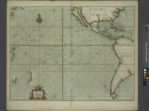
The first Europeans to reach the western edge of the Pacific were Portuguese explorers in 1512. They sailed to the Maluku Islands (also known as the Spice Islands). In 1513, another Portuguese explorer, Jorge Álvares, reached southern China.
The eastern side of the ocean was first seen by a Spanish explorer named Vasco Núñez de Balboa in 1513. He crossed the Isthmus of Panama and found a new ocean. He called it Mar del Sur, which means "Sea of the South," because it was south of where he first saw it.

In 1520, the explorer Ferdinand Magellan and his crew were the first to cross the Pacific Ocean. They were on a Spanish journey to the Spice Islands. Magellan named the ocean Pacífico, meaning "peaceful." He chose this name because after sailing through very stormy seas near Cape Horn, they found calm waters. For a long time, people called it the Sea of Magellan to honor him. Magellan's expedition completed the first trip around the world in 1522, even though he died in the Philippines in 1521.
Later, Spanish ships sailed from Mexico and Peru to the Philippines, establishing important trade routes. The Manila galleons, for example, sailed between Manila and Acapulco for 250 years. Spanish explorers also found many islands in the South Pacific, like Tuvalu and the Solomon Islands.
Dutch explorers also made important discoveries. Willem Janszoon was the first European to make a documented landing in Australia in 1606. Later, Abel Tasman explored and landed on parts of Australia, and discovered Tasmania and New Zealand in 1642.
In the 1700s, more countries began exploring the Pacific. Russians explored Alaska and the Aleutian Islands. The French explored and settled in Polynesia. The British explorer James Cook made three famous voyages to the South Pacific, Australia, Hawaii, and North America. These voyages greatly increased our knowledge of the Pacific.
Modern History and Changes
.jpeg)

During the 1800s, many European countries, along with Japan and the United States, took control of islands in Oceania. Important scientific trips also happened, like the voyages of HMS Beagle with Charles Darwin in the 1830s.
By 1900, most Pacific islands were controlled by Britain, France, the United States, Germany, Japan, and Chile. After World War II, many of these islands became independent countries.
Geography of the Pacific

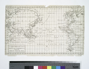
The Pacific Ocean separates the continents of Asia and Australia from the Americas. We can divide it into the North Pacific (above the equator) and the South Pacific (below the equator). It stretches from the cold Antarctic region in the south to the Arctic in the north.
The Pacific Ocean covers about 165.2 million square kilometers (63.8 million square miles). This is larger than all of Earth's land combined! It is about 15,500 kilometers (9,600 miles) long from north to south. Its widest point is about 19,800 kilometers (12,300 miles) across, from Indonesia to Colombia. That's more than five times the diameter of the Moon!
The deepest known point on Earth is the Mariana Trench, which is in the Pacific Ocean. It goes down about 10,911 meters (35,797 feet) below sea level. The average depth of the Pacific is about 4,280 meters (14,040 feet).
The Pacific Ocean is slowly shrinking by about 2.5 centimeters (1 inch) each year. This is because of the movement of the Earth's tectonic plates. In contrast, the Atlantic Ocean is actually growing larger.
Many seas are found along the edges of the Pacific Ocean. Some of the largest include the Celebes Sea, Coral Sea, East China Sea, Philippine Sea, Sea of Japan, South China Sea, Sulu Sea, Tasman Sea, and Yellow Sea. The Pacific is connected to the Indian Ocean by the Indonesian Seaway and to the Atlantic Ocean by the Drake Passage and the Strait of Magellan. To the north, the Bering Strait connects it to the Arctic Ocean.
Even though Magellan called it "peaceful," the Pacific Ocean is not always calm. Many tropical storms hit the islands. The areas around the Pacific, known as the Pacific Ring of Fire, have many volcanoes and are often affected by earthquakes. Tsunamis, which are giant waves caused by underwater earthquakes, have caused a lot of damage to islands and towns.
Countries and Territories Around the Pacific


Independent Nations
 Argentina
 Australia
 Brunei
 Cambodia
 Canada
 Chile
Chile China1
 Colombia
 Costa Rica
 Ecuador
 El Salvador
 Federated States of Micronesia
 Fiji
Fiji Guatemala
 Honduras
 Indonesia
 Japan
Japan Kiribati
 North Korea
 South Korea
 Malaysia
 Marshall Islands
 Mexico
 Nauru
Nauru Nicaragua
 New Zealand
 Palau
Palau Panama
 Papua New Guinea
 Peru
Peru Philippines
 Russia
 Samoa
Samoa Singapore
 Solomon Islands
 Taiwan1
 Thailand
 Timor-Leste
 Tonga
Tonga Tuvalu
 United States
 Vanuatu
 Vietnam
1 The status of Taiwan and China is disputed. For more information, see political status of Taiwan.
Territories
 (US)
(US) Baker Island (US)
 Clipperton Island (France)
 Cook Islands (New Zealand)
 Coral Sea Islands (Australia)
 French Polynesia (France)
 Guam (US)
 Hong Kong (China)
- Howland Island (US)
- Jarvis Island (US)
- Johnston Island (US)
- Kingman Reef (US)
 Macau (China)
- Midway Atoll (US)
 New Caledonia (France)
 Niue (New Zealand)
 Norfolk Island (Australia)
 (US)
(US)- Palmyra Atoll (US)
 Pitcairn Islands (UK)
 Tokelau (New Zealand)
 Wallis and Futuna (France)
- Wake Island (US)
Images for kids
-
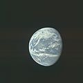
Partial picture of the Pacific Ocean from space, by the Apollo 11 crew.
-
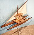
Model of a Fijian drua, a type of catamaran used by Austronesian peoples.
-
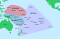
Regions, island nations, and territories of Oceania.
-
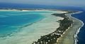
Tarawa Atoll in the Republic of Kiribati.
-
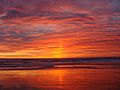
Sunset in Monterey County, California, U.S.
-
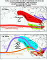
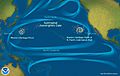
Impact of El Niño and La Niña on North America.
-
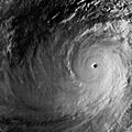
Typhoon Tip at its strongest on October 12, 1979.
-
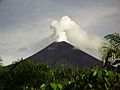
Ulawun stratovolcano on the island of New Britain, Papua New Guinea.
-
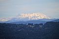
Mount St. Helens in 2020.
-
Pacific Ocean currents have created 3 "islands" of debris.
-
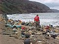
Marine debris on a Hawaiian coast.
-
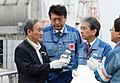
Prime Minister Suga declined to drink the bottle of Fukushima's treated radioactive water that he was holding, which would otherwise be discharged to the Pacific. 2020.
.jpg)


_peak_intensity.jpg)


See also
 In Spanish: Océano Pacífico para niños
