
List of capitals in the United States facts for kids


This article is about the capital cities of the United States. It includes places that are or have been the main cities for the federal government, states, territories, colonies, and Native American nations.
Washington, D.C. has been the main capital of the United States since 1800. Each of the U.S. states has its own capital city. Many U.S. territories also have capital cities. Most states have kept the same capital city since they became a state. However, the capital cities of the colonies or territories before them often changed many times. There were also other governments within the current U.S. borders with their own capitals. Examples include the Republic of Texas and Native American nations.
Contents
The United States' Main Capitals

.jpg)

The cities listed below were official capitals of the United States. This was either under the U.S. Constitution or before it was created. Before the Constitution, the Second Continental Congress or the Congress of the Confederation met in these places. The United States did not have a permanent capital under the Articles of Confederation.
The U.S. Constitution was approved in 1787. It gave Congress the power to choose a special area for the government's home. In 1790, Congress passed the Residence Act. This law set up the national capital along the Potomac River. This area became Washington, D.C.. For the next ten years, Philadelphia was the temporary capital. Congress met there at Congress Hall. On November 17, 1800, the U.S. Congress officially started meeting in Washington, D.C.
Congress has met outside Washington only two times since then. These meetings were mostly for ceremonies. One was in Philadelphia in 1987 to celebrate 200 years of the Constitution. The other was in New York in 2002 to remember the September 11 attacks.
| City | Building | Start Date | End Date | How Long |
|---|---|---|---|---|
| Second Continental Congress | ||||
| Philadelphia, Pennsylvania | Independence Hall | July 4, 1776 | December 12, 1776 | 5 months and 8 days |
| Baltimore, Maryland | Henry Fite House | December 20, 1776 | February 27, 1777 | 2 months and 7 days |
| Philadelphia, Pennsylvania | Independence Hall | March 5, 1777 | September 18, 1777 | 6 months and 13 days |
| Lancaster, Pennsylvania | Court House | September 27, 1777 | September 27, 1777 | 1 day |
| York, Pennsylvania | Court House (now Colonial Court House) | September 30, 1777 | June 27, 1778 | 8 months and 28 days |
| Philadelphia, Pennsylvania | College Hall of the University of Pennsylvania | July 2, 1778 | July 13, 1778 | 11 days |
| Philadelphia, Pennsylvania | Independence Hall | July 14, 1778 | March 1, 1781 | 2 years, 7 months and 15 days |
| Congress of the Confederation | ||||
| Philadelphia, Pennsylvania | Independence Hall | March 2, 1781 | June 21, 1783 | 2 years, 3 months and 19 days |
| Princeton, New Jersey | Nassau Hall | June 30, 1783 | November 4, 1783 | 4 months and 5 days |
| Annapolis, Maryland | Maryland State House | November 26, 1783 | August 19, 1784 | 8 months and 24 days |
| Trenton, New Jersey | French Arms Tavern | November 1, 1784 | December 24, 1784 | 1 month and 23 days |
| New York, New York | Federal Hall | January 11, 1785 | October 6, 1788 | 3 years, 11 months and 5 days |
| New York, New York | Walter Livingston House | October 6, 1788 | March 3, 1789 | 4 months and 25 days |
| United States Congress | ||||
| New York, New York | Federal Hall | March 4, 1789 | December 5, 1790 | 1 year, 9 months and 1 day |
| Philadelphia, Pennsylvania | Congress Hall | December 6, 1790 | May 14, 1800 | 9 years, 5 months and 8 days |
| Washington, D.C. | United States Capitol | November 17, 1800 | August 24, 1814 | 13 years, 9 months and 7 days |
| Washington, D.C. | Blodgett's Hotel | September 19, 1814 | December 7, 1815 | 1 year, 2 months and 18 days |
| Washington, D.C. | Old Brick Capitol | December 4, 1815 | March 3, 1819 | 3 years, 2 months and 27 days |
| Washington, D.C. | United States Capitol | March 4, 1819 | Present | 207 years and 23 days |
State Capitals
Each U.S. state has a capital city. This city is where the state government is located. Ten of the first thirteen states and 15 other states have changed their capital city at least once. The last state to move its capital was Oklahoma in 1910.
In the table below, the "Since" column shows when the city became the capital. This could be for the state or for an earlier territory. The population numbers are from the 2020 U.S. Census. Areas colored light yellow are smaller "micropolitan" areas.
| State | Capital | Since | Area | Population (2020 US Census) | City Rank in State | ||
|---|---|---|---|---|---|---|---|
| City | MSA/µSA | CSA | |||||
| Alabama | Montgomery | 1846 | 159.8 sq mi (414 km2) | 200,603 | 386,047 | 476,207 | 3 |
| Alaska | Juneau | 1906 | 2,716.7 sq mi (7,036 km2) | 32,255 | 32,255 | 3 | |
| Arizona | Phoenix | 1912 | 517.6 sq mi (1,341 km2) | 1,608,139 | 4,845,832 | 4,899,104 | 1 |
| Arkansas | Little Rock | 1821 | 116.2 sq mi (301 km2) | 202,591 | 748,031 | 912,604 | 1 |
| California | Sacramento | 1854 | 97.9 sq mi (254 km2) | 524,943 | 2,397,382 | 2,680,831 | 6 |
| Colorado | Denver | 1867 | 153.3 sq mi (397 km2) | 715,522 | 2,963,821 | 3,623,560 | 1 |
| Connecticut | Hartford | 1875 | 17.3 sq mi (45 km2) | 121,054 | 1,213,531 | 1,482,086 | 4 |
| Delaware | Dover | 1777 | 22.4 sq mi (58 km2) | 39,403 | 181,851 | 7,379,700 | 2 |
| Florida | Tallahassee | 1824 | 95.7 sq mi (248 km2) | 196,169 | 384,298 | 8 | |
| Georgia | Atlanta | 1868 | 133.5 sq mi (346 km2) | 498,715 | 6,089,815 | 6,930,423 | 1 |
| Hawaii | Honolulu | 1845 | 68.4 sq mi (177 km2) | 350,964 | 1,016,508 | 1 | |
| Idaho | Boise | 1865 | 63.8 sq mi (165 km2) | 235,684 | 764,718 | 850,341 | 1 |
| Illinois | Springfield | 1837 | 54.0 sq mi (140 km2) | 114,394 | 208,640 | 308,523 | 7 |
| Indiana | Indianapolis | 1825 | 361.5 sq mi (936 km2) | 887,642 | 2,111,040 | 2,492,514 | 1 |
| Iowa | Des Moines | 1857 | 75.8 sq mi (196 km2) | 214,133 | 709,466 | 890,322 | 1 |
| Kansas | Topeka | 1856 | 56.0 sq mi (145 km2) | 126,587 | 233,152 | 5 | |
| Kentucky | Frankfort | 1792 | 14.7 sq mi (38 km2) | 28,602 | 75,393 | 746,045 | 15 |
| Louisiana | Baton Rouge | 1880 | 76.8 sq mi (199 km2) | 227,470 | 870,569 | 2 | |
| Maine | Augusta | 1832 | 55.4 sq mi (143 km2) | 18,899 | 123,642 | 10 | |
| Maryland | Annapolis | 1694 | 6.73 sq mi (17 km2) | 40,812 | 2,844,510 | 9,973,383 | 7 |
| Massachusetts | Boston | 1630 | 89.6 sq mi (232 km2) | 675,647 | 4,941,632 | 8,466,186 | 1 |
| Michigan | Lansing | 1847 | 35.0 sq mi (91 km2) | 112,644 | 541,297 | 5 | |
| Minnesota | Saint Paul | 1849 | 52.8 sq mi (137 km2) | 311,527 | 3,690,261 | 4,078,788 | 2 |
| Mississippi | Jackson | 1821 | 104.9 sq mi (272 km2) | 153,701 | 591,978 | 671,607 | 1 |
| Missouri | Jefferson City | 1826 | 27.3 sq mi (71 km2) | 43,228 | 150,309 | 15 | |
| Montana | Helena | 1875 | 14.0 sq mi (36 km2) | 32,091 | 83,058 | 6 | |
| Nebraska | Lincoln | 1867 | 74.6 sq mi (193 km2) | 291,082 | 340,217 | 361,921 | 2 |
| Nevada | Carson City | 1861 | 143.4 sq mi (371 km2) | 58,639 | 58,639 | 657,958 | 6 |
| New Hampshire | Concord | 1808 | 64.3 sq mi (167 km2) | 43,976 | 153,808 | 8,466,186 | 3 |
| New Jersey | Trenton | 1784 | 7.66 sq mi (20 km2) | 90,871 | 387,340 | 23,582,649 | 10 |
| New Mexico | Santa Fe | 1610 | 37.3 sq mi (97 km2) | 87,505 | 154,823 | 1,162,523 | 4 |
| New York | Albany | 1797 | 21.4 sq mi (55 km2) | 99,224 | 899,262 | 1,190,727 | 6 |
| North Carolina | Raleigh | 1792 | 114.6 sq mi (297 km2) | 467,665 | 1,413,982 | 2,106,463 | 2 |
| North Dakota | Bismarck | 1883 | 26.9 sq mi (70 km2) | 73,622 | 133,626 | 2 | |
| Ohio | Columbus | 1816 | 210.3 sq mi (545 km2) | 905,748 | 2,138,926 | 2,544,048 | 1 |
| Oklahoma | Oklahoma City | 1910 | 620.3 sq mi (1,607 km2) | 681,054 | 1,425,695 | 1,498,149 | 1 |
| Oregon | Salem | 1855 | 45.7 sq mi (118 km2) | 175,535 | 433,353 | 3,280,736 | 3 |
| Pennsylvania | Harrisburg | 1812 | 8.11 sq mi (21 km2) | 50,099 | 591,712 | 1,295,259 | 9 |
| Rhode Island | Providence | 1900 | 18.5 sq mi (48 km2) | 190,934 | 1,676,579 | 8,466,186 | 1 |
| South Carolina | Columbia | 1786 | 125.2 sq mi (324 km2) | 136,632 | 829,470 | 951,412 | 2 |
| South Dakota | Pierre | 1889 | 13.0 sq mi (34 km2) | 14,091 | 20,745 | 9 | |
| Tennessee | Nashville | 1826 | 525.9 sq mi (1,362 km2) | 689,447 | 1,989,519 | 2,118,233 | 1 |
| Texas | Austin | 1839 | 305.1 sq mi (790 km2) | 961,855 | 2,283,371 | 4 | |
| Utah | Salt Lake City | 1858 | 109.1 sq mi (283 km2) | 199,723 | 1,257,936 | 2,701,129 | 1 |
| Vermont | Montpelier | 1805 | 10.2 sq mi (26 km2) | 8,074 | 59,807 | 285,369 | 6 |
| Virginia | Richmond | 1780 | 60.1 sq mi (156 km2) | 226,610 | 1,314,434 | 4 | |
| Washington | Olympia | 1853 | 16.7 sq mi (43 km2) | 55,605 | 294,793 | 4,953,421 | 23 |
| West Virginia | Charleston | 1885 | 31.6 sq mi (82 km2) | 48,864 | 258,859 | 779,969 | 1 |
| Wisconsin | Madison | 1838 | 68.7 sq mi (178 km2) | 269,840 | 680,796 | 910,246 | 2 |
| Wyoming | Cheyenne | 1869 | 21.1 sq mi (55 km2) | 65,132 | 100,512 | 1 | |
Capitals of U.S. Territories
An insular area is a U.S. territory that is not part of a state or Washington, D.C. Some of these territories have their own capital cities.
| Territory | Capital | Since | Population (2010) | Notes |
|---|---|---|---|---|
| American Samoa | Pago Pago | 1899 | 3,656 | Pago Pago is a group of villages. One of them, Fagatogo, is the official government center. |
| Guam | Hagåtña | 1898 | 1,051 | Dededo is the largest village in Guam. |
| Northern Mariana Islands | Saipan | 1947 | 48,220 | The whole island of Saipan is considered the capital. Most government offices are in Capitol Hill village. |
| Puerto Rico | San Juan | 1898 | 395,326 | San Juan is the oldest capital city in the U.S. that has been continuously lived in. |
| U.S. Virgin Islands | Charlotte Amalie | 1917 | 18,481 | Charlotte Amalie is on the island of Saint Thomas. The territorial government directly runs it. |
Past National Capitals
Two of the 50 U.S. states, Hawaii and Texas, were once independent countries. They had their own capital cities.
Hawaii's Capitals
Hawaii was an independent nation (Kingdom of Hawaii, 1795–1893; Republic of Hawaii, 1894–1898). Five different places served as its capital:

- Waikīkī, 1795–1796
- Hilo, 1796–1803
- Honolulu, 1803–1812
- Kailua-Kona, 1812–1820
- Lahaina, 1820–1845
- Honolulu, 1845–1898
The United States took over Hawaii in 1898. Honolulu stayed the capital. First, it was the capital of the Territory of Hawaii (1900–1959). Then, it became the capital of the state of Hawaii (since 1959).
Texas's Capitals
Texas was an independent nation (Republic of Texas, 1836–1845). Seven different places served as its capital:
- Washington (now Washington-on-the-Brazos), 1836
- Harrisburg (now part of Houston), 1836
- Galveston, 1836
- Velasco, 1836
- West Columbia, 1836
- Houston, 1837–1839
- Austin, 1839–1845
The United States took over Texas in 1845. Austin is still the capital of the state of Texas today.
Native American Capitals

Some Native American tribes, like the Five Civilized Tribes, set up their governments with constitutions and capitals, similar to Western countries. Other groups, like the Iroquois, had long-standing traditions of a main meeting place, or 'capitol' longhouse. Since these nations worked with the U.S. government, their capitals were recognized in some ways.
Cherokee Nation Capitals
- New Echota 1825–1832
New Echota, near Calhoun, Georgia, was founded in 1825. It was the dream of Cherokee Chief Major Ridge. He chose the spot because it was central to the historic Cherokee Nation. This nation covered parts of Georgia, North Carolina, Tennessee, and Alabama. The town had a Council House, Supreme Court, and a printing press for the Cherokee syllabary. New Echota was the capital until 1832. At that time, Georgia made laws against Native American meetings to weaken the Nation.

- Red Clay 1832–1838
The Cherokee National council grounds moved to Red Clay, Tennessee. This was done to avoid the Georgia state militia. Red Clay was the capital until the Cherokee Nation was forced to move to Indian Territory (Oklahoma). This sad journey is known as the Trail of Tears.
- Tahlequah 1839–1907, 1938–present
Tahlequah, in present-day Oklahoma, became the capital of the original Cherokee Nation after the forced move. After the Civil War, the Cherokee Nation built a new brick National Capitol in Tahlequah. This building was the capital until 1907. Then, the Dawes Act broke up the Cherokee Nation. Tahlequah became the county seat of Cherokee County, Oklahoma. The Cherokee National government was restarted in 1938. Tahlequah is still the capital of the modern Cherokee Nation. It is also the capital of the United Keetoowah Band of Cherokee Indians.
- Cherokee 20th century–present (Eastern Band of Cherokee)
Some Cherokees avoided the forced removal. They lived on a separate piece of land in the Smoky Mountains of North Carolina. Their descendants formed the Eastern Band of Cherokee Indians. Their capital is at Cherokee, North Carolina.
Muscogee Creek Nation Capitals
- Hot Springs, Arkansas c. 1837–1866
After being moved from their homeland, the Creek government met near Hot Springs. This area was part of their new territory. Because some Creeks fought with the Confederacy during the American Civil War, the Union forced them to give up half of their land.
- Okmulgee 1867–1906
Okmulgee became the National capital after the Civil War. It was likely named after Ocmulgee in Georgia.
Iroquois Confederacy Capital
- Onondaga (Onondaga privilege c. 1450–present)
The Iroquois Confederacy, also called the Haudenosaunee, is an alliance of six Native American nations in upstate New York. These nations include the Seneca, Cayuga, Onondaga, Oneida, Mohawk, and Tuscarora. Since the Confederacy started around 1450, the Onondaga Nation has hosted the Iroquois Grand Council. They are the "Keepers of the Fire and the Wampum." They still do this at the official Longhouse on the Onondaga Reservation. The Six Nations of the Haudenosaunee keep this tradition alive today. They say it is the "world's oldest representative democracy."
Seneca Nation of Indians Capitals
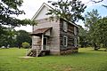
The Seneca Nation was founded in 1848. It has two capitals that switch roles every two years. Jimerson Town was created in the 1960s.
Window Rock is a small city in Arizona. It is the government center and capital of the Navajo Nation (1936–present). The Navajo Nation is the largest territory of a Native American nation in North America. Window Rock has the Navajo Nation Council, Supreme Court, and offices for the President and Vice President.
Unrecognized National Capitals
There have been some self-declared nations within the U.S. borders that were never officially recognized as independent. However, these nations did control their areas for a time.
Colonies of British America

Before the United States became independent from Great Britain in 1776, several meetings were held for some of the colonies. These meetings did not talk about independence. So, they did not name a national capital. The Second Continental Congress was meeting when the U.S. declared independence. But it had not yet set up a permanent national capital.
| City | Building | Start Date | End Date | How Long |
|---|---|---|---|---|
| Albany Congress | ||||
| Albany, New York | Stadt Huys | June 19, 1754 | July 11, 1754 | 22 days |
| Stamp Act Congress | ||||
| New York, New York | City Hall | October 7, 1765 | October 25, 1765 | 23 days |
| First Continental Congress | ||||
| Philadelphia, Pennsylvania | Carpenters' Hall | September 5, 1774 | October 26, 1774 | 1 month and 21 days |
| Second Continental Congress | ||||
| Philadelphia, Pennsylvania | Independence Hall | May 10, 1775 | July 4, 1776 | 1 year, 1 month and 24 days |
Vermont Republic Capital
Before joining the United States as the 14th state, Vermont was an independent republic. It was called the Vermont Republic (1777–1791). Three cities served as its capital:
- Westminster, 1777
- Windsor, 1777–?
- Castleton, ?–1791
The current capital of the State of Vermont is Montpelier.
State of Franklin Capitals
The State of Franklin was an independent territory. It was created after the American Revolution from land that later became part of Tennessee. Franklin was never officially part of the U.S. and only existed for four years.
- Jonesborough, Tennessee, 1784–1785
- Greeneville, Tennessee, 1785–1788
State of Muskogee Capital
The State of Muskogee was a Native American state in Spanish Florida. It was created by an Englishman named William Augustus Bowles. It included several tribes of Creeks and Seminoles. It existed from 1799 to 1803. It had one capital:
- Miccosukee, 1799–1803
Republic of West Florida Capital
The Republic of West Florida was a short-lived nation that broke away from Spanish West Florida in 1810. It included parts of modern-day Louisiana, Mississippi, and Alabama. The U.S. claimed this area was part of the Louisiana Purchase. Within two months, U.S. President James Madison sent forces to take over the new republic peacefully. It became part of the U.S. in 1812. During its short time, the capital was:
Republic of Indian Stream Capital
The Republic of Indian Stream was an unrecognized independent nation in what is now New Hampshire.
- The area that would become Pittsburg, New Hampshire, 1832–1835
California Republic Capital
Before the U.S. took over California in 1848, a small part of northern California declared itself the California Republic in 1846. This was an act of independence from Mexico. The republic only lasted a month before it joined the American army. Its land later became part of the U.S.


The California Republic was never recognized by the U.S., Mexico, or any other nation. Its flag, with a California grizzly bear and a star, became known as the Bear Flag. It was later used as the basis for California's official state flag.
There was one main capital for the California Republic:
- Sonoma, 1846
Confederate States Capitals

The Confederate States of America (C.S.A.) had two capitals during its existence. The first capital was in Montgomery, Alabama, starting February 4, 1861. It moved to Richmond, Virginia, on May 29, 1861.
The individual state capitals in the Confederacy stayed the same as they were in the Union. However, as the Union Army advanced, some Confederate state governments moved or left their states.
- Montgomery, Alabama, February 4, 1861 – May 29, 1861
- Richmond, Virginia, May 29, 1861 – April 3, 1865
Free State of Jones Capital
In 1863 and 1864, Jones County, Mississippi rebelled against Confederate rule. It became almost independent under the name Free State of Jones. The Free State fought battles with Confederate troops. By spring 1864, the rebels controlled the county. They raised an American flag over the courthouse in Ellisville. They sent a letter to Union General William T. Sherman declaring their independence from the Confederacy.
Historians disagree on whether the county truly seceded. There isn't enough information to be sure. The rebellion in Jones County has been called everything from small local fights to a full war for independence.
Historical State and Colonial Capitals
Most of the original Thirteen Colonies had their capitals attacked by the British during the American Revolutionary War. State governments operated wherever they could. For example, New York City was held by British troops from 1776 to 1783. Similar events happened during the War of 1812, the American Civil War, and the Pueblo Revolt in New Mexico (1680–1692).
Twenty-two state capitals have been capitals for longer than their state has existed. This is because they were also capitals for earlier territories, colonies, or republics. Boston, Massachusetts, has been a capital city since 1630. It is the oldest continuously running capital in the United States. Santa Fe, New Mexico, is the oldest capital city overall. It became a capital in 1610 and was only interrupted by the Pueblo Revolt. An even older Spanish city, St. Augustine, Florida, was a colonial capital from 1565 until about 1820. That's over 250 years!
Images for kids
-
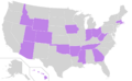
States (highlighted in purple) whose capital city is also their most populous
-
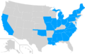
States (highlighted in blue) that have changed their capital city at least once
-
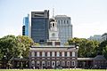
The Second Continental Congress and the Congress of the Confederation met at Independence Hall at various times between 1775 and 1782, and the U.S. Congress met at the adjacent Congress Hall in the 1790s.
-

Federal Hall memorial in New York City: in an earlier building on this site, the United States Congress convened for the first time under the United States Constitution in 1789 and George Washington was sworn in as the first president
-
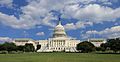
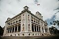
The west front of the current United States Capitol in Washington, D.C.
-
Honolulu twice served as the national capital of Hawaii and is now the state capital.
-
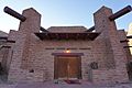
The Navajo Nation Council Chamber in Window Rock, Arizona is the center of government for the Navajo Nation
-
The New Echota Council House (since reconstructed)
-
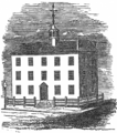
Stadt Huys, the original city hall of Albany, New York and meeting place of the Albany Congress in 1754.
-
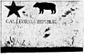
The original of Todd's Bear Flag, photographed in 1890
-
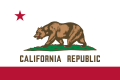
Modern flag of the State of California
-
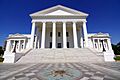
Richmond served as the second capital of the Confederate States of America. The city has been Virginia's capital since 1780.
-
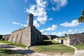
St. Augustine, Florida served as Florida's capital from 1565 until the 1820s.

See Also
 In Spanish: Anexo:Capitales en los Estados Unidos para niños
- History of the United States
- List of largest cities of U.S. states and territories by population
- List of state and territorial capitols in the United States
- List of states and territories of the United States
- Lists of capitals
- Outline of United States history
- Territorial evolution of the United States
- Territories of the United States
