
History of Oklahoma facts for kids

The history of Oklahoma is all about the past of the state of Oklahoma and the land it now covers. Much of Oklahoma was bought by the United States in 1803 as part of the Louisiana Purchase. The part known as the Oklahoma Panhandle was added later, after the Mexican–American War (1846–1848).
Most of this land was set aside as Indian Territory. Its borders were mostly formed in 1834. This area was opened for new settlers around 1890. People who arrived before this official opening were called "Sooners". From 1890 to 1907, the area was known as Oklahoma Territory. Oklahoma became the 46th state on November 16, 1907. In its early years, Oklahoma was mostly a state for ranching and farming. Oil also became a very important part of its economy.
Historians David Baird and Danney Goble say that Oklahomans share a history of hope, new ideas, and courage. They believe the people of Oklahoma are known for being optimistic, creative, and brave.
Contents
- Oklahoma's Early Land and People
- Oklahoma and Indian Territories Become One
- Becoming a State
- Oklahoma After Statehood
- Oklahoma During World War II
- Oklahoma After World War II
- Images for kids
Oklahoma's Early Land and People

Oklahoma sits between the Great Plains and the Ozark Plateau. The western part of the state often has long dry spells and strong winds. These winds can create dust storms. The eastern part of Oklahoma has a humid, warm climate. A "dry line" often crosses the state. This line separates moist air from the east and dry desert air from the west. This line was important for early settlements. Farmers settled in the east, while Hunter-gatherer tribes lived in the west.
Ancient Times: Before AD 1500

People have lived in what is now Oklahoma for a very long time. The oldest known groups, called Paleo-Indians, lived here thousands of years ago. Their tools and hunting sites have been found all over the state.
The first European to visit this area was a Spanish explorer named Hernando de Soto. He met many groups who spoke Caddoan languages. These included the Caddo, Wichita, Pawnee, and Kichai tribes.
The Caddoan Mississippian Culture

Between AD 800 and 1450, a group of cultures called the Mississippian culture lived in the central and southeastern United States, including eastern Oklahoma. These groups were farmers. They often built ceremonial mounds and burial mounds. They traded with each other by traveling on rivers. There were many small chiefdoms, but none controlled huge areas for long.
The Caddoan Mississippian culture grew from earlier groups. By AD 800, Caddoan society started to form. Some villages became important centers for ceremonies. They had special homes for leaders and built mounds around open areas called plazas. These plazas were kept clean and used for special events. The Caddoan people were on the edge of the Mississippian world. They shared traits with both Mississippian and Plains cultures. Their communities were not as big or as protected as others. They also did not have large, complex chiefdoms, except maybe at the Spiro Mounds. As religious and social ideas grew, some families became more important. This is shown by large tombs with special items that showed power and respect, like those found at Spiro.
Wichita Plains Culture

Archaeologists believe the ancestors of the Wichita people lived on the eastern Great Plains for at least 2,000 years. These early Wichita were hunters and gatherers. Over time, they learned to farm. From 900 to 1400 AD, many farming villages thrived in central and western Oklahoma.
Around 900 AD, farming villages appeared along the Washita and South Canadian Rivers. People in these villages grew corn, beans, squash, and tobacco. They hunted deer, rabbits, and bison. They also fished and collected mussels. These villagers lived in rectangular houses made of thatch. Their population grew, with villages of up to 20 houses spread out along the rivers.
By 1500, Apache groups also began moving into Wichita areas of Oklahoma. It seems the two groups lived together peacefully for some time. The Wichita in southwestern Oklahoma also traded regularly with tribes in what is now Texas and New Mexico.
Kiowa-Apache Culture

The Kiowa and Apache tribes have a close history. Both were hunter-gatherers. They used dogs to carry their belongings as they moved to hunt. Both tribes seem to have come from the Southwest thousands of years ago. Then, they moved north. Later, both migrated from Canada back to the Southwest. This was around the time Francisco Coronado explored the Southwest and brought horses. Both tribes learned to use horses in their cultures.

However, their languages are very different. The Apache are a Southern Athabaskan group. They traditionally lived on the Southern Plains of North America. The Kiowa are part of a Tanoan group. Tanoan languages were spoken in pueblos in New Mexico. Language experts believe the Kiowa language separated from the Tanoan branch over 3,000 years ago. Then, the Kiowa moved far north.

The Kiowa and Apache adopted similar ways of life. But they remained different tribes. Instead of learning each other's language, they used Plains Indian Sign Language to talk. The Kiowa and Plains Apache lived in the plains near the Arkansas River in Colorado and Kansas. They also lived in the Red River area of the Texas Panhandle and western Oklahoma.
The Kiowas had a well-organized tribal government. Like most tribes on the Northern Plains, they had a yearly Sun Dance gathering. They also had a chief who led the whole tribe. Kiowa society included warrior groups and religious groups.
Historically, Apache culture was similar to the Pueblo peoples. But when the Spanish took control, traditional trade between tribes was broken. The Pueblo people were forced to work on Spanish mission lands. The Apache quickly got horses. This made them more mobile for quick raids on settlements.
European Claims: Louisiana (New France)

In 1682, René-Robert Cavelier, Sieur de La Salle claimed the entire Mississippi River and its connecting rivers for France. This meant the land that would become Oklahoma was under French control from 1682 to 1763. It was part of a large territory called Louisiana (New France). France mostly focused on settling areas further north and along the Mississippi River. Oklahoma remained untouched by French settlers.
After the Seven Years' War (also called the French and Indian War in North America), France had to give up the eastern part of this territory to Britain in 1763. This was part of the Treaty of Paris. Interestingly, France had already secretly given the entire territory to Spain in 1762. This was done in the Treaty of Fontainebleau. The transfer to Spain was not announced until 1764. Spain did not argue about Britain taking the eastern part of French Louisiana. Spain wanted the western part, which was next to its colony of New Spain.
Spain focused its settlement efforts on New Orleans. So, Oklahoma remained free from European settlement during Spanish rule. In 1800, France secretly got the western Louisiana territory back. But Napoleon Bonaparte was busy with problems in Europe. He decided to sell the territory to the United States.
The Louisiana Purchase and Arkansas Territory

In 1803, the United States bought 828,000 square miles of land from France. This was called the Louisiana Purchase. It included the lands drained by the Mississippi River (west of the river) and the Missouri River. This huge purchase covered all or part of 15 future U.S. states, including all of Oklahoma. It also included parts of two Canadian provinces.
From the Louisiana Purchase, two new territories were created: Louisiana Territory and Orleans Territory. Orleans Territory became the state of Louisiana in 1812. Louisiana Territory was renamed Missouri Territory to avoid confusion.

Arkansas Territory was formed from the southern part of Missouri Territory in 1819. Its southern border was set at 36°30' north latitude. This included all of present-day Oklahoma south of that line. When Missouri became a state in 1821, the remaining territorial lands became unorganized. On November 15, 1824, and again on May 6, 1828, parts of western Arkansas Territory were removed. This made Arkansas Territory the same size as the present state of Arkansas. The new western border of Arkansas was meant to go straight south from Missouri's western border to the Red River. However, during talks with the Choctaw in 1820, Andrew Jackson accidentally gave them more Arkansas Territory land than he realized. Then in 1824, the Choctaw agreed to move further west, but only a short distance from Belle Point. This created the bend in the Arkansas/Oklahoma border near Fort Smith.
The Adams–Onís Treaty and New Spain

The Adams–Onís Treaty of 1819 was an agreement between the United States and Spain. Spain gave the Florida Territory to the U.S. The U.S. gave some western areas to Spain. The treaty also set the boundary between the U.S. and New Spain. This new border started at the Sabine River from the Gulf of Mexico north to the 32nd parallel north. Then it went north to the Red River, west along the Red River to the 100th meridian west. From there, it went north to the Arkansas River, west to its source, north to the 42nd parallel north, and finally west to the Pacific Ocean. This was sometimes called the "Step Boundary."
This treaty set the southern (Red River) and main western (100th meridian west) borders of the future state of Oklahoma. It was also through this treaty that the land that became the Oklahoma Panhandle was separated from the rest of the future state and given to the Spanish government.
The Forced Relocation of Native Americans

In the early days of the United States, a big challenge was how to manage new settlements on Native American lands. One idea was to move tribes to unsettled land further west. In 1820 and 1825, the Choctaw were given lands in Arkansas Territory (including parts of present-day Oklahoma). This was in exchange for some of their homeland, mostly in Mississippi.
This idea became official in 1830 with the Indian Removal Act. This law gave President Andrew Jackson the power to make treaties with Native American tribes living east of the Mississippi River. The treaties asked Native Americans to give up their eastern land for land in the west. Those who wanted to stay had to become citizens in their state. For tribes that agreed, the move was peaceful. But those who resisted were eventually forced to leave.
Part of what became Oklahoma was chosen as the new home for the "Five Civilized Tribes". This area was later called Indian Country or Indian Territory. The goal was to provide plenty of land for Native Americans from eastern states who did not want to change their way of life.
The Choctaw were the first of the "Five Civilized Tribes" to be moved from the southeastern United States. In September 1830, Choctaws in Mississippi agreed to a treaty and got ready to move west. The phrase "Trail of Tears" first described the Choctaw Nation's removal in 1831. However, the term is most often used for the Cherokee removal in 1838-39.
The Creek tribe refused to move at first. They signed a treaty in March 1832. This treaty opened up a large part of their land. In return, they were promised protection for their remaining lands. But the United States did not protect the Creeks. In 1837, they were forced to move by the military without signing another treaty.
The Chickasaw saw that moving was unavoidable. They signed a treaty in 1832 that included protection until their move. But the Chickasaws were forced to move early. This was because white settlers moved onto their lands, and the War Department did not protect them.
In 1833, a small group of Seminoles signed a relocation treaty. But most of the tribe said the treaty was not valid. This led to the Second (1835–42) and Third Seminole Wars (1855-58). Those who survived the wars were eventually paid to move west.
The Treaty of New Echota of 1835 gave the Cherokees in Georgia two years to move west. If they didn't, they would be forced. After two years, only 2,000 Cherokees had moved. 16,000 remained on their lands. The U.S. sent 7,000 soldiers to force the Cherokee to move. They were not given time to gather their belongings. This march west is known as the Trail of Tears. About 4,000 Cherokee people died during this journey.
Texas and Kansas Territories

In 1821, New Spain became independent and was called the Mexican Empire. Later, it became the Mexican Republic in 1824. So, Mexico now owned the lands south and west of the U.S. territories. Texas, a part of Mexico, declared its independence in 1836 after the Texas Revolution. The Republic of Texas was a separate country from 1836 to 1845.
Texas joined the United States as a state in 1845. The Mexican–American War followed from 1846-1848. The war ended with the Treaty of Guadalupe Hidalgo. In this treaty, the U.S. gained lands that Texas had claimed from Mexico. This included the Oklahoma Panhandle. It also gained lands west of the Rio Grande to the Pacific Ocean. Texas becoming a state was a big political issue. It added another "slave state" to the Union. The conditions for its statehood were not settled until the Compromise of 1850. One condition was that Texas had to set its northern border at 36°30' north. This was part of the Missouri Compromise. Texas also had to give up its claim to parts of New Mexico east of the Rio Grande. In return, the U.S. took on Texas's $10 million debt.
On May 30, 1854, the Kansas and Nebraska Territories were created from the Indian Territory. The southern border of Kansas Territory was set at the 37th parallel north. This line became the northern border of the future state of Oklahoma. This also created an empty strip of land between Kansas's southern border and the northern border of the Texas Panhandle (at 36°30' north). This neutral strip was called "No Man's Land". It eventually became the Oklahoma Panhandle.
The Civil War in Indian Territory
In 1860, the Indian Territory had about 55,000 Native Americans, 8,400 Black slaves owned by Native Americans, and 3,000 white people. When the American Civil War began in 1861, Texas forces moved north. The United States removed its military from the territory. A Confederate official named Albert Pike signed agreements with all the major tribes. The territories even sent a representative to the Confederate Congress.
However, some groups opposed the Confederacy. This led to a small Civil War within the territory. Union troops and loyal Native Americans attacked Indian Territory. They won an important battle at Honey Springs on July 17, 1863. By late summer 1863, Union forces controlled Fort Smith in Arkansas. Confederate hopes of keeping control of the territory ended. Many pro-Confederate Cherokee, Creek, and Seminole people fled south. They became refugees among the Chickasaw and Choctaws. But Confederate General Stand Watie, a Cherokee, kept fighting. He was the last Confederate general to surrender, on June 23, 1865.
After the Civil War, a law was passed. It said the President could stop funding any tribe that was "in a state of actual hostility" to the U.S. government. The President could also declare all treaties with that tribe to be canceled.
After the Civil War
In 1866, the U.S. government made new treaties with the tribes that had sided with the Confederacy. These were called Reconstruction Treaties. Most of the land in central and western Indian Territory was given to the government. Some land went to other tribes. But the central part, called the Unassigned Lands, stayed with the government. Another agreement allowed railroads to cross Native American lands. Also, slavery was made illegal. Some nations welcomed their former slaves. But others were very unfriendly to them and wanted them to leave their territory. During this time, the government's policy changed. It shifted from moving Native Americans to trying to make them adopt American ways of life.
In the 1870s, white and Black people wanted to settle the government lands in Indian Territory. They wanted to do this under the Homestead Act of 1862. They called the Unassigned Lands Oklahoma. They called themselves "Boomers". In 1884, a court ruled that settling on these lands was not a crime. The government first resisted, but Congress soon passed laws allowing settlement.
In the 1880s, early settlers in the very empty Panhandle region tried to form their own territory. They called it the Cimarron Territory. But they lost a lawsuit against the government. A judge then accidentally gave the area a nickname. He said, "That is land that can be owned by no man." After that, the panhandle was called "No Man's Land" until Oklahoma became a state.
Congress passed the Dawes Act in 1887. This law required the government to make agreements with tribes. The goal was to divide tribal lands into individual plots for Native Americans. Any leftover tribal lands would be surveyed and opened for settlement by non-Native Americans. After settlement, many white people accused Republican officials of favoring former slaves in land disputes.
The Land Run of 1889


The United States made two new treaties with the Creeks and Seminoles. These treaties said the tribes would sell some of their land in Oklahoma to the U.S. This land was for other Native American tribes and former slaves. This land became known as the Unassigned Lands or Oklahoma Country in the 1880s. It remained empty for over ten years.
In 1879, Elias Cornelius Boudinot, who was part Cherokee, argued that these Unassigned Lands should be open for settlement. He said the U.S. owned these lands. He also pointed out that the government no longer wanted to settle Native Americans and Black people on these lands. He noted that Black people were now U.S. citizens.
On March 23, 1889, President Benjamin Harrison signed a law. This law opened up two million acres of the Unassigned Lands for settlement on April 22, 1889. This was the first of many "land runs". Later land openings were done by lottery. This was because many settlers cheated. Some settlers were called "Sooners" because they had already claimed their land before it was officially opened.
Oklahoma and Indian Territories Become One

Indian Territory (lands owned by the Five Civilized Tribes and other tribes from east of the Mississippi River) and Oklahoma Territory (lands set aside for Plains Indians and other Midwestern tribes, plus the recently settled "Unassigned Lands" and the Neutral Strip) were officially created by Congress on May 2, 1890. This was done through the Oklahoma Organic Act. An Organic Act is a law Congress uses to create organized territories. These territories are expected to become states later. For the next 16 years, Congress passed laws to join Oklahoma and Indian territories into a single state.
More Land Runs (1891-1895)
In 1893, the government bought the right to settle the Cherokee Outlet, also called the Cherokee Strip, from the Cherokee Nation. This land was part of what the Cherokees gave up in the 1866 treaty. But the Cherokees still had access to it. They had leased it to Chicago meat-packing companies for large cattle ranches. The Cherokee Strip was opened for settlement by a land run in 1893.
Also in 1893, Congress created the Dawes Commission. Its job was to make agreements with each of the Five Civilized Tribes. These agreements would divide tribal lands into individual plots for Native Americans. Finally, the Curtis Act of 1898 took away the tribes' power over all of Indian Territory.
Historian Angie Debo wrote a famous book called And Still the Waters Run: The Betrayal of the Five Civilized Tribes (1940). It showed how the Dawes Commission's policy of dividing land was used to unfairly take land and resources from Native Americans.
Oklahoma is well-known for its frontier history. This history is famously shown in the 1943 Broadway musical Oklahoma! and its 1955 movie version. The musical is based on a 1931 play. It takes place in Oklahoma Territory near Claremore in 1906.
Becoming a State
In 1902, leaders in Indian Territory wanted to become their own state. They wanted to name it Sequoyah. They held a meeting in Eufaula. Representatives from the Cherokee, Choctaw, Chickasaw, Muscogee (Creek), and Seminole tribes attended. These were the Five Civilized Tribes. They met again the next year to create a state constitution.
The Sequoyah Convention and Statehood Attempt
The Sequoyah Constitutional Convention met in Muskogee on August 21, 1905. Pleasant Porter, the Principal Chief of the Muscogee Creek Nation, was chosen as president. The delegates decided that the leaders of the Five Civilized Tribes would also be vice-presidents. These included William Charles Rogers (Cherokee), William H. Murray (Chickasaw), Green McCurtain (Choctaw), John Brown (Seminole), and Charles N. Haskell (Creek).
The convention wrote a constitution. They planned how the government would work. They also drew out proposed county lines for the new state. Then, they chose delegates to go to the United States Congress. Their job was to ask for statehood. If this had happened, Sequoyah would have been the first state with a majority Native American population.
The people of Indian Territory strongly approved the convention's plans in a vote in 1905. However, the U.S. government was not keen on Indian Territory and Oklahoma Territory becoming separate states. They preferred them to become one state.
Murray's Idea for One State

William H. Murray, known for being smart about politics, saw this coming. When he was asked to represent the Chickasaw Nation for Sequoyah's statehood attempt, he predicted it would fail in Washington, D.C.. He suggested that if it failed, Indian Territory should work with Oklahoma Territory to become one state. President Theodore Roosevelt and Congress rejected the idea of two separate states.
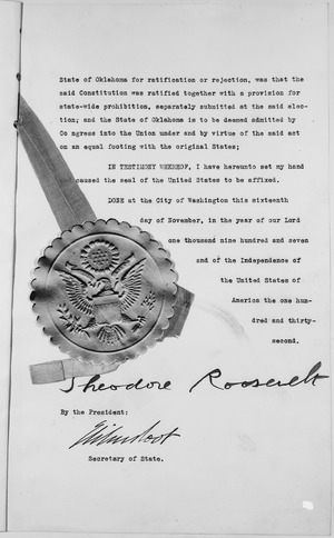
Seeing a chance for statehood, Murray and Haskell suggested another convention. This one would be for both territories combined, named Oklahoma. In 1906, the Oklahoma Enabling Act was passed by Congress and approved by President Roosevelt. This law set out specific rules for the new state's constitution. Haskell and Murray used the Sequoyah constitution as a base for most of the new state constitution. They then returned to Washington with the proposal for statehood. On November 16, 1907, President Theodore Roosevelt signed the paper. This made Oklahoma the 46th state in the nation.
Oklahoma After Statehood
The early years of statehood were very active in politics. In 1910, the Democrats moved the state capital to Oklahoma City. This was three years before the Oklahoma Organic Act allowed it. They wanted to move away from Guthrie, which was a Republican stronghold.
Socialism became popular among struggling farmers. Oklahoma had the largest Socialist population in the U.S. at that time. The Socialist vote doubled in every election until the U.S. entered World War I in 1917. However, the war caused food prices to rise, which helped farmers. So, the movement faded away. By the 1920s, the Republican Party gained control in the state. The economy kept getting better, especially in cattle ranching, cotton, wheat, and oil. Throughout the 1920s, new oil fields were found. Oklahoma produced over 1.8 billion barrels of oil, worth over $3.5 million, in that decade.
Oil Discoveries

The first oil well in the United States was finished in July 1850 in the old Cherokee Nation. But the oil business really took off in the early 1900s. Huge amounts of oil were found underground in places like Glenpool near Tulsa. Many white people came to Oklahoma to make money. Many of Oklahoma's wealthy families today trace their beginnings to this time.
Throughout the 1920s, more oil fields were found. Oklahoma produced over 1.8 billion barrels of oil, worth over $3.5 million, in that decade. In 1920, the amazing Osage County oil field opened. Then in 1926, the Greater Seminole Oil Field opened. When the Great Depression hit, Oklahoma and Texas oil flooded the market. Prices fell to pennies a gallon. In 1931, Governor William H. Murray decided to act. He used the National Guard to shut down all of Oklahoma's oil wells. This was an effort to make prices stable again. National policy then used the Texas Railroad Commission to set limits in Texas. This also helped raise prices for Oklahoma oil.
Prosperous 1920s
The wealth of the 1920s can still be seen in buildings from that time. Examples include the Tulsa mansion that became the Philbrook Museum of Art. Also, there is the art deco architecture in downtown Tulsa.
Black Communities
The early 1900s were a time of political change in Oklahoma. Many different groups moved into the state. "Black towns," or towns made up of African Americans who chose to live separately from white people, grew all over the state. Most of the state followed Jim Crow laws. These laws separated people by race, with a bias against non-white people. Greenwood, a neighborhood in Northern Tulsa, was known as "Black Wall Street". This was because it had a lively business, cultural, and religious community. In 1921, this area was the site of the Tulsa Race War. This was one of the deadliest race riots in U.S. history.
Many all-Black towns started in early Oklahoma. However, many have disappeared. Here are some that still exist today:
| Town Name | County | 2010 Census Population | Notes |
|---|---|---|---|
| Boley | Okfuskee | 1,184 | 39.6% black alone in 2010 |
| Brooksville | Pottawatomie | 63 | 20.0% black alone in 2010 |
| Clearview | Okfuskee | 48 | 75% black alone in 2010 |
| Grayson | Okmulgee | 59 | 53% African American alone in 2010 |
| Langston | Logan | 1,724 | 93.2% black alone in 2010 |
| Lima | Seminole | 53 | 34.0% African American alone in 2010 |
| Redbird | Wagoner | 137 | 67.9% black alone in 2010 |
| Rentiesville | McIntosh | 128 | 50.0% black alone in 2010 |
| Summit | Muskogee | 139 | 75.5% African American alone in 2010 |
| Taft | Muskogee | 250 | 82.0% African American alone in 2010 |
| Tatums | Carter | 151 | 79.5% black alone in 2010 |
| Tullahassee | Wagoner | 106 | 63.2% black alone in 2010 |
| Vernon | McIntosh | N. A. | Unincorporated community |
Socialist Movement in Oklahoma
The Oklahoma Socialist Party was very successful during this time. It had the most members per person in Oklahoma, with 12,000 members in 1914. They published many newspapers and elected hundreds of local officials. Much of their success came from reaching out to Black and Native American voters. They were the only party to keep fighting against Jim Crow laws. They also changed some of their ideas to fit Oklahoma better. For example, they supported many small farms and used religion to spread their message. The state party also helped presidential candidate Eugene V. Debs get some of his highest votes in the nation.
The party later almost disappeared. This happened during a time of fear after the Green Corn Rebellion and World War I. People who spoke against the war or capitalism were often targeted.
Governor Walton's Impeachment
Unhappy farmers and workers in Oklahoma easily elected Jack C. Walton, a left-wing Democrat, as governor in 1922. Many scandals followed. Walton's actions included questionable spending, pardoning prisoners, removing college leaders, and greatly increasing his own salary. Conservative groups successfully asked for a special meeting of the legislature to remove him. To fight back, Walton attacked Oklahoma's Ku Klux Klan. He banned parades, declared martial law (military rule), and hired outsiders to "keep the peace." He declared martial law in the entire state. He even tried to use the National Guard to stop the legislature from meeting. That failed. Lawmakers accused Walton of corruption, removed him from office in 1923.
The Great Depression and Dust Bowl
The Great Depression lasted from 1929 to the late 1930s. Times were very hard, especially from 1930-1933. Prices for oil and farm products dropped sharply, but debts remained high. Many banks and businesses went out of business. The Depression was made much worse in parts of the state by the Dust Bowl conditions. Farmers were hit the hardest. Many moved to cities and lived in poor communities called Hoovervilles.
This time also led to a large move of people to California. These people were called "Okies" (a negative term used in California). They went looking for a better life. This image was made famous by John Steinbeck's novel, The Grapes of Wrath. The book, with photos by Dorothea Lange, and songs by Woody Guthrie, told sad stories from this time. Many Oklahomans were offended by the negative image of "Okies" as poor, rootless workers. These stories often mixed the experiences of former sharecroppers with those fleeing the dust storms of the High Plains. Most people, both those who stayed and those who left Oklahoma, faced great poverty during the Depression. Grapes of Wrath showed a powerful but simple view of the complex problems in rural Oklahoma. It didn't mention that most people stayed in Oklahoma.
The federal Agricultural Adjustment Act paid farmers to grow less. This caused prices to rise, and the worst of the hardship ended.

Short periods of dry weather and bad farming methods led to the Dust Bowl. Huge dust storms blew away soil from large areas of farmland. This soil landed on nearby farms or even far away. The crops failed, forcing many small farmers to leave the state. The worst dust storms were in the Panhandle. But much of the state had occasional dusters, dry spells, and very hot weather. Towns like Alva, Altus, and Poteau all recorded temperatures of 120 °F (49 °C) during the very hot summer of 1936.
Oklahoma During World War II
By 1940, Oklahoma's economy was clearly getting better. Farm and cattle prices rose. So did the price of oil. Huge amounts of federal money spent on roads and buildings during the Depression also started to help. Even before World War II began, Oklahoma's industries saw more demand for their products. The federal government built defense facilities. These included the Oklahoma Ordnance Works near Pryor and the Douglas Aircraft plant near the Tulsa Municipal Airport. Many air bases were built across Oklahoma.
Robert S. Kerr, who was governor from 1943-1946, was an oilman. He supported President Roosevelt's New Deal programs. He used his connections in Washington to get federal money for Oklahoma. The state built and expanded many army and navy bases and airfields. This brought thousands of good-paying jobs. Kerr later became a powerful Senator (1949–1963). He looked out for Oklahoma's interests, especially for the oil and gas industry.
Oklahoma was often among the top 10 states in selling war bonds. People used exciting events, friendly competition, door-to-door visits, and direct appeals to big businesses. This helped build patriotism and state pride. It also encouraged people to save some of their high wartime wages, which they couldn't spend much due to rationing and shortages. Schoolchildren, housewives, and retired men helped with the bond drives. This made everyone feel like they were directly helping the war effort.
Oklahoma After World War II
In recent years, the term "Okie" has changed meaning. Many Oklahomans, both past and present, now wear the label with pride. They see it as a symbol of the "Okie survivor attitude." However, some people who lived during the Dust Bowl still see the term negatively. They view the "Okie" migrants as people who gave up and moved to the West Coast.
After the Depression, major changes in Oklahoma history included the rise of tribal sovereignty. This meant tribes could issue their own car license plates. They also opened tribal smoke shops, casinos, grocery stores, and other businesses. Other trends were the fast growth of suburbs around Oklahoma City and Tulsa. The population in Western Oklahoma dropped. There was an oil boom in the 1980s and an oil bust in the 1990s.
Recently, state and local leaders have worked hard to help Oklahoma's small towns and population centers. Many had seen a big decline after the oil bust. But Oklahoma City and Tulsa are still active economically. They are working to have more diverse industries. The state is focusing more on medical research, health, finance, and manufacturing.
Aeronautical Industry Focus
Besides government and education jobs, the largest employers in Oklahoma are often in the aviation industry. The building of Tinker Air Force Base and the FAA's Mike Monroney Aeronautical Center in Oklahoma City are important. American Airlines has an engineering center, maintenance facility, and data center in Tulsa. These give the state an advantage in the aviation part of the economy. AAR Corporation has operations in both Oklahoma City and Tulsa. The Boeing Company and Pratt & Whitney are also growing their presence near Tinker AFB.
The state has a strong military (Air Force) presence. There are bases in Enid, Oklahoma (Vance Air Force Base) and Altus, Oklahoma (Altus Air Force Base), in addition to Tinker AFB in Oklahoma City. Tinker also hosts the Navy's Strategic Communications Wing One.
For aviation education and training, Tulsa has the Spartan College of Aeronautics and Technology. It offers training in aviation and aircraft maintenance. Oklahoma University and Oklahoma State University both have aviation programs. The FAA's Academy trains Air Traffic Controllers.
Oil and Gas Industry Focus
The oil and natural gas industry has always been a major part of Oklahoma's economy. It is second only to agriculture. The Tulsa Metropolitan Area is home to traditional oil companies like ONEOK, Williams Companies, Helmerich & Payne, and Magellan Midstream Partners. ConocoPhillips also has a significant presence. Oklahoma City is home to energy companies such as Devon Energy, Chesapeake Energy, OGE Energy, SandRidge Energy, and Continental Resources. Duncan, Oklahoma is where Halliburton Corporation started. Oklahoma University's Mewbourne College of Earth and Energy does important research and education in this field.
HVAC Manufacturing Focus
Oklahoma has a surprisingly large number of companies that make products for heating and cooling buildings (HVAC). In Tulsa, there is AAON. In Oklahoma City, there are International Environmental, ClimateMaster, and Climate Control (which are part of LSB Industries). Also, Governair and Temptrol (part of CES Group) and York Unitary (part of Johnson Controls) have a big presence in the Oklahoma City area. Oklahoma State University does major research on developing the Geothermal heat pump. It is also the headquarters for the International Ground Source Heat Pump Association. Oklahoma State University–Okmulgee is known for its Air Conditioning Technology programs.
Oklahoma City Bombing
On April 19, 1995, the Alfred P. Murrah Federal Building in Oklahoma City was bombed. This tragic event caused many deaths. Timothy McVeigh and Terry Nichols were found responsible for the attack.
Images for kids
-
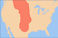
The Great Plains
-
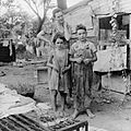
A mother and children during the Great Depression. Elm Grove, Oklahoma.
-
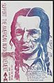
American Indian Movement poster from the civil rights era.


