
Geography of Russia facts for kids
Quick facts for kids Geography of Russia |
|
|---|---|
 |
|
| Continent | Europe and Asia |
| Region | Eastern Europe (European Russia) Northern Asia (Siberia) |
| Coordinates | 60°00′N 100°00′E / 60.000°N 100.000°E |
| Area | |
| • Land | 95.78% |
| • Water | 4.22% |
| Coastline | 37,654 km (23,397 mi) |
| Borders | Poland 204.1 km (126.8 mi) Lithuania 266 km (165 mi) |
| Highest point | Mount Elbrus 5,642 m (18,510 ft) |
| Lowest point | Caspian Sea, −28 m (−92 ft) |
| Longest river | Yenisei–Angara–Selenge, 5,539 km (3,442 mi) |
| Largest lake | Lake Baikal 31,722 km2 (12,248 sq mi) |
| Climate | European Russia and Siberia: mostly cool climate Extreme north: tundra Extreme southeast: temperate continental |
| Terrain | Most of Russia consists of two plains (the East European Plain and the West Siberian Plain), two lowlands (the North Siberian and the Kolyma, in far northeastern Siberia), two plateaus (the Central Siberian Plateau and the Lena Plateau to its east), and a series of mountainous areas mainly concentrated in the extreme northeast or extending intermittently along the southern border. |
| Natural Resources | Oil, gas, coal, timber, metals, diamonds, copper, lead, zinc, bauxite, nickel, tin, mercury, gold, silver, platinum, titanium, manganese, potash, uranium, cobalt, molybdenum, tungsten, aluminum, polymetals, chromium, phosphates, apatites, talc, asbestos, mica, salt, amber, precious and semiprecious stones, sand, clay, limestone, marble, granite, iron ore, arable land, tobacco, tea, citrus fruit, hydroelectricity, fresh water, fruits, and vegetables. |
| Natural Hazards | Earthquakes, landslides, storms, hurricanes, forest fires, and floods. |
| Environmental Issues | Deforestation, energy irresponsibility, pollution, and nuclear waste. |
Russia (Russian: Россия) is the largest country in the world. It covers a huge area of over 17,125,191 km2 (6,612,073 sq mi). This means it takes up more than one-eighth of all the land where people live on Earth! Russia is so big that it stretches across eleven different time zones. It also shares borders with more countries than any other nation, touching sixteen different countries.
Russia is a unique "transcontinental" country because it spreads across two continents: Europe and Asia. It covers the northern part of a huge landmass called Eurasia. Russia also has the fourth-longest coastline in the world, stretching for over 37,653 km (23,396 mi). Russia also has an additional 850 km (530 mi) of coastline along the Caspian Sea. The Caspian Sea is the world's largest inland body of water. It's sometimes called a sea and sometimes a lake! Russia is one of only three countries with a coast along three oceans. These are the Arctic, Pacific, and Atlantic (through the Baltic Sea). This gives Russia access to more than thirteen different seas. Imagine, Russia is even bigger than three whole continents. It has about the same surface area as the dwarf planet Pluto. Russia also has the largest forest area of any country in the world.
Contents
- Exploring Russia's Global Position and Borders
- Understanding Russia's Administrative Divisions
- Exploring Russia's Population and Cities
- Russia's Landscapes and Waterways
- Agriculture and Farming in Russia
- Russia's Climate Zones
- Russia's Area and Boundaries: Key Facts
- Russia's Natural Resources and Land Use
- Natural Hazards in Russia
- See also
Exploring Russia's Global Position and Borders
_(Russia_centered).svg)
Russia is incredibly vast. Its westernmost part, Kaliningrad Oblast, is about 9,000 km (5,600 mi) away from its easternmost part, Big Diomede Island in the Bering Strait. From north to south, the country spans about 4,500 kilometres (2,800 mi). This distance stretches from the northern tip of the Russian Arctic islands at Franz Josef Land to the southern tip of the Republic of Dagestan on the Caspian Sea. This huge area includes many different types of land, some of which are very difficult to live in.
Russia has the longest border in the world, extending for 57,792 kilometres (35,910 mi). Its land border is 20,139-kilometre (12,514 mi) long. Russia shares land with 14 countries: Poland and Lithuania (both through Kaliningrad Oblast), Norway, Finland, Estonia, Latvia, Belarus, Ukraine, Georgia, Azerbaijan, Kazakhstan, China, Mongolia, and North Korea.
About two-thirds of Russia's border is along the sea. Most of the long northern coast is far above the Arctic Circle. This coast is covered in ice for much of the year. However, the port of Murmansk stays open because of warmer ocean currents. Thirteen seas and parts of two oceans—the Arctic and Pacific—touch Russia's shores. Russia also shares a close sea boundary with Japan.
Understanding Russia's Administrative Divisions
Russia is divided into 83 main administrative areas called federal subjects. These include 22 republics, 9 territories (called krais), 46 provinces (called oblasts), 1 autonomous oblast, 4 autonomous districts (called okrugs), and 3 cities with special federal status: Moscow, Saint Petersburg, and Sevastopol. Russia considers Crimea as one of its republics, and Sevastopol as a federal city. However, many countries around the world recognize Crimea as part of Ukraine.
The republics are home to many different groups of people. These include northern Europeans, Tatars, Caucasus peoples, and native Siberians. The largest federal subjects are found in Siberia. The Sakha Republic (Yakutia) is the largest federal subject in Russia. It is twice the size of Alaska and the largest country subdivision in the world. Krasnoyarsk Krai, located west of Sakha, is the second largest. Kaliningrad Oblast is the smallest province and the smallest federal subject, except for the three federal cities. The two most populated federal subjects are Moscow Oblast (which includes Moscow) and Krasnodar Krai. Both are in European Russia.
Exploring Russia's Population and Cities
Russia's Population and People
According to the 2010 census, Russia had a population of about 141.18 million people. By 2021, this number had grown to around 146.2 million. This makes Russia the most populated country in Europe. It is also the ninth-most populated country in the world. On average, there are about 9 inhabitants per square kilometre (23 inhabitants/sq mi) per square kilometer.
Major Cities and Urban Life
-
Moscow, the capital and largest city of Russia
-
Saint Petersburg, the cultural capital and the second-largest city
-
Yekaterinburg, the fourth-largest city in the country.


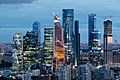
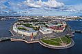
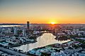
Russia is one of the world's most urbanized countries. About 75% of its total population lives in cities and towns. Moscow, the capital and largest city, has an estimated 12.4 million residents within its city limits. Over 17 million people live in its urban area, and more than 20 million in its wider metropolitan area. Moscow is among the world's largest cities. It is the most populated city entirely within Europe. It is also the most populated urban area and metropolitan area in Europe. Moscow is also the largest city by land area on the European continent. Saint Petersburg, known as the cultural capital, is the second-largest city. It has about 5.4 million inhabitants. Other major cities include Yekaterinburg, Novosibirsk, Kazan, Nizhny Novgorod, and Chelyabinsk.
| Rank | Pop. | |
|---|---|---|
| 1 | Moscow | 13,149,803 |
| 2 | Saint Petersburg | 5,597,763 |
| 3 | Novosibirsk | 1,633,851 |
| 4 | Yekaterinburg | 1,536,183 |
| 5 | Kazan | 1,318,604 |
| 6 | Krasnoyarsk | 1,205,473 |
| 7 | Nizhny Novgorod | 1,204,985 |
| 8 | Chelyabinsk | 1,177,058 |
| 9 | Ufa | 1,163,304 |
| 10 | Samara | 1,158,952 |
Russia's Landscapes and Waterways
Geographers usually divide Russia's huge territory into five natural zones. These are the tundra zone, the Taiga, or forest, zone, the steppe, or plains, zone, the arid zone, and the mountain zone. Most of Russia consists of two plains (the East European Plain and the West Siberian Plain). It also has three lowlands (the North Siberian, the Central Yakutian and the East Siberian). There are two plateaus (the Central Siberian Plateau and the Lena Plateau). Finally, there are two systems of mountainous areas. These are the East Siberian Mountains in far northeastern Siberia and the South Siberian Mountains along the southern border.
Russia's Diverse Ecoregions
-
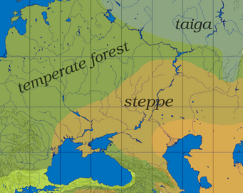
The wider area of the Urals, showing the transition of temperate forest, taiga, steppe and semi-desert
-
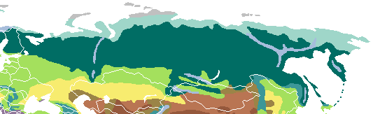 Ice sheet and polar desert Tundra Alpine tundra Taiga Montane forest Temperate broadleaf and mixed forest Temperate steppe Dry steppe


01. Tropical and subtropical moist broadleaf forests 02. Tropical and subtropical dry broadleaf forests 03. Tropical and subtropical coniferous forests 04. Temperate broadleaf and mixed forests 05. Temperate coniferous forests 06. Taiga and Boreal forest 07. Tropical and subtropical grasslands, savannas, and shrublands 08. Temperate grasslands, savannas, and shrublands 09. Flooded grasslands and savannas 10. Montane grasslands and shrublands 11. Tundra 12. Mediterranean forests, woodlands, and scrub 13. Deserts and xeric shrublands 14. Mangroves Rock and Ice, or Abiotic Land Zones
East European Plain: A Vast Expanse
The East European Plain covers most of European Russia. The West Siberian Plain, which is the world's largest, stretches east from the Urals to the Yenisei River. Because the land and plants are quite similar in each natural zone, Russia might seem uniform. However, Russia's territory has almost all the major plant zones found in the world, except for tropical rainforests.
The Icy World of Russia's Arctic and Tundra


The Russian Arctic stretches for almost 7,000 kilometres (4,300 mi) from west to east. It goes from Karelia and the Kola Peninsula to Nenetsia, the Gulf of Ob, the Taymyr Peninsula and the Chukchi Peninsula. Russian islands in the Arctic Sea include Novaya Zemlya, Severnaya Zemlya, and the New Siberian Islands.
About 10 percent of Russia is tundra. This is a treeless, marshy plain. The tundra is Russia's northernmost zone. It stretches from the Finnish border in the west to the Bering Strait in the east. Then it runs south along the Pacific coast to the northern Kamchatka Peninsula. This zone is famous for its herds of wild reindeer. It also has "white nights" in summer, where it's still light at midnight. In winter, there are days of total darkness.
The long, harsh winters and lack of sunshine mean only mosses, lichens, and dwarf willows and shrubs can grow low to the ground. The ground beneath is permanently frozen, called permafrost. Many powerful Siberian rivers flow through this zone to the Arctic Ocean. However, the ground thaws only partly, which creates many lakes, ponds, and swamps. Less than one percent of Russia's population lives here. The fishing and port industries of the Kola Peninsula are important. Huge oil and gas fields in northwestern Siberia are also major employers. Norilsk, with 180,000 people, is a large industrial city above the Arctic Circle. From here, you can also see the beautiful northern lights.
The Vast Taiga Forest Zone
Taiga is the most widespread natural area in Russia. It stretches from Russia's western borders all the way to the Pacific Ocean. It covers much of Eastern Europe and West Siberian plains. In Siberia, taiga forests reach Russia's southern borders. Overall, taiga accounts for over 60% of Russia's land.
The climate in the taiga is generally moist. Summers are moderately warm (or cool in the north), and winters are harsh. There is always a steady layer of snow in winter. The taiga is divided into northern, middle, and southern parts. In the western taiga, dense spruce and fir forests grow in wet areas. Pine forests, shrubs, and meadows grow on lighter soils. This type of plant life is also common in the eastern taiga, but larch trees are more important there than fir. The coniferous forest is not continuous. It has scattered areas of birch, alder, and willow (especially along rivers). Wet areas have marshes.
Many fur-bearing animals live in the taiga. These include sable, marten, ermine, moose, brown bear, Wolverine, wolf, and muskrat.

The soils in the taiga are mostly podzolic and cryogenic taiga soils. They have clear layers but are poor in humus. Groundwater is often close to the surface, washing away calcium from the top layers. This makes the topsoil discolored. Few areas of the taiga are good for farming. These are mainly in the European part of Russia. Large areas are covered by sphagnum marshes. To make the soil better for farming, lime and other fertilizers are needed.
Russian Taiga has the world's largest reserves of coniferous wood. However, these forests are harvested, and it's important to manage them carefully. Hunting and farming (mostly in river valleys) are also important activities here.
Mixed and Deciduous Forests

The mixed and deciduous forest belt is shaped like a triangle. It is widest along the western border and gets narrower towards the Ural Mountains. The main trees are oak and spruce. Many other plants grow here too, such as ash, aspen, birch, hornbeam, maple, and pine. East of the Urals, a narrow belt of birch and aspen woodland separates the taiga from the wooded steppe. Many parts of this forest zone have been used for farming over time, especially in European Russia. Because of this, wildlife is less common. However, the roe deer, wolf, fox, and squirrel are still very common.
The Grassy Steppe Plains
The steppe is often thought of as the typical Russian landscape. It is a wide band of treeless, grassy plains. These plains are sometimes broken up by mountain ranges. They stretch from Hungary across Ukraine, southern Russia, and Kazakhstan before ending in Manchuria. In a country of extremes, the steppe zone offers the best conditions for people to live and farm. This is because of its moderate temperatures and usually enough sunshine and moisture. Even here, however, farm harvests can be affected by unpredictable amounts of rain and occasional severe droughts. The soil in the steppe is very dry.
Russia's Mountain Ranges and Plains
.jpg)
Russia's mountain ranges are mainly found along its continental edge. These include the Ural Mountains. They are also along the southwestern border (the Caucasus). Other mountains are along the border with Mongolia (the eastern and western Sayan Mountains and the western part of the Altay Mountains). In eastern Siberia, there is a complex system of ranges in the northeastern corner of the country. These form the spine of the Kamchatka Peninsula. Smaller mountains extend along the Sea of Okhotsk and the Sea of Japan. Russia has nine major mountain ranges. Generally, the eastern half of the country is much more mountainous than the western half. The interior of the western half is mostly low plains. The Yenisei River valley is the traditional dividing line between the east and the west.
The Ural Mountains: A Natural Boundary

The Ural Mountains form a natural boundary between Europe and Asia. This mountain range stretches about 2,100 kilometres (1,300 mi) from the Arctic Ocean to the northern border of Kazakhstan. Several low passes in the Urals provide important routes for travel and trade from Europe to the east. The highest peak, Mount Narodnaya, is 1,894 metres (6,214 ft) tall. The Urals also contain valuable deposits of minerals.
The West Siberian Plain: A Flat and Wet Land

East of the Urals is the West Siberian Plain. It stretches about 1,900 kilometres (1,200 mi) from west to east and about 2,400 kilometres (1,500 mi) from north to south. More than half of this plain is below 200 metres (660 ft) in elevation. It contains some of the world's largest swamps and floodplains. The plain is mostly flat and has few distinct features. The only slightly higher areas are the Siberian Uvaly in the center and the Ob Plateau in the south. There are steppe areas in the southern part that reach into Kazakhstan, like the Ishim Steppe. Most of the plain's population lives in the drier southern section.
The Central Siberian Plateau: High and Rugged
The region directly east of the West Siberian Plain is the Central Siberian Plateau. It extends eastward from the Yenisei River valley to the Lena River valley. This region is divided into several plateaus, with elevations between 320 and 740 metres (1,050 and 2,430 ft). The highest point is about 1,800 metres (5,900 ft), found in the northern Putorana Mountains. The plain is bordered on the south by the Primorsky Range and the Baikal Mountains. To the north, it is bordered by the North Siberian Lowland, which extends into the Taymyr Peninsula on the Arctic Ocean.
Sayan and Stanovoy Mountains: Peaks and Valleys

In the mountain system west of Lake Baikal in south-central Siberia, there are very high peaks. The Western Sayan reach 3,300 metres (10,800 ft). The Eastern Sayan reach 3,200 metres (10,500 ft). Belukha Mountain in the Altay Mountains is 4,500 metres (14,800 ft) high. The Eastern Sayan mountains almost reach the southern shore of Lake Baikal. At the lake, there is a huge difference in elevation. The nearest mountain is 2,840 metres (9,320 ft) high, while the deepest part of the lake is 1,700 metres (5,600 ft) below sea level. The mountain systems east of Lake Baikal are lower. They form a complex of smaller ranges and valleys that reach from the lake to the Pacific coast. The Stanovoy Range, which runs west to east from northern Lake Baikal to the Sea of Okhotsk, has a maximum height of 2,550 metres (8,370 ft). To the south of that range is southeastern Siberia, where mountains reach 800 metres (2,600 ft). Across the Strait of Tartary from that region is Sakhalin Island, Russia's largest island. Its highest elevation is about 1,700 metres (5,600 ft). The small Moneron Island is located to its west.
The Caucasus Mountains: Europe's Highest Peaks

Truly alpine terrain, with sharp, high peaks, appears in the southern mountain ranges. Between the Black and Caspian seas, the Caucasus Mountains rise to impressive heights. They form a boundary between Europe and Asia. One of their peaks, Mount Elbrus, is the highest point in Europe, at 5,642 metres (18,510 ft). The geological structure of the Caucasus extends to the northwest as the Crimean and Carpathian Mountains. It also extends southeastward into Central Asia as the Tian Shan and Pamirs. The Caucasus Mountains create an imposing natural barrier between Russia and its neighbors to the southwest, Georgia and Azerbaijan.
Northeast Siberia and Kamchatka: Land of Volcanoes
Northeastern Siberia, north of the Stanovoy Range, is an extremely mountainous region. The long Kamchatka Peninsula sticks out southward into the Sea of Okhotsk. It includes many volcanic peaks, some of which are still active. The highest is the 4,750-metre (15,580 ft) Klyuchevskaya Sopka. This is the highest point in the Russian Far East. The chain of volcanoes continues from the southern tip of Kamchatka southward through the Kuril Islands chain and into Japan. Kamchatka is also one of Russia's two main areas of seismic activity (earthquakes). The other is the Caucasus. In 1995, a major earthquake largely destroyed the oil-processing town of Neftegorsk. This region also contains the very large Beyenchime-Salaatin crater.
Russia's Rivers and Lakes: A Watery Wonderland

Russia is home to over 100,000 rivers. It is divided into twenty watershed districts. Russia has one of the world's largest surface water resources. Its lakes contain about one-quarter of the world's liquid fresh water. Russia is second only to Brazil in total renewable water resources.
Forty of Russia's rivers that are longer than 1,000 kilometres (620 mi) are east of the Ural Mountains. These include the three major rivers that drain Siberia as they flow northward to the Arctic Ocean. They are the Irtysh-Ob system (totaling 5,380 kilometres or 3,340 miles), the Yenisey (5,075 kilometres or 3,153 miles), and the Lena (4,294 kilometres or 2,668 miles). These are among the world's longest rivers. The areas these river systems drain cover about eight million square kilometres (3.1 million square miles). They discharge nearly 50,000 cubic meters of water per second into the Arctic Ocean. Because these rivers flow northward, the areas where they start thaw before the areas downstream. This creates vast swamps, such as the 48,000-square-kilometre (19,000 sq mi) Vasyugan Swamp in the center of the West Siberian Plain. The same happens with other river systems, including the Pechora and the Northern Dvina in western Russia. It also happens with the Kolyma and the Indigirka in Siberia. About 10 percent of Russian territory is classified as swampland.
Russia's inland bodies of water are mostly a result of past glaciation (ice ages). Ladoga and Onega in northwestern Russia are two of the largest lakes in Europe. However, Lake Baikal is the largest and most famous of Russia's fresh water bodies. It is the world's deepest, purest, oldest, and most capacious fresh water lake. It contains over one-fifth of the world's fresh surface water. Many smaller lakes dot northern Russia and the Siberian plains. The largest of these are lakes Belozero, Topozero, Vygozero, and Ilmen in the country's northwest. Lake Chany is in southwestern Siberia.
A number of other rivers drain Siberia from eastern mountain ranges into the Pacific Ocean. The Amur River and its main tributary, the Ussuri, form a long part of the winding boundary between Russia and China. The Amur system drains most of southeastern Siberia. Three river basins drain European Russia. The Dnieper, which flows mainly through Belarus and Ukraine, starts in the hills west of Moscow. The 1,860-kilometre (1,160 mi) Don is the fifth-longest river in Europe. It starts in the Central Russian Upland south of Moscow and then flows into the Sea of Azov at Rostov-on-Don. The Volga is widely seen as Russia's national river because of its historical and cultural importance. It is the longest river in Europe. It rises in the Valdai Hills west of Moscow and flows southeastward for 3,510 kilometres (2,180 mi) before emptying into the Caspian Sea. The Volga system drains about 1.4 million square kilometres (540,000 sq mi). Western Russia's rivers have long been a vital transportation system, linked by several canals. The Volga remains the country's most commercial river, carrying about two-thirds of Russia's inland water traffic.
Agriculture and Farming in Russia
About one billion acres of land in Russia can be farmed. However, only about 0.1 percent is used for permanent agriculture. The landscapes in Russia have very different environments.
- Tundra landscapes cover most of the northern region. Conditions are harsh because of the cold climates. Plant life does not grow very well here, making farming difficult.
- Mountain ranges are spread throughout the region, such as the Ural Mountains. These mountains form a dividing line between European Russia and Asian Russia.
- European Russia also has the European plains, which extend about 3,200 kilometres (2,000 mi).
In 2016, about 9.4% of Russia's population worked in agriculture.
Russia's main export is grain, making up about 6% of the world's trade. Other exported products include fish and oil (3%), meals (2%), and meat (less than 1%).
Early Farming Practices
Agriculture has always been important for Russia. In earlier times, people worked the land to grow food.
Russia's Climate Zones


Russia's huge size and how far many areas are from the sea mean that a humid continental climate is common. This climate is found in most parts of the country, except for the tundra and the far southwest. Mountains in the south and east block warm air from the Indian and Pacific oceans. Meanwhile, the flat plains in the west and north allow Arctic and Atlantic air to influence the country.
Most of Northwest Russia and Siberia have a subarctic climate. This means extremely cold winters in the inner parts of Northeast Siberia (especially Sakha, where the Northern Pole of Cold is located). Record low temperatures of −71.2 °C or −96.2 °F have been recorded there. Winters are more moderate elsewhere. Russia's vast land along the Arctic Ocean and the Russian Arctic islands have a polar climate.
The coastal part of Krasnodar Krai on the Black Sea, especially Sochi, has a humid subtropical climate. This means mild and wet winters. Some coastal and inland strips of the North Caucasus also have this climate. In many parts of East Siberia and the Russian Far East, winter is dry compared to summer. Other parts of the country have more even rainfall throughout the year. Winter precipitation in most parts of the country usually falls as snow. The westernmost parts of Kaliningrad Oblast and some parts in the south of Krasnodar Krai and the North Caucasus have an oceanic climate. The region along the Lower Volga and Caspian Sea coast, as well as some southernmost parts of Siberia, have a semi-arid climate and an arid climate.
Throughout much of Russia, there are only two clear seasons: winter and summer. Spring and autumn are usually short periods of change between very low and very high temperatures. January is the coldest month (or February on the coastline). July is usually the warmest. Large temperature differences are common. In winter, temperatures get colder as you go from south to north and from west to east. Summers can be quite hot, even in Siberia.
Russia's Area and Boundaries: Key Facts
Area (excluding Crimea):
- Total: 17,098,242 km2 (6,601,668 sq mi)
- Land: 17,021,900 km2 (6,572,200 sq mi)
- Water: 79,400 km2 (30,700 sq mi)
Area - comparative:
Slightly larger than twice the size of Brazil
Land boundaries:
- Total (excluding Crimea): 19,917 km (12,376 mi)
Kaliningrad forms the westernmost part of Russia. It has no land connection to the rest of the country. It is bordered by Poland, Lithuania, and the Baltic Sea.
Crimea is a peninsula located on the Black Sea. Russia considers Crimea to be one of its federal subjects. However, many countries around the world recognize Crimea as part of Ukraine.
Border countries:
| Country | Length | |
|---|---|---|
| km | mi | |
| Norway | 195.8 | 121.7 |
| Finland | 1,271.8 | 790.3 |
| Estonia | 138 | 86 |
| Latvia | 270.5 | 168.1 |
| Lithuania | 266 | 165 |
| Poland | 204.1 | 126.8 |
| Belarus | 1,239 | 770 |
| Ukraine | 1,925.8 | 1,196.6 |
| Georgia | 875.5 | 544.0 |
| Azerbaijan | 372.6 | 231.5 |
| Kazakhstan | 7,512.8 | 4,668.2 |
| Mongolia | 3,485 | 2,165 |
| China | 4,209.3 | 2,615.5 |
| North Korea | 17 | 11 |
| Japan | water | |
| US | water | |
| Country | Length | |
|---|---|---|
| km | mi | |
| Abkhazia | 255.4 | 158.7 |
| South Ossetia | 70 | 43 |
| remaining border with Georgia | 365 | 227 |
Coastline excluding Crimea: 37,653 km (23,396 mi)
Maritime claims:
- Russian continental shelf: 200 m (660 ft) depth or to the depth of exploitation
- Exclusive economic zone: 7,566,673 km2 (2,921,509 sq mi) with 200 nmi (370.4 km; 230.2 mi)
- Territorial sea: 12 nmi (22.2 km; 13.8 mi)
Elevation extremes:
- Lowest point: Caspian Sea: −28 m (−92 ft)
- Highest point: Mount Elbrus: 5,642 m (18,510 ft)
Russia's Natural Resources and Land Use
Russia holds the greatest reserves of mineral resources of any country in the world. Even though these resources are plentiful, they are often in remote areas with extreme climates. This makes them expensive to mine. The country has the most mineral fuels. It may hold as much as half of the world's coal reserves and even larger reserves of petroleum. Coal deposits are found throughout the region, but the largest are in central and eastern Siberia. The most developed fields are in western Siberia, the northeastern European region, around Moscow, and in the Urals. Major petroleum deposits are in western Siberia and the Volga-Urals. Smaller deposits are found across the country.
Natural gas, a resource of which Russia holds about forty percent of the world's reserves, can be found along Siberia's Arctic coast. It is also in the North Caucasus and northwestern Russia. Major iron-ore deposits are located south of Moscow, near the Ukrainian border in the Kursk Magnetic Anomaly. This area has huge iron ore deposits that affect Earth's magnetic field. Smaller deposits are in other parts of the country. The Ural mountains hold small deposits of manganese. nickel, tungsten, cobalt, molybdenum and other elements used to make iron alloys are found in good amounts.
Russia also contains most of the nonferrous metals (metals that don't contain iron). Aluminium ores are scarce. They are found mainly in the Ural region, northwestern European Russia, and south-central Siberia. Copper is more abundant. Major reserves are in the Urals, the Norilsk area near the mouth of the Yenisey in eastern Siberia, and the Kola Peninsula. Another vast deposit east of Lake Baikal was developed after the Baikal-Amur Mainline (BAM) railroad was finished in 1989.
The North Caucasus, far eastern Russia, and the western edge of the Kuznetsk Basin in southern Siberia have many lead and zinc ores. These are often found with copper, gold, silver, and many other rare metals. Russia has one of the largest gold reserves in the world, mostly in Siberia and the Urals. Mercury deposits can be found in the central and southern Urals and in south-central Siberia.
Raw materials are also plentiful. These include potassium and magnesium salt deposits in the Kama River region of the western Urals. Russia also has one of the world's largest deposits of apatite in the central Kola Peninsula. Rock salt is found in the southwestern Urals and southwest of Lake Baikal. Surface deposits of salt are in salt lakes along the lower Volga Valley. Sulfur can be found in the Urals and the middle Volga Valley.
Eight percent of the land is used for arable farming. Four percent is for permanent pastures. Forty-six percent of the land is forests and woodland, and forty-two percent is used for other purposes.
A recent study using satellite images showed that Russia has 1,002 km2 (387 sq mi) of tidal flats. This makes it the 33rd ranked country in terms of tidal flat area.
Natural Hazards in Russia
Volcanic activity occurs in the Kuril Islands. Volcanoes and earthquakes are also natural hazards on the Kamchatka Peninsula.
See also
- Geography of the Soviet Union
- Geology of Russia
- History of Russia
- List of Russian explorers
- Territorial evolution of Russia
