
Netherlands facts for kids
Quick facts for kids
Netherlands
|
|||
|---|---|---|---|
|
|||
| Motto: | |||
| Anthem: Wilhelmus (Dutch) ("William") |
|||
|
Location of Netherlands (dark green)
– on the European continent (light green & dark grey) |
|||
| Sovereign state | Kingdom of the Netherlands | ||
| Before independence | Spanish Netherlands | ||
| Act of Abjuration | 26 July 1581 | ||
| Peace of Münster | 30 January 1648 | ||
| United Kingdom of the Netherlands | 16 March 1815 | ||
| Liberation Day | 5 May 1945 | ||
| Kingdom Charter | 15 December 1954 | ||
| Caribbean reorganisation | 10 October 2010 | ||
| Capital
and largest city
|
Amsterdam 52°22′N 4°53′E / 52.367°N 4.883°E |
||
| Government seat | The Hague | ||
| Official languages | Dutch | ||
|
|||
|
Recognised languages
|
|
||
| Ethnic groups
(2024)
|
|
||
| Religion
(2024)
|
|
||
| Demonym(s) | Dutch | ||
| Government | Unitary parliamentary constitutional monarchy | ||
|
• Monarch
|
Willem-Alexander | ||
| Rob Jetten | |||
| Legislature | States General | ||
| Senate | |||
| House of Representatives | |||
| European Parliament | |||
|
• Netherlands constituency
|
31 seats | ||
| Area | |||
|
• Total
|
41,865 km2 (16,164 sq mi) (134th) | ||
|
• Water (%)
|
18.41 | ||
| Highest elevation | 870 m (2,850 ft) | ||
| Population | |||
|
• 2025 census
|
|||
|
• Density
|
541/km2 (1,401.2/sq mi) (26th) | ||
| GDP (PPP) | 2026 estimate | ||
|
• Total
|
|||
|
• Per capita
|
|||
| GDP (nominal) | 2026 estimate | ||
|
• Total
|
|||
|
• Per capita
|
|||
| Gini (2021) | ▼ 26.4 low |
||
| HDI (2023) | very high · 8th |
||
| Currency | |||
| Time zone | |||
|
• Summer (DST)
|
|||
| Date format | dd-mm-yyyy | ||
| Driving side | right | ||
| Calling code | +31, +599 | ||
| Internet TLD | .nl, .bq | ||


.png)


The Netherlands is a country that is part of the Kingdom of the Netherlands. Most of it is in Western Europe, but some parts are in the Caribbean. Over 17 million people live there. To the north and west of the European part is the North Sea. Germany is to the east and Belgium is to the south. The Netherlands helped start the European Union. People from the Netherlands are called "Dutch". Their language is also called Dutch. The official capital is Amsterdam, but the government is in The Hague.
Contents
What Does "Netherlands" Mean?
The name "The Netherlands" means "the low lands". This is because the land is, on average, only about 1 meter above sea level. A big part of the country (one-third) is even below sea level!
Sometimes, people incorrectly call the country "Holland". Holland was a very rich area with two provinces in the western part of the Netherlands. This led to the mistake. Some people who don't live in western Holland don't like this name. The name "Holland" comes from old Dutch words meaning "wood lands".
A Brief History of the Netherlands
From Burgundy to Independence
At the end of the Middle Ages, dukes from Burgundy (now part of France) brought together seventeen areas. These areas were called the Netherlands. When a duke's daughter married Maximilian I, Holy Roman Emperor, the Netherlands became part of Spain.
In the 16th century, many Dutch people became Protestants. The King of Spain wanted everyone to be Roman Catholic. He decided that all Protestants should be killed. The Dutch people did not like this. In 1568, they started a war against Spain. This war lasted until 1648 and is called the Eighty Years' War. An important Dutch leader was William the Silent.
In 1648, the Netherlands and Spain made peace. The Dutch got to keep the areas they had won. The part of the Netherlands not won by the Dutch stayed with Spain. This part later became Belgium.
The Golden Age of the Netherlands
When the Netherlands became independent, it was special. Most European countries had kings, but the Netherlands was a republic. It had seven provinces, ruled by their big cities. These cities were run by rich citizens. The provinces were led by a stadtholder, a powerful man, but less powerful than other European kings.
In the 17th century, the Netherlands was one of the richest and most powerful countries. This time is called the Golden Age. The Dutch Empire had lands all over the world. The most important was the East Indies (now Indonesia). The Dutch also started New Netherland, which is now New York. The Netherlands often fought wars, especially against England in the Anglo-Dutch Wars. Michiel de Ruyter, a Dutch admiral, became a hero by defeating the English navy near London.
Changes and New Beginnings
In the 18th century, the Netherlands became poorer. Many blamed the stadtholders. In 1795, French armies attacked the Netherlands. The stadtholder, William V, had to escape to England. The Netherlands became the Batavian Republic and a democracy. But the French emperor Napoleon was not happy. In 1806, he made his brother Louis Bonaparte king. Louis became popular, but Napoleon was still not pleased. So, in 1810, the Netherlands became part of France.
In 1815, Napoleon was defeated. The Netherlands became independent again. European leaders wanted to make the Netherlands stronger. So, Belgium and Luxembourg were added. William I, William V's son, became king. But the Belgians did not like their Dutch king. In 1830, they revolted. After some fighting, France supported Belgium. In 1831, Belgium chose its own king and became independent.
Modern Netherlands: Voting and World Wars
Some people thought the Dutch king still had too much power. They wanted to vote for their government. In 1848, there were revolts in Europe. The Dutch king was worried. He let Johan Rudolf Thorbecke write a new constitution. From then on, people could vote. At first, only rich men could vote. From 1919, everyone could vote.
The Netherlands stayed neutral in World War I. They wanted to be neutral in World War II too. But in 1940, Germany invaded and took over the country. The Nazis started killing Jewish people. Anne Frank, a Jewish girl, hid with her family and wrote a diary. She died in a Nazi concentration camp, but her diary became famous.
In 1944, American, Canadian, Polish, and British armies freed the south of the Netherlands. They tried to cross the Rhine river in Operation Market Garden to free the rest, but they failed. The whole country was freed in May 1945. During the five years of Nazi rule, 250,000 people died.
After the war, Indonesia declared independence. The Dutch sent soldiers to fight. But other countries, like the United States, told the Dutch to leave. They finally did in 1949. After the war, the Netherlands became one of the richest countries. In 2004, the United Nations said it was the 5th best country to live in.
How the Netherlands is Governed

The Netherlands has been a constitutional monarchy since 1815. This means it has a king or queen, but their power is limited by a constitution. It has been a parliamentary democracy since 1848. Dutch politics tries to get everyone to agree on important issues.
The King and Prime Minister
.jpeg)
The monarch (currently King Willem-Alexander of the Netherlands) is the head of state. The King has limited powers. He is kept informed about government matters.
The executive power is held by the Council of Ministers. This group usually has 13 to 16 ministers. The head of government is the Prime Minister of the Netherlands. The Prime Minister is often the leader of the largest political party.
How Laws are Made
The government is responsible to the States General, which is the parliament. The parliament has two parts:
- The House of Representatives (lower house) has 150 members. They are chosen by direct vote every four years.
- The Senate (upper house) has 75 members. They are chosen by provincial assemblies. The Senate can reject laws but cannot change them.
Provinces of the Netherlands

The European part of the Netherlands has 12 provinces. Each province has its own capital city.
|
Caribbean Parts of the Netherlands
The Netherlands also includes three special municipalities in the Caribbean: Bonaire, Saba and Sint Eustatius. They are not part of any province. Together, they are known as the Caribbean Netherlands.
The Netherlands (both the European and Caribbean parts), along with Aruba, Curaçao, and Sint Maarten (also in the Caribbean), form a sovereign state called the Kingdom of the Netherlands.
When the Kingdom was formed in 1954, the Caribbean areas became part of the Netherlands Antilles. Suriname in South America was also part of it, but became independent in 1975. Aruba left the Antilles in 1986. Curaçao and Sint Maarten left in 2010. The remaining islands then became the Caribbean Netherlands, which is part of the main country.
Major Cities in the Netherlands
Here are the cities with over 100,000 people:


| Rank | City | Population | Province |
|---|---|---|---|
| 1 | Amsterdam | 780,000 | |
| 2 | Rotterdam | 611,000 | |
| 3 | The Hague | 500,000 | |
| 4 | Utrecht | 312,634 | |
| 5 | Eindhoven | 213,809 | |
| 6 | Tilburg | 203,492 | |
| 7 | Almere | 193,303 | |
| 8 | Groningen | 187,298 | |
| 9 | Breda | 173,299 | |
| 10 | Nijmegen | 164,165 | |
| 11 | Apeldoorn | 155,726 | |
| 12 | Enschede | 154,017 | |
| 13 | Haarlem | 151,853 | |
| 14 | Arnhem | 147,018 | |
| 15 | Amersfoort | 126,750 | |
| 16 | Dordrecht | 118,540 | |
| 17 | Zoetermeer | 118,020 | |
| 18 | Zwolle | 118,000 | |
| 19 | Leiden | 117,480 | |
| 20 | Maastricht | 116,200 | |
| 21 | Ede | 107,476 | |
| 22 | 's-Hertogenbosch | 102,220 | |
| 23 | Venlo | 100,271 |
Geography and Landscape

The European Netherlands covers about 41,543 square kilometers, including water. The land area is about 33,481 square kilometers. The Caribbean Netherlands is much smaller, about 328 square kilometers.
The Netherlands is a very flat country. About 26% of its land and 21% of its people are below sea level. In the southeast, there are some small hills, but they are not very high. Most of the land below sea level was created by digging up peat or by reclaiming land from the water. Since the 16th century, large areas called polders have been kept dry using dikes, canals, and pumps.
Rivers and Deltas
Much of the country was formed by the mouths of three large European rivers: the Rhine, the Meuse, and the Scheldt. The southwest is a river delta where these rivers meet the sea.
The Rhine, its main branch the Waal, and the Meuse divide the European Netherlands into north and south. These rivers were natural barriers in the past. They created a cultural difference between the north and south. Another important branch of the Rhine, the IJssel river, flows into Lake IJssel. This lake used to be a sea called the Zuiderzee. This river also marks a language difference. People northeast of the IJssel speak Dutch Low Saxon dialects, except in Friesland, which has its own language.
Protecting the Land from Floods

Over many centuries, the Dutch coastline has changed a lot because of natural disasters and human actions.
In 1287, the St. Lucia's flood killed over 50,000 people. It was one of the worst floods ever. The St. Elizabeth flood in 1421 destroyed a newly reclaimed polder. This created the Biesbosch tidal floodplains. In February 1953, a huge North Sea flood broke many dikes. More than 1,800 people drowned. After this, the Dutch government started the "Delta Works". This huge project built strong defenses against future floods. It took over 40 years to complete.

People's actions sometimes made floods worse. High swampland was drained for farms. This caused the fertile peat to shrink and the ground level to drop. To fix this, groundwater levels were lowered, which made the peat shrink even more. Also, until the 19th century, peat was dug up and used as fuel.
To fight floods, the Dutch built many defenses. In the first 1000 years AD, villages were built on hills called terps. Later, these hills were connected by dikes. In the 12th century, local groups called "waterschappen" (water boards) started. Their job was to control water levels and protect areas from floods. These groups still exist today. As the ground sank, dikes grew bigger and joined together. By the 13th century, windmills were used to pump water. Windmills later helped drain lakes, creating the famous polders.
In 1932, the Afsluitdijk (Closure Dike) was finished. It blocked the former Zuiderzee (Southern Sea) from the North Sea. This created the IJsselmeer (IJssel Lake). It was part of the larger Zuiderzee Works project. This project reclaimed 2,500 square kilometers of land from the sea.
The Delta Works Project

After the 1953 disaster, the Delta Works were built. This was a huge set of civil engineering projects along the Dutch coast. It started in 1958 and was mostly finished in 1997. The main goal was to reduce flood risk in South Holland and Zeeland. This was done by making 3,000 km of outer sea-dikes higher and 10,000 km of inner dikes stronger. They also closed off the sea estuaries of Zeeland. The Delta Works are considered one of the seven wonders of the modern world by the American Society of Civil Engineers.
Global warming is expected to cause sea levels to rise. The Netherlands is getting ready for this. A special Delta Commission has a plan to deal with a 1.10 meter sea-level rise and a 10 cm land height drop. The plan includes making dikes and dunes stronger with 1.30 meters of extra flood protection. Climate change might also change rainfall and river flow. To protect against river floods, the "Room for the River plan" is being used. This plan gives rivers more space to flow. It protects major cities and allows some areas to flood safely. People who lived in these "overflow areas" have moved to higher ground.
Climate Change and the Netherlands
The Netherlands is already affected by climate change. The average temperature rose by more than 2°C from 1901 to 2020. Climate change has led to more droughts and heatwaves. Because much of the Netherlands is low or reclaimed from the sea, it is very open to sea level rise.
The Netherlands has the fourth largest greenhouse gas emissions per person in the European Union. This is partly due to many cows. The Dutch government wants to lower emissions in the coming decades. The Netherlands is working on large "green recovery" plans with the European Union. A court case also made the country reduce emissions by 25% below 1990 levels. In 2021, CO2 emissions were down 14% compared to 1990. The government's goal is to reduce emissions by 49% in 2030.
Nature and Wildlife

The Netherlands has 21 national parks and hundreds of other nature reserves. Most are managed by Staatsbosbeheer (the national forestry and nature group) and Natuurmonumenten (a private group). The Wadden Sea in the north has tidal flats and wetlands. It is rich in different kinds of life and is a UNESCO World Heritage Nature Site. The Eastern Scheldt became a national park in 2002. It is the largest national park in the Netherlands.
The Netherlands has lost most of its original natural woods. They were cut down by 1871. Nitrogen pollution is a problem. The number of flying insects in the Netherlands has dropped by 75% since the 1990s.
Caribbean Islands' Nature
.jpg)
In the Lesser Antilles islands of the Caribbean, Curaçao, Aruba, and Sint Maarten are separate countries within the Kingdom of the Netherlands. Three other areas, Bonaire, Sint Eustatius, and Saba, are special municipalities. These islands have a tropical climate with warm weather all year.
- Bonaire is part of the ABC islands. These islands have a mix of volcanic and coral origins.
- Saba and Sint Eustatius are part of the SSS islands. They are volcanic and hilly. The highest point in the Netherlands and the entire Kingdom is Mount Scenery on Saba, at 887 meters.
People and Language

The Netherlands is a small country with many people. It is one of the most densely populated countries in the world.
Most people speak Dutch. In Friesland, about 200,000 people speak Frisian. Frisian is very similar to English. Some Dutch people speak dialects. The Saxon dialects in the northeast are somewhat like Low German.
A 2006 survey showed that 25% of Dutch people are Christian. 3% follow other religions like Judaism, Islam, or Hinduism. 26% are "unbounded spiritual" (have their own beliefs). The other 44% are not religious.
Dutch Food and Cuisine


.jpg)


Dutch food was shaped by fishing and farming. It is simple and uses many dairy products. Breakfast and lunch are usually bread with toppings. Dinner traditionally has potatoes, meat, and vegetables. The Dutch diet used to be high in carbs and fat, good for hard-working people. Now, Dutch food is more diverse, with many types of global foods in big cities.
There are three main types of Dutch cuisine:
- Northeastern Dutch cuisine: Found in less populated areas like Groningen and Friesland. It is known for many kinds of meats. Dried and smoked sausages like rookworst are common. They also have hard rye bread, pastries, and cookies with spices or meat.
- Western Dutch cuisine: Found in North Holland, South Holland, and Zeeland. This area has lots of water and grass, so it's known for dairy products. Famous cheeses include Gouda and Edam. Seafood like soused herring and mussels are popular. Pastries are often doughy and sweet, like oliebol and stroopwafel.
- Southern Dutch cuisine: Found in North Brabant and Limburg. It is known for rich pastries, soups, and stews. It's sometimes called "Burgundian" because of its rich flavors. Cakes like Vlaai and Bossche Bol are typical.
Getting Around in the Netherlands
Cycling is Popular

Cycling is a very popular way to travel. People cycle almost as many kilometers as they travel by train.
The Dutch own at least 18 million bicycles. That's more than one bike per person! They have twice as many bikes as cars.
In 2013, the Netherlands was ranked one of the most bike-friendly countries in Europe. Many Dutch people (36%) say the bike is their main way to get around each day.
The bike paths are excellent. Busy roads have about 35,000 km of special bike tracks, separate from cars. Busy intersections often have traffic lights just for bikes. There are also huge bike parking areas, especially in city centers and at train stations.
Traveling by Train
_-_Wieldrechtse_Zeedijk_-_Dordrecht_(22087244596).jpg)
Nederlandse Spoorwegen (Dutch Railways) or NS is the main company for passenger trains. The train tracks are managed by ProRail. NS runs 4,800 scheduled trains every day. NS also has international train services to other European cities.
Related pages
Images for kids
-
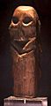
Oak figurine found in Willemstad (4500 BC)
-
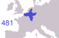
Frankish expansion (481 to 870 AD)
-
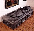
A medieval tomb of the Brabantian knight Arnold van der Sluijs
-
Map of the Habsburg dominions. From 1556 the dynasty's lands in the Low Countries were retained by the Spanish Habsburgs.
-
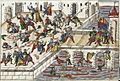
The Spanish Fury at Maastricht, 1579
-
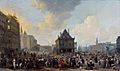
Dutch East India Company factory in Hugli-Chuchura, Mughal Bengal by Hendrik van Schuylenburgh, 1665
-
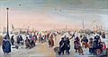
Winter landscape with skaters near the city of Kampen by Hendrick Avercamp (1620s)
-
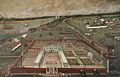
Amsterdam's Dam Square in 1656
-
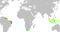
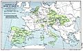
Map of the Dutch colonial empire. Light green: territories administered by or originating from territories administered by the Dutch East India Company; dark green: the Dutch West India Company. In yellow are the territories occupied later, during the 19th century.
-
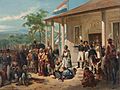
The submission of Diponegoro to General De Kock at the end of the Java War in 1830. Painting by Nicolaas Pieneman
-
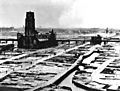
Rotterdam after German air raids in 1940
-
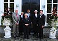
Former Prime Ministers Wim Kok, Dries van Agt, Piet de Jong, Ruud Lubbers and Jan Peter Balkenende with Prime Minister Mark Rutte, in 2011
-
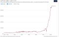
Historical GDP per capita development (Our World in Data)
-
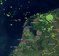
Natural gas concessions in the Netherlands. Today the Netherlands accounts for more than 25% of all natural gas reserves in the EU.
-
The Groningen gas field whose discovery in 1959 transformed the Dutch economy, generating €159 billion in revenue since the mid-1970s
-
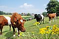
Cows near the city of Arnhem
-
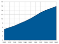
Population of the Netherlands from 1900 to 2000
-
In Rotterdam almost half the population has an immigrant background.
-
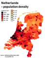
Population density in the Netherlands by municipality. The largest urban area, the Randstad is clearly visible along the west coast.
-
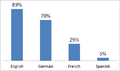
Knowledge of foreign languages in the Netherlands, among population 15 and older, in 2006
-
An international primary school in The Hague
-
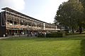
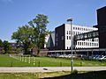
View on the Utrecht Science Park of Utrecht University. The building in the centre is the library.
-
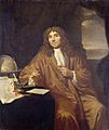
Portrait of Antonie van Leeuwenhoek (1632–1723), known as "the father of microbiology"
-
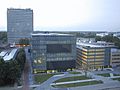
A public hospital in Amersfoort
-
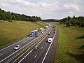
A1 motorway, in Gelderland
-
Some symbols and icons of Dutch art
-
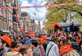
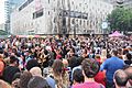
Dutch people in orange celebrating King's Day in Amsterdam, 2017
-
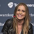
Pop singer Anouk in 2013
-
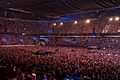
Johan Cruyff Arena, the largest Dutch concert venue
-
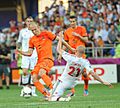
Dutch star football players Arjen Robben and Robin van Persie during a game with the Netherlands against Denmark at Euro 2012


,_Johann_Jakob_Wick_(cropped).jpg)


_-_panoramio.jpg)


._Natuurkundige_te_Delft_Rijksmuseum_SK-A-957.jpeg)


.jpg)
.jpg)
.jpg)
See also
 In Spanish: Países Bajos para niños
