
Utah facts for kids
Quick facts for kids
Utah
|
|||
|---|---|---|---|
|
|||
| Nicknames:
"Beehive State" (official), "The Mormon State", "Deseret"
|
|||
| Motto(s):
Industry
|
|||
| Anthem: "Utah...This Is the Place" "Utah, We Love Thee" | |||

Location of Utah within the United States
|
|||
| Country | United States | ||
| Before statehood | Utah Territory | ||
| Admitted to the Union | January 4, 1896 (45th) | ||
| Capital (and largest city) |
Salt Lake City | ||
| Largest county or equivalent | Salt Lake | ||
| Largest metro and urban areas | Salt Lake City | ||
| Legislature | State Legislature | ||
| • Upper house | State Senate | ||
| • Lower house | House of Representatives | ||
| Judiciary | Utah Supreme Court | ||
| U.S. senators | Mike Lee (R) John Curtis (R) |
||
| U.S. House delegation | 1: Blake Moore (R) 2: Celeste Maloy (R) 3: Mike Kennedy (R) 4: Burgess Owens (R) (list) |
||
| Area | |||
| • Total | 84,899 sq mi (219,887 km2) | ||
| • Land | 82,144 sq mi (212,761 km2) | ||
| • Water | 2,755 sq mi (7,136 km2) 3.25% | ||
| Area rank | 13th | ||
| Dimensions | |||
| • Length | 350 mi (560 km) | ||
| • Width | 270 mi (435 km) | ||
| Elevation | 6,100 ft (1,860 m) | ||
| Highest elevation | 13,534 ft (4,120.3 m) | ||
| Lowest elevation
(Beaver Dam Wash at Arizona border)
|
2,180 ft (664.4 m) | ||
| Population
(2025)
|
|||
| • Total | |||
| • Rank | 30th | ||
| • Density | 36.53/sq mi (14.12/km2) | ||
| • Density rank | 41st | ||
| • Median household income | $93,400 (2023) | ||
| • Income rank | 8th | ||
| Demonym(s) | Utahn | ||
| Language | |||
| • Official language | English | ||
| Time zone | UTC−07:00 (Mountain) | ||
| • Summer (DST) | UTC−06:00 (MDT) | ||
| USPS abbreviation |
UT
|
||
| ISO 3166 code | US-UT | ||
| Traditional abbreviation | Ut. | ||
| Latitude | 37° N to 42° N | ||
| Longitude | 109°3′ W to 114°3′ W | ||


| Emblem | Beehive |
|---|---|
| Dance | Square dance |
| Bird | California gull |
| Fish | Bonneville cutthroat trout |
| Flower | Sego lily |
| Tree | Quaking aspen |
| Insect | Western honey bee |
Utah (pronounced YOO-tah or YOO-taw) is a state in the western part of the United States. It is one of the Mountain States, sharing a border with Arizona, Colorado, and New Mexico at the Four Corners region. Utah also borders Wyoming to the northeast, Idaho to the north, and Nevada to the west.
Utah is the 13th largest state by land area. With a population of just over three million people, it is the 30th most populated state. Most people live in two main areas: the Wasatch Front in north-central Utah, which includes the capital city of Salt Lake City, and Washington County in the southwest. The western half of Utah is mostly part of the Great Basin.
For thousands of years, different Native American groups lived in Utah. These included the Ancestral Puebloans, the Navajo, and the Ute. The first Europeans, the Spanish, arrived in the mid-1500s. Because of its tough geography and climate, the area was not a main part of New Spain or later, Mexico.
Many early European settlers in Utah were Mormons from the United States. They were looking for a place where they could practice their religion freely. They arrived by following the Mormon Trail. In 1848, after the Mexican–American War, the U.S. took over the region. It became part of the Utah Territory, which also included parts of what are now Colorado and Nevada. Utah became the 45th state in 1896, after agreeing to outlaw polygamy.
People from Utah are called Utahns. More than half of all Utahns are Mormons. Most of them are members of the Church of Jesus Christ of Latter-day Saints (LDS Church). Their world headquarters are in Salt Lake City. Utah is the only state where most people belong to one church. The LDS Church has a big impact on Utah's culture, politics, and daily life. However, since the 1990s, the state has become more diverse in its religions and also has more people who are not religious.
Utah has a strong and varied economy. Important parts of its economy include transportation, education, technology, government services, mining, and tourism. Utah has been one of the fastest-growing states since 2000. The 2020 U.S. census showed it had the fastest population growth in the nation since 2010. St. George was the fastest-growing metropolitan area in the U.S. from 2000 to 2005. Utah is ranked among the best states for things like healthcare, government, education, and roads. It has the 12th-highest average income and the least income inequality of any U.S. state. However, droughts in Utah are happening more often and are more severe due to climate change. This puts a strain on Utah's water supply and affects its economy.
Contents
What Does the Name "Utah" Mean?
The name "Utah" comes from the Ute tribe. In their language, it means "people of the mountains." Some sources say "Utah" comes from the Apache word "Yudah," meaning "Tall." The Spanish later called it "Yuta," and English speakers changed it to "Utah."
Utah's Past: A Look at Its History
Early People in Utah
Thousands of years ago, before Europeans arrived, the Ancestral Puebloans and the Fremont people lived in what is now Utah. These Native American groups were part of the Ute-Aztec family. They built homes, with the Ancestral Pueblo people making theirs in mountains. The Fremont people built houses from straw. They disappeared from the region around the 1400s.

Around the 1700s, the Navajo settled in the area. By the mid-1700s, other Uto-Aztecan tribes like the Goshute, Paiute, Shoshone, and Ute people also moved into the region. These five groups were living there when the first European explorers arrived.
Spanish Explorers and Fur Traders
Spanish explorers, led by Francisco Vázquez de Coronado, explored southern Utah in 1540. They were looking for the legendary Cíbola. In 1776, a group led by two Catholic priests, known as the Domínguez–Escalante expedition, left Santa Fe. They hoped to find a route to California. They traveled as far north as Utah Lake and met the native people. The Spanish explored more but did not want to settle the desert area. In 1821, when Mexico became independent from Spain, the region became part of its territory called Alta California.
European trappers and fur traders explored parts of Utah in the early 1800s. They came from Canada and the United States. The city of Provo, Utah is named after Étienne Provost, who visited in 1825. Ogden, Utah is named after Peter Skene Ogden, a Canadian fur trader.
In late 1824, Jim Bridger was the first English-speaking person known to see the Great Salt Lake. He thought it was the Pacific Ocean because its water was so salty. After the lake was discovered, many American and Canadian traders set up trading posts. In the 1830s, thousands of migrants traveling west stopped in the Great Salt Lake region.
Mormon Settlers Arrive in Utah

After the death of Joseph Smith in 1844, Brigham Young became the leader of the Church of Jesus Christ of Latter-day Saints. To avoid conflicts with their neighbors, Young agreed in October 1845 that the Mormons would leave Illinois.
Brigham Young and the first group of Mormon pioneers arrived in the Salt Lake Valley on July 24, 1847. Over the next 22 years, more than 70,000 pioneers traveled across the plains to settle in Utah. For the first few years, they worked hard to survive in the dry desert land. The Mormons saw this arid land as a good place to practice their religion without being bothered.
The Mormon settlements helped establish other communities in the West. They built irrigation systems to support large populations along Utah's Wasatch Front. This included Salt Lake City, Bountiful, Weber Valley, Provo, and Utah Valley. Throughout the rest of the 1800s, Mormon pioneers started hundreds of other settlements. These were in Utah, Idaho, Nevada, Arizona, Wyoming, California, Canada, and Mexico.
Utah was Mexican territory when the first pioneers arrived in 1847. The United States took control of New Mexico and California during the Mexican–American War in late 1846. The entire Southwest became U.S. territory after the Treaty of Guadalupe Hidalgo was signed on February 2, 1848. The settlers in Utah wanted to become a state. They proposed a large area called the State of Deseret.
Utah as a U.S. Territory (1850–1896)


The Utah Territory was created in 1850 as part of the Compromise of 1850. It was smaller than the proposed State of Deseret. But it still included all of present-day Nevada and Utah, plus parts of Wyoming and Colorado. Fillmore was named the capital. The territory was named Utah after the Ute Native American tribe. Salt Lake City became the capital in 1856.
In September 1857, about 120 American settlers were killed by the Utah Territorial Militia and some Paiute Native Americans. This event is known as the Mountain Meadows Massacre.
Salt Lake City was the last connection for the First transcontinental telegraph. It was finished in October 1861. Brigham Young was among the first to send a message.
During the American Civil War, federal troops left Utah Territory in 1861. This helped the local economy because the army sold their supplies cheaply. The territory was then left to the LDS community. In 1862, Patrick Edward Connor arrived with California volunteers. He set up Fort Douglas near Salt Lake City. Connor encouraged his soldiers to find minerals to bring more non-Mormons to the territory. Minerals were found in Tooele County, and miners began to arrive.
From 1865 to 1872, Utah had its deadliest conflict, the Black Hawk War. Chief Antonga Black Hawk died in 1870, but fighting continued until more federal troops were sent. This war was unusual because it involved three groups: the Timpanogos Utes led by Antonga Black Hawk, and federal and LDS authorities.
On May 10, 1869, the First Transcontinental Railroad was completed at Promontory Summit, north of the Great Salt Lake. The railroad brought more people to Utah. Many businesspeople became rich there.
Utah officially became a state on January 4, 1896.
Utah in the 20th and 21st Centuries


In the early 1900s, Utah became famous for its natural beauty. National parks like Bryce Canyon National Park and Zion National Park were created. Southern Utah became a popular place to film western movies. Famous landmarks like Delicate Arch and Monument Valley appeared in films.
Utah's skiing became world-renowned after Alta Ski Area opened in 1939. The dry, powdery snow in the Wasatch Range is considered some of the best. Salt Lake City hosted the 2002 Winter Olympic Games. This event greatly boosted the state's economy and tourism. The state also hosted the games in 2026. It will host them again in 2034.
In 1957, Utah started its State Parks Commission. Today, Utah State Parks manages 43 parks. These parks cover a huge amount of land and water. They are found all over Utah, from north to south.
Utah has grown very quickly since the late 1900s. Many areas, especially around the Wasatch Front, have seen rapid growth. Managing transportation and city growth are important issues. This is because development uses up farmland and natural areas.
The state also hosted the games in 2026. It will host them again in 2034.
Utah's Amazing Geography


Utah is known for its diverse natural features. It has everything from dry deserts with sand dunes to thick pine forests in mountain valleys. It is a rugged state with varied geography. Utah is where three different geological regions meet: the Rocky Mountains, the Great Basin, and the Colorado Plateau.
Utah is one of the Four Corners states. It borders Idaho to the north, Wyoming to the north and east, Colorado to the east, and Arizona to the south. It touches New Mexico at one point in the southeast and Nevada to the west. Utah covers an area of about 84,899 square miles (219,887 square kilometers). It is one of only three U.S. states (along with Colorado and Wyoming) that have only straight lines of latitude and longitude as borders.
One of Utah's most notable features is its varied terrain. The Wasatch Range runs down the middle of the northern third of the state. These mountains reach heights of almost 12,000 feet (3,658 meters) above sea level. Utah has world-famous ski resorts. They are popular because of the light, fluffy snow and winter storms that often bring 1 to 3 feet of snow overnight. In the northeastern part of the state, the Uinta Mountains run east to west. They rise to over 13,000 feet (3,962 meters). The highest point in Utah, Kings Peak, is in the Uinta Mountains. It is 13,528 feet (4,120 meters) high.
At the western base of the Wasatch Range is the Wasatch Front. This area has many valleys and basins where most of the state's population lives. It stretches from Brigham City in the north to Nephi in the south. About 75 percent of Utah's people live in this area, and the population is growing fast.
Western Utah is mostly dry desert with a basin and range landscape. Small mountain ranges and rugged areas dot the land. The Bonneville Salt Flats are an exception. They are very flat because they were once the bed of an ancient lake called Lake Bonneville. The Great Salt Lake, Utah Lake, Sevier Lake, and Rush Lake are all what's left of this old freshwater lake. West of the Great Salt Lake, stretching to the Nevada border, is the dry Great Salt Lake Desert. One green area is Snake Valley. It is lush because of large springs and wetlands fed by snowmelt from nearby mountains. Great Basin National Park is just over the Nevada state line. One of western Utah's most impressive but less visited spots is Notch Peak. It has the tallest limestone cliff in North America and is west of Delta.
Much of the beautiful southern and southeastern landscape is made of sandstone. This is especially true in the Colorado Plateau region. The Colorado River and its smaller rivers flow through the sandstone. They create some of the world's most stunning and wild terrain. Wind and rain have also shaped the soft sandstone over millions of years. Canyons, gullies, arches, pinnacles, buttes, bluffs, and mesas are common sights in south-central and southeast Utah.
This unique landscape is the main feature of many protected parks. These include Arches, Bryce Canyon, Canyonlands, Capitol Reef, and Zion national parks. Also, there are national monuments like Cedar Breaks, Grand Staircase-Escalante, Hovenweep, and Natural Bridges. Other popular spots are Glen Canyon National Recreation Area (home to Lake Powell), Dead Horse Point and Goblin Valley state parks, and Monument Valley. The Navajo Nation also extends into southeastern Utah. This area also has remote but tall mountain ranges like the La Sal, Abajo, and Henry mountains.
Eastern Utah (the northern quarter) is a high-elevation area. It is mostly covered by plateaus and basins, like the Tavaputs Plateau and San Rafael Swell. These areas are mostly hard to reach. The Uinta Basin is where most of eastern Utah's population lives. The economy here relies on mining, oil shale, oil, and natural gas drilling. Ranching and outdoor activities are also important. Much of eastern Utah is part of the Uintah and Ouray Indian Reservation. A popular place to visit in northeastern Utah is Dinosaur National Monument near Vernal.
Southwestern Utah is the lowest and hottest part of the state. It is called Utah's Dixie because early settlers could grow cotton there. Beaver Dam Wash in far southwestern Utah is the lowest point in the state, at 2,000 feet (610 meters). The northernmost part of the Mojave Desert is also in this area. Dixie is quickly becoming a popular place for recreation and retirement, and its population is growing fast. While the Wasatch Mountains end near Nephi, a complex series of mountain ranges extends south through Utah. Just north of Dixie and east of Cedar City is the state's highest ski resort, Brian Head.
Like most western and southwestern U.S. states, the federal government owns much of the land in Utah. Over 70 percent of the land is public land managed by the BLM, Utah State Trustland, U.S. National Forest, U.S. National Park, U.S. National Monument, National Recreation Area, or U.S. Wilderness Area. Utah is the only state where every county has some national forest land.
Utah's Climate and Weather

Utah has a dry, semi-arid to desert climate. However, its many mountains have a variety of climates. The highest points in the Uinta Mountains are above the timberline (where trees can no longer grow). The dry weather is because Utah is in the rain shadow of the Sierra Nevada mountains in California. The eastern half of the state is in the rain shadow of the Wasatch Mountains. Most of Utah's rain and snow comes from Pacific Ocean storms from October to May. In summer, especially in southern and eastern Utah, the state gets moisture from the monsoon winds coming from the Gulf of California.

Utah's temperatures can be extreme. Winters are cold due to the state's elevation. Summers are very hot across the state, except in mountain areas and high mountain valleys. Utah is usually protected from very cold air by mountains to its north and east. However, sometimes major Arctic cold fronts can reach the state. Average high temperatures in January range from about 30°F (-1°C) in some northern valleys to almost 55°F (13°C) in St. George.
Utah, like most of the western United States, does not have many thunderstorms. On average, there are fewer than 40 days of thunderstorms each year. But when they do happen, they can be very strong for a short time. They are most likely during the monsoon season, from mid-July to mid-September, especially in southern and eastern Utah. Dry lightning often starts wildfires in summer. Intense thunderstorms can cause flash flooding, especially in the rugged southern Utah terrain. While spring is the wettest season in northern Utah, late summer is the wettest for much of the south and east. Tornadoes are rare in Utah. On average, two hit the state each year, and they are usually not very strong.
How Utah's Government Works

Utah's government has three parts: executive, legislative, and judicial. The governor is the state's chief executive. They are elected for a four-year term. A lieutenant governor is elected at the same time as the governor. Besides the governor and lieutenant governor, Utah also elects a state auditor, a state treasurer, and an attorney general.
The Utah State Legislature has two parts: a Senate and a House of Representatives. State senators serve four-year terms, and representatives serve two-year terms. The Utah Legislature meets every January for a 45-day session.
The Utah Supreme Court is the highest court in Utah. It has five justices. They are chosen by the governor and then voted on by the public to stay in their jobs. The Utah Court of Appeals handles cases from lower courts. The trial courts are the district courts and justice courts. All judges, like those on the Utah Supreme Court, are subject to a public vote to keep their positions after being appointed.
People and Population in Utah

In 2020, Utah had a population of 3,271,616 people. The U.S. Census Bureau estimated that the population was 3,205,958 on July 1, 2019. This was a 16% increase since the 2010 U.S. census. Most of Utah's population lives in cities and towns along the Wasatch Front. This is a metropolitan area that runs north-south with the Wasatch Mountains to the east. Population growth outside the Wasatch Front is also increasing. The St. George metropolitan area is currently the second fastest-growing in the country.
Utah has five metropolitan areas: Logan, Ogden-Clearfield, Salt Lake City, Provo-Orem, and St. George. It also has six smaller micropolitan areas.
Who Lives in Utah?
The largest ancestry groups in Utah are:
- 26.0% English
- 11.9% German
- 11.8% Scandinavian (Danish, Swedish, Norwegian)
- 9.0% Mexican
- 6.6% American
- 6.2% Irish
- 4.6% Scottish
In 2011, one-third of Utah's workers were bilingual. This is partly due to a program that teaches second languages starting in elementary school. It is also related to the LDS Church's missionary goals for young people.
In 2011, 28.6% of Utah's population under one year old were ethnic minorities. This means they had at least one parent who was not non-Hispanic white.
Religion in Utah


Mormons are the largest religious group in Utah. However, the percentage of Mormons in the total population has been going down. In 2017, 62.8% of Utahns were members of the LDS Church. This dropped to 60.7% in 2019. Members of the LDS Church now make up between 34%–41% of the population within Salt Lake City. However, many other major cities like Provo, Logan, Tooele, and St. George, along with many suburban and rural areas, are mostly LDS. The LDS Church has the most congregations, with 4,815 wards.
The LDS Church officially stays neutral about political parties. But the church's teachings have a strong influence on politics in the region. Another effect of their beliefs is Utah's high birth rate. It is 25 percent higher than the national average, the highest for any U.S. state. Mormons in Utah tend to have conservative views on most political issues. Most Utahns who vote are unaffiliated voters (60%) who vote mostly Republican. For example, Mitt Romney received 72.8% of Utah votes in 2012.
According to a Gallup poll in 2015, Utah had the third-highest number of people who said they were "Very Religious," at 55%. It was close to the national average for "Nonreligious" people (31%). It had the smallest percentage of people who said they were "Moderately Religious" (15%). Utah also had the highest average weekly church attendance of any state, at 51%.
Languages Spoken in Utah
The official language in Utah is English. The English spoken in Utah is a mix of Northern and Midland American dialects. These were brought west by LDS Church members. Their original New York dialect later picked up features from northeast Ohio and central Illinois. Some people in the central valley, though less often in Salt Lake City now, pronounce the vowels /ɑ/ and /ɔ/ the same before an /ɹ/. This means words like cord and card sound alike.
In 2000, 87.5% of all Utah residents aged five or older spoke only English at home. This was a decrease from 92.2% in 1990.
- Top Non-English Languages Spoken in Utah (2010)
- Spanish: 7.4%
- German: 0.6%
- Navajo: 0.5%
- French: 0.4%
- Pacific Island languages (like Chamorro, Hawaiian, Ilocano, Tagalog, and Samoan): 0.4%
- Chinese: 0.4%
- Portuguese: 0.3%
- Vietnamese: 0.3%
- Japanese: 0.2%
- Arapaho: 0.1%
Age and Gender in Utah
Utah has the highest birth rate and the youngest population of any U.S. state. In 2010, the state's population was 50.2% male and 49.8% female. The average life expectancy is 79.3 years.
Utah's Economy and Industries


In 2025, Utah's total economic output was $315.9 billion. The average personal income per person was $69,991.
Utah's main industries include mining, cattle ranching, and salt production. Government services are also a big part of the economy.
Utah has been ranked as a top state for economic growth. In 2014, Forbes magazine called Utah the "Best State For Business." A 2010 Newsweek article called the Salt Lake City area "the new economic Zion." It noted how the area attracted high-tech companies. As of May 2025, the state's unemployment rate was 3.2%.
In eastern Utah, making petroleum is a major industry. Near Salt Lake City, several companies refine petroleum. In central Utah, coal production is a big part of mining. Historical mining towns include Mercur and Park City.
During the early Cold War, uranium was mined in eastern Utah. Minerals mined include copper, gold, silver, and lead. Fossil fuels like coal, petroleum, and natural gas are also important.
Utah produces more coal and electricity than it uses. The state has great potential for solar power and wind power.
Utah Associated Municipal Power Systems (UAMPS) is a state organization. It provides wholesale electricity and energy services to communities.
Taxes in Utah
Utah collects income tax. Since 2008, the tax has been a flat five percent for everyone. The state sales tax is 6.45 percent. Cities and counties add their own local sales taxes, which vary. Property taxes are collected by local governments. Utah does not charge taxes on intangible property (like patents) and does not have an inheritance tax.
Tourism in Utah
Tourism is a very important industry in Utah. With five national parks (Arches, Bryce Canyon, Canyonlands, Capitol Reef, and Zion), Utah has the third most national parks of any state. Only Alaska and California have more. Utah also has eight national monuments, two national recreation areas, seven national forests, and many state parks.
The Moab area in southeastern Utah is famous for its challenging mountain biking trails, like Slickrock Trail. Moab also hosts the well-known Moab Jeep Safari twice a year.
Tourism in Utah has grown since the 2002 Winter Olympics. Park City is home to the United States Ski Team. Utah's ski resorts are mostly in northern Utah, near Salt Lake City, Park City, Ogden, and Provo. From 2007 to 2011, Deer Valley in Park City was ranked the top ski resort in North America by Ski Magazine.
Utah has many great ski resorts. A 2009 Ski Magazine survey found that six of the top ten resorts for "accessibility" and six of the top ten with the best snow were in Utah. In Southern Utah, Brian Head Ski Resort is in the mountains near Cedar City. Former Olympic venues like Utah Olympic Park and Utah Olympic Oval are still used for training and competitions. The public can also try activities like ski jumping, bobsleigh, and speed skating.
Utah offers many cultural attractions. These include Temple Square, the Sundance Film Festival, the Red Rock Film Festival, the DOCUTAH Film Festival, the Utah Data Center, and the Utah Shakespeare Festival. Forbes magazine ranks Temple Square as the 16th most visited tourist attraction in the United States, with over five million visitors each year.
Other popular places to visit include Monument Valley, the Great Salt Lake, the Bonneville Salt Flats, and Lake Powell.

How Utah Promotes Itself
Utah gets a lot of money from tourists visiting its parks and ski resorts. So, it's important to "brand" Utah and make a good impression around the world. This has led to several state slogans. The most famous is "The Greatest Snow on Earth." Utah has used this slogan officially since 1975, and it is on almost half of the state's license plates. In 2001, Governor Mike Leavitt approved a new slogan, "Utah! Where Ideas Connect." This lasted until March 10, 2006, when "Life Elevated" became the new state slogan.
Getting Around Utah: Transportation


I-15 and I-80 are the main interstate highways in Utah. They meet and briefly merge near downtown Salt Lake City. I-15 runs north-to-south, entering from Arizona near St. George and going into Idaho near Portage. It runs alongside the Wasatch Front. I-80 goes east-to-west across northern Utah. It enters from Nevada at Wendover, crosses the Wasatch Mountains east of Salt Lake City, and goes into Wyoming near Evanston. I-84 West enters from Idaho near Snowville. It merges with I-15 from Tremonton to Ogden, then heads southeast through the Wasatch Mountains before ending at I-80 near Echo Junction.
I-70 splits from I-15 at Cove Fort in central Utah. It heads east through mountains and rugged desert. This highway provides easy access to many national parks and monuments in southern Utah. It is known for its beautiful scenery. The 103-mile stretch from Salina to Green River is the longest part of an interstate without services in the country. When it was finished in 1970, it was the longest stretch of completely new highway built in the U.S. since the Alaska Highway in 1943.
TRAX is a light rail system in the Salt Lake Valley with three lines. The Blue Line runs from Draper to Downtown Salt Lake City. The Red Line goes from South Jordan to the University of Utah. The Green Line starts in West Valley City, goes through downtown Salt Lake City, and ends at Salt Lake City International Airport.
The Utah Transit Authority (UTA), which runs TRAX, also operates a bus system. It covers the Wasatch Front, extends west to Grantsville, and east to Park City. UTA also provides winter bus service to ski resorts near Salt Lake City, Ogden, and Provo. Other bus companies also serve ski resorts in winter. Local bus companies serve cities like Cedar City, Logan, Park City, and St. George. A commuter rail line called FrontRunner, also run by UTA, travels between Ogden and Provo through Salt Lake City. Amtrak's California Zephyr train runs east-west through Utah daily. It stops in Green River, Helper, Provo, and Salt Lake City.
Salt Lake City International Airport is Utah's only international airport. It is a hub for Delta Air Lines. The airport is often ranked first for on-time departures and has few cancellations among U.S. airports. It has direct flights to over a hundred places in the United States, Canada, and Mexico, as well as to Amsterdam, London, and Paris. Other airports like Canyonlands Field (near Moab), Cedar City Regional Airport, Ogden-Hinckley Airport, Provo Municipal Airport, St. George Regional Airport, and Vernal Regional Airport offer limited commercial flights. A new regional airport in St. George opened on January 12, 2011. SkyWest Airlines is based in St. George and has a hub at Salt Lake City.
Major Cities and Towns in Utah


.jpg)


Most of Utah's population lives in two areas. The Wasatch Front in north-central Utah has over 2 million people. Washington County, in southwestern Utah, known as "Dixie", has over 150,000 residents in its metropolitan area.
- Largest Cities in Utah (2010 Population)
- 1. Salt Lake City: 186,440 people
- 2. West Valley City: 129,480 people
- 3. Provo: 112,488 people
- 4. West Jordan: 103,712 people
- 5. Orem: 88,328 people
- 6. Sandy: 87,461 people
- 7. Ogden: 82,825 people
- 8. St. George: 72,897 people
- 9. Layton: 67,311 people
- 10. Taylorsville: 58,652 people
- Largest Metropolitan Areas in Utah (2010 Population)
- 1. Salt Lake City*: 1,124,197 people (includes Salt Lake, Tooele, Summit counties)
- 2. Ogden-Clearfield*: 547,184 people (includes Weber, Davis, Morgan counties)
- 3. Provo-Orem: 526,810 people (includes Utah County)
- 4. St. George: 138,115 people (includes Washington County)
- 5. Logan: 125,442 people (includes Cache County, Utah, and Franklin County, Idaho)
- Until 2003, Salt Lake City and Ogden-Clearfield metropolitan areas were considered one large area.
- Largest Micropolitan Areas in Utah (2010 Population)
- 1. Brigham City: 49,015 people
- 2. Cedar City: 44,540 people
- 3. Vernal: 29,885 people
- 4. Heber: 21,066 people
- 5. Price: 19,549 people
- 6. Richfield: 18,382 people
Images for kids
-
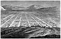
A sketch of Salt Lake City in 1860
-
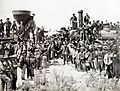
The Golden Spike where the First Transcontinental Railroad was completed in the U.S. on May 10, 1869, in Promontory, Utah.
-
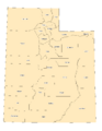
Utah county boundaries.
-
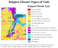
Köppen climate types of Utah, using 1991-2020 climate normals.
-
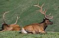
The Rocky Mountain elk is the Utah state mammal.
-
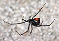
Western black widow spider.
-
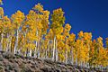
Pando, considered one of the heaviest and oldest organisms on Earth.
-

The Huntsman Cancer Institute on the campus of the University of Utah in Salt Lake City.
-

The Utah Jazz playing against the Houston Rockets.
-
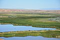
Pariette Wetlands.
-
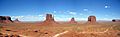
Monument Valley in southeastern Utah. This area was used to film many Hollywood Westerns.
-
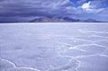
The otherworldly look of the Bonneville Salt Flats has been used in many movies and commercials.


.jpg)


.jpg)


See also
 In Spanish: Utah para niños
