
List of National Historic Landmarks in California facts for kids
California is home to many amazing places that are recognized as National Historic Landmarks. These special places are chosen by the National Park Service because they are super important to the history of the United States. They show us all sorts of things about California's past, like its first people, the time when Spain and Mexico ruled, exciting sea adventures, and even space exploration!
Alcatraz Island in San Francisco Bay, a National Historic Landmark since 1986
There are 148 of these landmarks spread across 36 of California's 58 counties. Let's explore some of them!

Current National Historic Landmarks
One landmark, Yuma Crossing and Associated Sites, is shared with Arizona. Another, Lower Klamath National Wildlife Refuge, is shared with Oregon.
| Landmark name | Image | Date designated | Location | County | Description | |
|---|---|---|---|---|---|---|
| 1 | The Abbey, Joaquin Miller House |
.JPG) |
(#66000204) |
Oakland 37°48′45″N 122°11′08″W / 37.8125°N 122.1855°W |
Alameda | This was the home of Joaquin Miller, a famous writer known as the "Poet of the Sierras," from 1886 until he passed away in 1913. |
| 2 | The Ahwahnee |
.jpg) |
(#77000149) |
Yosemite National Park 37°44′45″N 119°34′27″W / 37.74575°N 119.5741°W |
Mariposa | This hotel in Yosemite National Park was built by the National Park Service. It's a great example of "National Park Service Rustic" style, which uses natural materials to blend with the environment. |
| 3 | Alcatraz Island |
 |
(#76000209) |
San Francisco 37°49′35″N 122°25′21″W / 37.8264°N 122.4225°W |
San Francisco | This island was once a famous high-security prison. It's now part of the Golden Gate National Recreation Area and is a popular spot for tourist ferries. |
| 4 | Alma (scow schooner) |
_1.JPG) |
(#75000179) |
San Francisco 37°48′28″N 122°25′15″W / 37.8077°N 122.4208°W |
San Francisco | The Alma is a flat-bottomed scow schooner built in 1891. It used to sail in San Francisco Bay and the Sacramento-San Joaquin River Delta. Today, it's part of the San Francisco Maritime National Historical Park. |
| 5 | Angelus Temple |
 |
(#92001875) |
Los Angeles 34°04′35″N 118°15′41″W / 34.0763°N 118.2613°W |
Los Angeles | This church was built by Aimee Semple McPherson, a very popular religious speaker in the 1920s and 1930s. |
| 6 | Juan de Anza House |
 |
(#70000140) |
San Juan Bautista 36°50′37″N 121°32′07″W / 36.8436°N 121.5353°W |
San Benito | This one-story adobe house shows what homes looked like during the Mexican era in California. It was later changed to fit American styles. |
| 7 | Aquatic Park Historic District |
 |
(#84001183) |
San Francisco 37°48′23″N 122°25′25″W / 37.8064°N 122.4236°W |
San Francisco | This district includes a beach, pier, and a public bathhouse. It was built in 1936 by the Works Progress Administration (WPA) and has a cool Streamline Moderne design. |
| 8 | Asilomar Conference Grounds |
 |
(#87000823) |
Pacific Grove 36°37′11″N 121°55′53″W / 36.6197°N 121.9314°W |
Monterey | This conference center was built in 1913 for the YWCA by architect Julia Morgan. It's a great example of Arts and Crafts architecture. |
| 9 | Balboa Park |
 |
(#77000331) |
San Diego 32°43′53″N 117°08′43″W / 32.7314°N 117.1453°W |
San Diego | Balboa Park is a huge 1,200-acre (4.9 km²) park in San Diego. It was set aside in 1855, making it one of the oldest public parks in the United States. It has gardens, museums, theaters, and even the San Diego Zoo. |
| 10 | Balclutha (square-rigger) |
_2_edit1.jpg) |
(#76000178) |
San Francisco 37°48′36″N 122°25′21″W / 37.8099°N 122.4225°W |
San Francisco | The Balclutha is the only square rigged ship left in the San Francisco Bay area. Built in 1886, it sailed on many trade routes. Now, it's part of the San Francisco Maritime National Historical Park. |
| 11 | Baldwin Hills Village |
 |
(#93000269) |
Baldwin Hills 34°01′11″N 118°21′39″W / 34.0197°N 118.3608°W |
Los Angeles | Now called Village Green, this complex of 627 homes was one of the first planned communities built between 1935 and 1942. |
| 12 | Hubert H. Bancroft Ranch House |
.jpg) |
(#66000227) |
Spring Valley 32°44′44″N 117°00′07″W / 32.745569°N 117.001974°W |
San Diego | This adobe home belonged to Hubert Howe Bancroft, a historian who published many books about the Pacific Coast and Native American culture. |
| 13 | Bank of Italy Building |
 |
(#78000754) |
San Francisco 37°47′40″N 122°24′11″W / 37.7944°N 122.4030°W |
San Francisco | This building became the main office of the Bank of Italy in 1908. The Bank of Italy later became the Bank of America. |
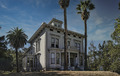
| 14 | Aline Barnsdall Complex (Hollyhock House) |
.jpg) |
(#71000143) |
Los Angeles 34°06′00″N 118°17′41″W / 34.0999°N 118.2946°W |
Los Angeles | Hollyhock House was designed by famous architect Frank Lloyd Wright and built between 1919 and 1921 for Aline Barnsdall. It's now the main building of the Barnsdall Art Park. |
| 15 | Berkeley (ferry) |
 |
(#90002220) |
San Diego 32°43′01″N 117°10′21″W / 32.7169°N 117.1726°W |
San Diego | The Berkeley was the first ferry on the West Coast to be powered by a propeller. Today, it's the main "building" of the Maritime Museum of San Diego. |
| 16 | Big Four House |
 |
(#76000541) |
Sacramento 38°34′58″N 121°30′12″W / 38.5827°N 121.503333°W |
Sacramento | Built in 1852, this house is where Collis Huntington, Mark Hopkins, Leland Stanford, and Charles Crocker started the Central Pacific Railroad. |
| 17 | Bodie Historic District |
 |
(#66000213) |
Bodie 38°12′44″N 119°00′44″W / 38.21222°N 119.01222°W |
Mono | Bodie was a busy Gold Rush town that started in 1859. It's now a State Park, kept in a state of "arrested decay," meaning it's preserved as it was, not fully restored. |
| 18 | Borax Lake Site |
 |
(#91001424) |
Clearlake |
Lake | This is an important archaeological site where ancient Paleo-Indians lived. It showed that the Clovis culture lived in more places than previously thought. |
| 19 | Bradbury Building |
 |
(#71000144) |
Los Angeles 34°03′03″N 118°14′53″W / 34.050744°N 118.248170°W |
Los Angeles | This building, built in 1893, is famous for its beautiful inside design and old-fashioned cage elevators. It has been featured in many movies, like Blade Runner. |
| 20 | Luther Burbank House and Garden |
 |
(#66000241) |
Santa Rosa 38°26′10″N 122°42′44″W / 38.436141°N 122.712208°W |
Sonoma | This city park includes the former home, greenhouse, gardens, and grave of Luther Burbank, a famous American plant scientist. |
| 21 | C.A. Thayer (schooner) |
 |
(#66000229) |
San Francisco 37°48′28″N 122°25′16″W / 37.8079063201°N 122.421081619°W |
San Francisco | The C.A. Thayer is a schooner built in 1895. It used to carry lumber to San Francisco from other states. Now, it's preserved at the San Francisco Maritime National Historical Park. |
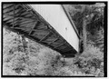
| 22 | California Powder Works Bridge |
 |
(#15000279) |
Santa Cruz 37°00′38″N 122°02′38″W / 37.0106°N 122.044°W |
Santa Cruz | This covered bridge from 1872 is one of the best examples of the Smith truss design in the country. |
| 23 | Carmel Mission |
 |
(#66000214) |
Carmel 36°32′28″N 121°55′07″W / 36.5410005723°N 121.918551601°W |
Monterey | This was the second California Mission Church. It was the main office for Father Fermin Francisco de Lasuen. It has been restored and is still a church today. |
| 24 | Carrizo Plain Archeological District |
 |
(#01000509) |
San Luis Obispo 35°11′29″N 119°43′34″W / 35.191389°N 119.7261°W |
San Luis Obispo | This large grassland area is very important for history and the environment. It's the biggest native grassland left in California. |
| 25 | Jose Castro House |
.jpg) |
(#70000141) |
San Juan Bautista 36°50′34″N 121°32′05″W / 36.8428379948°N 121.534683313°W |
San Benito | This historic adobe home was built by José Castro, a military leader in Northern California. It's part of the San Juan Bautista Historic District. |
| 26 | Chicano Park |
 |
(#100000802) |
San Diego 32°42′01″N 117°08′37″W / 32.7003297°N 117.1436433°W |
San Diego | This park is famous for its colorful murals that celebrate Mexican and Chicano culture. It was created after local residents protested to save the land from being turned into a parking lot. |
| 27 | Coloma |
 |
(#66000207) |
Coloma 38°48′00″N 120°53′21″W / 38.8°N 120.8892°W |
El Dorado | This is where the California Gold Rush began in 1848 when gold was found at Sutter's mill. It's now a ghost town and a key part of the Marshall Gold Discovery State Historic Park. |
| 28 | Columbia Historic District |
 |
(#66000242) |
Sonora 38°02′09″N 120°24′04″W / 38.0357889°N 120.401058°W |
Tuolumne | Within two years of gold discovery, this town became California's third-largest city. The historic district is now an open-air museum and the best-preserved California Gold Rush town. |
| 29 | Commander's House, Fort Ross |
 |
(#70000150) |
Fort Ross 38°30′52″N 123°14′37″W / 38.5144°N 123.24361°W |
Sonoma | This is the only original building left at Fort Ross. It was built in 1812 by the Russians and is also known as Rotchev House. |
| 30 | Coso Rock Art District (formerly Big and Little Petroglyph Canyons) |
 |
(#99001178) |
Naval Air Weapons Station China Lake |
Inyo | This district has over 20,000 ancient Indian rock carvings (petroglyphs). It's located within the Naval Air Weapons Station China Lake. |
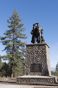
| 31 | Donner Camp Sites |
 |
(#66000218) |
Truckee 39°19′12″N 120°14′30″W / 39.32°N 120.241667°W |
Nevada | This site has a museum and monument dedicated to the Donner Party. They were a group of pioneers who got stuck in the snow during the winter of 1846–1847 and struggled to survive. |
| 32 | Drakes Bay Historic and Archeological District |
 |
(#12001006) |
Drakes Bay 38°02′03″N 122°56′27″W / 38.034223°N 122.940800°W |
Marin | This is believed to be where Francis Drake landed in 1579 and Sebastian Rodriguez Cermeño in 1595. It's important for understanding early meetings between Native Americans and European explorers. |
| 33 | Eames House (Case Study House #8) |
 |
(#06000978) |
Pacific Palisades 34°01′47″N 118°31′10″W / 34.029722°N 118.519444°W |
Los Angeles | This house was built in 1949 by the famous design team Charles and Ray Eames. It's also known as Case Study House No. 8. |
| 34 | Elmshaven (Ellen White House) |
.jpg) |
(#93001609) |
St. Helena 38°32′06″N 122°28′41″W / 38.5351240606°N 122.477946296°W |
Napa | Ellen Gould White lived and worked here from 1900 until 1915. She was a key figure in the rise of the Seventh-day Adventist Church. |
| 35 | Estudillo House |
.jpg) |
(#70000143) |
San Diego 32°45′15″N 117°11′49″W / 32.754196°N 117.197075°W |
San Diego | This adobe house was built in 1827 and was considered one of the most beautiful homes in Mexican California. |
| 36 | Eureka (double-ended ferry) |
.JPG) |
(#73000229) |
San Francisco 37°48′27″N 122°25′17″W / 37.8074567997°N 122.42131233°W |
San Francisco | The Eureka is a paddle steamboat built in 1890. It's now preserved at the San Francisco Maritime National Historical Park. |
| 37 | USCGC Fir |
 |
(#92001880) |
Stockton 38°09′00″N 121°40′59″W / 38.149918°N 121.683176°W |
San Joaquin | The USCGC Fir is a 174-foot U.S. Coast Guard ship that used to tend lighthouses. It is no longer in service. |
| 38 | First Church of Christ, Scientist |
 |
(#77000283) |
Berkeley 37°51′56″N 122°15′20″W / 37.865504°N 122.255642°W |
Alameda | This church was designed by architect Bernard Ralph Maybeck. |
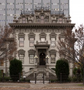
| 39 | James C. Flood Mansion |
 |
(#66000230) |
San Francisco 37°47′31″N 122°24′39″W / 37.791854°N 122.410818°W |
San Francisco | This mansion belonged to James C. Flood, a wealthy silver businessman from the 1800s. It was one of the few buildings on Nob Hill to survive the 1906 San Francisco earthquake and fire. |
| 40 | Folsom Powerhouse |
 |
(#73000426) |
Folsom 38°40′50″N 121°10′32″W / 38.680556°N 121.175556°W |
Sacramento | Built in the late 1800s, this powerhouse first sent electricity to Sacramento in 1895. It operated until 1952. |
| 41 | Fort Ross |
.jpg) |
(#66000239) |
Fort Ross 38°30′45″N 123°14′34″W / 38.5124247055°N 123.242708003°W |
Sonoma | Fort Ross was a busy Russian settlement from 1812 to 1841. It was started by Ivan Kuskov of the Russian-American Company. |
| 42 | Fresno Sanitary Landfill |
 |
(#01001050) |
Fresno 36°42′00″N 119°49′47″W / 36.7°N 119.829722°W |
Fresno | This landfill opened in 1937 and was the first modern landfill in the United States. It became a model for other landfills across the country. |
| 43 | David B. Gamble House |
 |
(#71000155) |
Pasadena 34°09′06″N 118°09′37″W / 34.151669°N 118.160364°W |
Los Angeles | The Gamble House is a masterpiece of Arts and Crafts design. It shows influences from Japanese art and the open spaces of California. |
| 44 | González House |
 |
(#70000149) |
Santa Barbara 34°25′27″N 119°41′45″W / 34.424217°N 119.695856°W |
Santa Barbara | Built around 1825 by Don Rafael Gonzales, this adobe house is a typical example of homes from the Mexican era. Its adobe walls are very thick, at least two feet! |
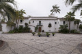
| 45 | Guajome Ranch House |
 |
(#70000145) |
Vista 33°14′00″N 117°15′14″W / 33.233375°N 117.253969°W |
San Diego | This is a Spanish Colonial hacienda (a large estate) with two courtyards. |
| 46 | Gunther Island Site 67 |
 |
(#66000208) |
Eureka 40°48′36″N 124°10′19″W / 40.809999°N 124.1719444°W |
Humboldt | This archaeological site on Indian Island is important for understanding the ancient Wiyot people. It also marks the site of the 1860 Wiyot Massacre. |
| 47 | Hale Solar Observatory |
 |
(#86000103) |
Pasadena 34°07′59″N 118°07′19″W / 34.132974°N 118.121818°W |
Los Angeles | This was the laboratory of George Ellery Hale, who invented the spectroheliograph. With it, he made important discoveries about the sun's magnetic fields. |
| 48 | Hanna-Honeycomb House |
 |
(#78000780) |
Palo Alto 37°24′58″N 122°09′51″W / 37.416131°N 122.164135°W |
Santa Clara | Located on the Stanford University campus, this was Frank Lloyd Wright's first project in the San Francisco area. It was also his first time working with non-rectangular shapes in a building. |
| 49 | Harada House |
 |
(#77000325) |
Riverside 33°59′07″N 117°22′09″W / 33.985167°N 117.369250°W |
Riverside | This property was part of a legal case between 1916 and 1918. The case tested the rights of children of Japanese immigrants under an alien land law. |
| 50 | Hearst San Simeon Estate |
 |
(#72000253) |
San Simeon 35°41′06″N 121°10′04″W / 35.684999999999995°N 121.16777777777779°W |
San Luis Obispo | This amazing estate was built by newspaper owner William Randolph Hearst. It's now open for public tours and was formally named "La Cuesta Encantada" by Hearst. |
| 51 | Hercules (tug) |
.JPG) |
(#75000225) |
San Francisco 37°48′30″N 122°25′16″W / 37.8084470841°N 122.421077397°W |
San Francisco | The Hercules is a 1907 steam tug that is now a museum ship at the San Francisco Maritime National Historical Park. |
| 52 | Lou Henry and Herbert Hoover House |
 |
(#78000786) |
Palo Alto 37°25′04″N 122°10′09″W / 37.417719°N 122.169060°W |
Santa Clara | This house was designed by Lou Henry Hoover, wife of President Herbert Hoover. The Hoovers lived here before and after his time as president. It's now the official home of the president of Stanford University. |
| 53 | USS Hornet (CVS-12) (aircraft carrier) |
.jpg) |
(#91002065) |
Alameda 37°46′22″N 122°18′10″W / 37.77272°N 122.302895°W |
Alameda | The USS Hornet is an Essex class aircraft carrier that was used in World War II and the Vietnam War. It also helped recover the Apollo Astronauts when they returned from the Moon. |
| 54 | Hotel del Coronado |
 |
(#71000181) |
Coronado 32°40′51″N 117°10′36″W / 32.680895°N 117.176599°W |
San Diego | This Victorian building is the largest beach resort on the North American Pacific Coast. It's a famous symbol of San Diego. |
| 55 | Edwin Hubble House |
.jpg) |
(#76000494) |
San Marino 34°07′24″N 118°07′17″W / 34.123261°N 118.121400°W |
Los Angeles | This was the home of famous astronomer Edwin Hubble from 1925 until he passed away in 1953. |
| 56 | Jeremiah O'Brien (Liberty ship) |
.JPG) |
(#78003405) |
San Francisco 37°48′23″N 122°25′43″W / 37.8063206324°N 122.428591541°W |
San Francisco | The SS Jeremiah O'Brien is a rare Liberty ship that was part of the huge fleet that went to Normandy on D-Day in 1944. |
| 57 | Knight's Ferry Bridge |
 |
(#12001014) |
Knights Ferry 37°49′10″N 120°39′49″W / 37.819497°N 120.663618°W |
Stanislaus | This covered bridge from 1863 is one of the best-preserved examples of the Howe truss design. |
| 58 | La Purisima Mission |
 |
(#70000147) |
Lompoc 34°40′18″N 120°25′21″W / 34.671803°N 120.422457°W |
Santa Barbara | Now a historical park, this is the only "complete" mission complex in California, showing what a mission looked like in its entirety. |
| 59 | Lake Merritt Wild Duck Refuge |
 |
(#66000205) |
Oakland 37°48′14″N 122°15′33″W / 37.8039°N 122.2591°W |
Alameda | Now known as Lake Merritt Park, this was the first official wildlife refuge in the United States, created in 1870. |
| 60 | Lane Victory (victory ship) |
 |
(#90002222) |
San Pedro 33°42′52″N 118°16′29″W / 33.714444°N 118.274722°W |
Los Angeles | The Lane Victory is a rare example of a Victory Ship. It's now a working museum ship that offers public cruises. |
| 61 | Larkin House |
 |
(#66000215) |
Monterey 36°35′56″N 121°53′44″W / 36.598893°N 121.895642°W |
Monterey | This house, part of the Monterey State Historic Park, mixes Spanish building styles with New England features. This created the unique Monterey Colonial architecture style. |
| 62 | Las Flores Adobe |
 |
(#68000021) |
Camp Pendleton 33°18′00″N 117°27′40″W / 33.299949°N 117.461067°W |
San Diego | This adobe building was a halfway stop between two missions. It's now part of a Boy Scout camp inside Camp Pendleton. |
| 63 | Leconte Memorial Lodge |
 |
(#77000148) |
Yosemite National Park 37°44′18″N 119°34′42″W / 37.7383029633°N 119.578421199°W |
Mariposa | The Sierra Club built this lodge in 1903 to honor Joseph LeConte, one of its founders. It serves as a museum and library today. |
| 64 | Lightship WAL-605, Relief |
.jpg) |
(#89002462) |
Oakland 37°47′44″N 122°16′50″W / 37.795689°N 122.280592°W |
Alameda | The Relief is a lightvessel (a ship that acts as a lighthouse) now located in Oakland. |
| 65 | Little Tokyo Historic District |
,_-Little_Tokyo-_--_2012_--_4908.jpg) |
(#86001479) |
Los Angeles 34°03′02″N 118°14′22″W / 34.050556°N 118.239444°W |
Los Angeles | This is an important Japanese American neighborhood in downtown Los Angeles. It's one of only three official Japantowns in the United States. |
| 66 | Locke Historic District |
 |
(#71000174) |
Locke 38°15′02″N 121°30′35″W / 38.25055555555556°N 121.50972222222222°W |
Sacramento | Locke is the largest remaining example of a historic rural Chinese American community. It was built in 1915. |
| 67 | Jack London Ranch |
 |
(#66000240) |
Glen Ellen 38°21′02″N 122°32′35″W / 38.350556°N 122.543056°W |
Sonoma | This was the home of famous writer Jack London from 1905 until he passed away. |
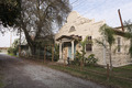
| 68 | Los Alamos Ranch House |
 |
(#70000148) |
Los Alamos 34°45′10″N 120°19′20″W / 34.752909°N 120.322319°W |
Santa Barbara | This is a good example of a single-story adobe ranch house from the Mexican era. It was a common stop for travelers on the El Camino Real. |
| 69 | Los Angeles Memorial Coliseum |
 |
(#84003866) |
Los Angeles 34°00′50″N 118°17′16″W / 34.014°N 118.28778°W |
Los Angeles | This is the only stadium in the world to have hosted the Summer Olympic Games (in 1932 and 1984), the World Series (1959), and the Super Bowl (1967 and 1973). |
| 70 | Los Cerritos Ranch House |
.jpg) |
(#70000135) |
Long Beach 33°50′11″N 118°11′40″W / 33.836392°N 118.194523°W |
Los Angeles | This was the largest adobe home built in Southern California during the Mexican era. |
| 71 | Lower Klamath National Wildlife Refuge |
 |
(#66000238) |
Dorris, CA and Klamath Falls, OR 41°58′00″N 121°46′00″W / 41.966667°N 121.76667°W |
Siskiyou, CA and Klamath, OR | This national wildlife refuge, created in 1908, was the first large area of public land set aside to protect wildlife. |
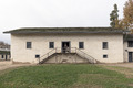
| 72 | Manzanar War Relocation Center |
 |
(#76000484) |
Independence 36°43′41″N 118°09′16″W / 36.7280556°N 118.1544445°W |
Inyo | Manzanar was the most well-known American camp where over 11,000 Japanese Americans were held during World War II. |
| 73 | Mare Island Naval Shipyard |
_at_the_Mare_Island_Naval_Shipyard,_California_(USA),_on_10_April_1945_(NH_98906).jpg) |
(#75002103) |
Vallejo 38°06′N 122°16′W / 38.1°N 122.27°W |
Solano | This was the first U.S. naval facility on the West Coast. It built and supported ships during WWII and for nuclear submarines. |
| 74 | Marin County Civic Center |
 |
(#91002055) |
San Rafael 37°59′52″N 122°31′50″W / 37.99778°N 122.530555°W |
Marin | This was the last major project designed by Frank Lloyd Wright. Its unique architecture has appeared in several films. |
| 75 | Mendocino Woodlands Recreational Demonstration Area |
 |
(#97001262) |
Mendocino 39°19′43″N 123°41′54″W / 39.3286111°N 123.698333°W |
Mendocino | This is the only Recreational Demonstration Area built by the Civilian Conservation Corps that has been used as a campground continuously. It's now Mendocino Woodlands State Park. |
| 76 | Mission Beach Roller Coaster |
 |
(#78000753) |
San Diego 32°46′12″N 117°15′00″W / 32.7699345629°N 117.250059665°W |
San Diego | This roller coaster, built in 1925, is one of only two wooden seaside roller coasters left on the West Coast. It was saved from being torn down and is still working today! |
| 77 | Mission Inn |
 |
(#71000173) |
Riverside 33°58′54″N 117°22′18″W / 33.9816175011°N 117.371665653°W |
Riverside | This hotel has become the largest example of Mission Revival Style architecture. It features shops, a chapel, and beautiful Tiffany windows. |
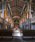
| 78 | Mission San Miguel Arcángel |
 |
(#71000191) |
San Miguel 35°44′41″N 120°41′53″W / 35.744722°N 120.698056°W |
San Luis Obispo | The 16th California Mission church is still well-preserved and used today. It has beautiful murals inside by Esteban Munrás. |
| 79 | Mission Santa Inés |
 |
(#99000630) |
Solvang 34°35′40″N 120°08′12″W / 34.594454°N 120.136657°W |
Santa Barbara | The 19th California Mission church was the site of an Indian revolt in 1824. It has been restored and is still a working church today. |
| 80 | Modjeska House |
 |
(#72000244) |
Modjeska 33°42′59″N 117°37′26″W / 33.7163426263°N 117.623823831°W |
Orange | This house, designed by Stanford White, was the home of Helena Modjeska, a Polish actress, from 1888 to 1906. |
| 81 | Monterey Old Town Historic District |
 |
(#70000137) |
Monterey 36°35′59″N 121°53′37″W / 36.599722°N 121.893611°W |
Monterey | Also known as Monterey State Historic Park, this district includes California's First Theatre and the Monterey Customs House, where the American flag was first raised over California. |
| 82 | John Muir House |
 |
(#66000083) |
Martinez 37°59′30″N 122°07′50″W / 37.991679°N 122.130511°W |
Contra Costa | John Muir, a famous naturalist, lived here from 1890 until his death. During this time, he helped found the Sierra Club and laid the groundwork for the National Park Service. |
| 83 | Neutra Studio and Residences (VDL Research House) |
 |
(#100000831) |
Los Angeles 34°05′54″N 118°15′38″W / 34.098453°N 118.260456°W |
Los Angeles | This was the home of architect Richard Neutra. He and his son Dion designed it using new ideas in modern architecture. |
| 84 | New Almaden |
 |
(#66000236) |
San Jose 37°10′48″N 121°50′08″W / 37.18°N 121.835556°W |
Santa Clara | Also known as Senador, this was one of the oldest and most productive mercury mines in the United States. It was important for the California Gold Rush. It's now part of Almaden Quicksilver County Park. |
| 85 | Richard M. Nixon Birthplace |
.jpg) |
(#71000171) |
Yorba Linda 33°53′19″N 117°49′08″W / 33.888611°N 117.818759°W |
Orange | This is the birthplace and childhood home of President Richard Milhous Nixon. It's now part of the Richard Nixon Presidential Library and Museum. |
| 86 | Frank Norris Cabin |
.jpg) |
(#66000235) |
Gilroy 37°02′11″N 121°42′45″W / 37.036389°N 121.7125°W |
Santa Clara | Also known as Redwood Retreat, this was the home of author Frank Norris during the last year of his life. |
| 87 | Nuestra Señora Reina de la Paz |
.jpg) |
(#11000576) |
Keene 35°13′24″N 118°33′49″W / 35.223413°N 118.563616°W |
Kern | This was the main office for the National Farm Workers Federation. It's now the Cesar Chavez National Monument and includes the grave of co-founder César Chávez. |
| 88 | Oak Grove Butterfield Stage Station |
 |
(#66000222) |
Warner Springs 33°23′23″N 116°47′39″W / 33.389728°N 116.794097°W |
San Diego | This is the only remaining station house from the Butterfield Overland Mail stagecoach line. |
| 89 | Old Customhouse |
 |
(#66000217) |
Monterey 36°35′46″N 121°53′31″W / 36.5961971882°N 121.892068798°W |
Monterey | This adobe building from 1827 is the oldest public building in California. It's where the American Flag was raised, making California part of the United States. It's now a museum. |
| 90 | Old Mission Dam |
 |
(#66000225) |
San Diego 32°50′17″N 117°02′32″W / 32.8381927311°N 117.042314031°W |
San Diego | This dam was the first major irrigation project on the Pacific coast. It provided water for the Mission San Diego de Alcalá. It's now part of Mission Trails Regional Park. |
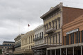
| 91 | Old Sacramento Historic District |
 |
(#66000219) |
Sacramento 38°34′58″N 121°30′12″W / 38.582778°N 121.503333°W |
Sacramento | This historic district grew after the California Gold Rush. It includes other important landmarks like the Pony Express Terminal and the Big Four House. |
| 92 | Old Scripps Building |
 |
(#77000330) |
La Jolla 32°51′52″N 117°15′09″W / 32.864446°N 117.252395°W |
San Diego | This was the first building of the Scripps Institution of Oceanography, the oldest oceanographic institute in the United States. It helped start what is now the University of California, San Diego. |
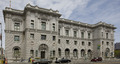
| 93 | Old United States Mint |
_3.JPG) |
(#66000231) |
San Francisco 37°46′58″N 122°24′23″W / 37.782727°N 122.406479°W |
San Francisco | Built in 1874 to handle the gold from the California Gold Rush, this building is known as The Granite Lady. It survived the great 1906 San Francisco earthquake and was used until 1937. |
| 94 | Our Lady of Guadalupe Mission Chapel |
 |
(#100000836) |
San Jose 37°21′09″N 121°50′41″W / 37.352579°N 121.844681°W |
Santa Clara | Now called McDonnell Hall, this building was important in the life of activist Cesar Chavez. |
| 95 | USS Pampanito (submarine) |
.JPG) |
(#86000089) |
San Francisco 37°48′31″N 122°24′56″W / 37.8086004153°N 122.415623276°W |
San Francisco | The USS Pampanito is a Balao|submarine|1 that served in World War II. It's now a museum ship with many working parts, like its periscopes. |
| 96 | Paramount Theatre |
 |
(#73000395) |
Oakland 37°48′34″N 122°16′05″W / 37.809457°N 122.267984°W |
Alameda | This was the largest theater on the West Coast when it was built. It's known for its Art Deco style and is home to the Oakland East Bay Symphony and Oakland Ballet. |
| 97 | Parsons Memorial Lodge |
 |
(#79000283) |
Yosemite National Park 37°52′36″N 119°22′00″W / 37.8766108572°N 119.366616789°W |
Tuolumne | This strong stone building was the first stone structure in a National Park. It was built by the Sierra Club and still stands today. |
| 98 | Petaluma Adobe |
 |
(#70000151) |
Petaluma 38°15′20″N 122°35′04″W / 38.25547°N 122.58451°W |
Sonoma | This adobe building is the largest example of Monterey Colonial architecture in the United States. It was the ranch house of General Mariano Guadalupe Vallejo. It's now the main part of Petaluma Adobe State Historic Park. |
| 99 | Pioneer Deep Space Station |
 |
(#85002813) |
Fort Irwin 35°23′15″N 116°51′22″W / 35.3874891024°N 116.856198162°W |
San Bernardino | This radio telescope (DSS 11) started operating in 1958. It was the beginning of NASA's Deep Space Network for tracking spacecraft far out in space. |
| 100 | Point Reyes Lifeboat Station |
 |
(#85002756) |
Point Reyes 37°59′38″N 122°58′26″W / 37.993889°N 122.973889°W |
Marin | This is the last remaining USLS station that launched lifeboats from rails, a common method on the Pacific coast. It's now part of the Point Reyes National Seashore. |
| 101 | Pond Farm Pottery Historic District |
 |
(#100009799) |
17000 Armstrong Woods Road 38°33′08″N 123°00′00″W / 38.552171°N 122.999991°W |
Sonoma County, California | This site was named a National Historic Landmark in 2023. |
| 102 | Pony Express Terminal |
.jpg) |
(#66000220) |
Sacramento 38°34′58″N 121°30′15″W / 38.582898°N 121.504248°W |
Sacramento | This bank building was the Western end of the Pony Express. It also served as the first home of the Supreme Court of California. It's now part of the Old Sacramento State Historic Park. |
| 103 | Potomac (Presidential yacht) |
 |
(#87000068) |
Oakland 37°47′37″N 122°16′44″W / 37.793512671°N 122.278992912°W |
Alameda | This ship was Franklin Delano Roosevelt’s presidential yacht from 1936 until 1945. It's one of only three presidential yachts still existing. It's now a museum ship. |
| 104 | Presidio of San Francisco |
.jpg) |
(#66000232) |
San Francisco 37°48′00″N 122°28′00″W / 37.8°N 122.466667°W |
San Francisco | This was a fortified military base from 1776 to 1995, used by Spain, Mexico, and the United States. It's now part of the Golden Gate National Recreation Area. |
| 105 | Ralph J. Scott (fireboat) |
.JPG) |
(#89001430) |
San Pedro 33°44′29″N 118°16′44″W / 33.741292°N 118.278953°W |
Los Angeles | This fireboat served the LAFD from 1925 until 2003. It could pump a huge amount of water! It's now near the Los Angeles Maritime Museum. |
| 106 | William C. Ralston Home |
 |
(#66000234) |
Belmont 37°31′03″N 122°17′10″W / 37.5175°N 122.286111°W |
San Mateo | This was the home of William Chapman Ralston, a San Francisco businessman who founded the Bank of California. It's now part of Notre Dame de Namur University. |
| 107 | Rancho Camulos |
 |
(#96001137) |
Piru 34°24′20″N 118°45′24″W / 34.40565°N 118.756667°W |
Ventura | This was the home of Ygnacio del Valle, an important figure in Los Angeles. The ranch was likely the setting for the famous 1884 novel Ramona, which helped people learn about the Californio way of life. It's now a museum. |
| 108 | Rangers' Club |
.jpg) |
(#87001414) |
Yosemite National Park 37°44′44″N 119°35′12″W / 37.7454635709°N 119.586783467°W |
Mariposa | Stephen Tyng Mather, the first director of the National Park Service, personally gave this building to house the new park rangers. Its rustic style influenced all National Park buildings until WWII. |
| 109 | Rogers Dry Lake |
 |
(#85002816) |
Edwards Air Force Base 34°57′00″N 117°52′00″W / 34.95°N 117.86666666666666°W |
Kern and San Bernardino | This dry lakebed at Edwards Air Force Base has the world's largest compass rose and the longest runway (7.2 miles). It's also an alternate landing site for the Space Shuttle. |
| 110 | Room 307, Gilman Hall, University of California |
 |
(#66000203) |
Berkeley 37°52′15″N 122°15′18″W / 37.8708°N 122.2550°W |
Alameda | In Room 307 of Gilman Hall at UCB, Glenn T. Seaborg and his team discovered plutonium as a new element on February 23, 1941. |
| 111 | Rose Bowl |
 |
(#87000755) |
Pasadena 34°09′34″N 118°10′00″W / 34.1595343932°N 118.166774324°W |
Los Angeles | This stadium is the home field for the UCLA Bruins college football team and hosts the yearly Rose Bowl Game. It also hosted events for the 1932 and 1984 Summer Olympics. |
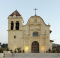
| 112 | Royal Presidio Chapel |
 |
(#66000216) |
Monterey 36°35′45″N 121°53′25″W / 36.595847°N 121.890299°W |
Monterey | This cathedral is the oldest continuously operating church parish and the oldest stone building in California. It's also one of the two oldest cathedrals in the United States. |
| 113 | San Diego Mission Church |
 |
(#70000144) |
San Diego 32°46′58″N 117°06′23″W / 32.7827680173°N 117.106253353°W |
San Diego | This was the very first Spanish Mission in Alta California. It marked the start of the El Camino Real (the Royal Road). |
| 114 | San Diego Presidio |
 |
(#66000226) |
San Diego 32°45′31″N 117°11′36″W / 32.758611°N 117.193333°W |
San Diego | This was the first fortified Spanish military base (presidio) in California. Along with the first mission, it helped Spain colonize California. The site is now in Presidio Park. |
| 115 | San Francisco Bay Discovery Site |
 |
(#68000022) |
Pacifica 37°36′11″N 122°27′17″W / 37.603056°N 122.454722°W |
San Mateo | On November 4, 1769, Spanish explorer Gaspar de Portolá saw San Francisco Bay for the first time from Sweeney Ridge. It's now part of the Golden Gate National Recreation Area. |
| 116 | San Francisco Cable Cars |
 |
(#66000233) |
San Francisco 37°47′44″N 122°24′27″W / 37.795556°N 122.4075°W |
San Francisco | These iconic cable cars are a famous symbol of San Francisco. It's the only remaining cable car system in the world that is still operated by hand. |
| 117 | San Francisco Civic Center |
 |
(#78000757) |
San Francisco 37°46′47″N 122°25′04″W / 37.77972222222222°N 122.41777777777779°W |
San Francisco | The United Nations Charter was signed here in 1945. This group of Beaux Arts buildings serves many purposes, including the Bill Graham Civic Auditorium. |
| 118 | San Francisco Port of Embarkation, U.S. Army |
 |
(#85002433) |
San Francisco 37°48′26″N 122°25′50″W / 37.80722222222222°N 122.43055555555556°W |
San Francisco | This fort was built for coastal defense during the American Civil War. It became the main transportation hub in the Pacific for the U.S. during World War I and World War II. |
| 119 | San Juan Bautista Plaza Historic District |
 |
(#69000038) |
San Juan Bautista 36°50′37″N 121°32′04″W / 36.8437377837°N 121.53455399°W |
San Benito | This district is a great example of a Spanish-Mexican colonial town plan, with buildings around a central plaza and mission church. It was featured in the Alfred Hitchcock film Vertigo. |
| 120 | San Luis Rey Mission Church |
 |
(#70000142) |
Oceanside 33°22′03″N 117°13′06″W / 33.3675°N 117.218333°W |
San Diego | This is California's most well-preserved Spanish Mission Complex. It is the third church built at this site. |
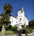
| 121 | Santa Barbara County Courthouse |
 |
(#81000177) |
Santa Barbara 34°25′28″N 119°42′09″W / 34.42435°N 119.702461°W |
Santa Barbara | This courthouse is known for its beautiful Spanish-Colonial Revival design, which inspired many other buildings. |
| 122 | Santa Barbara Mission |
 |
(#66000237) |
Santa Barbara 34°26′15″N 119°42′45″W / 34.437362°N 119.712634°W |
Santa Barbara | This is the only Spanish mission in California that has been continuously led by Franciscan Friars since it was founded. |
| 123 | Santa Cruz Looff Carousel and Roller Coaster |
 |
(#87000764) |
Santa Cruz 36°57′52″N 122°01′00″W / 36.964444444444446°N 122.01666666666667°W |
Santa Cruz | The Looff family made this carousel in 1911. Only five other complete Looff carousels are left in the United States. The 1924 Giant Dipper roller coaster is one of the oldest wooden seaside roller coasters on the West Coast. |
| 124 | Santa Monica Looff Hippodrome |
 |
(#87000766) |
Santa Monica 34°00′37″N 118°29′47″W / 34.010184°N 118.496368°W |
Los Angeles | The Looff family built this structure to house one of their carousels. It's a rare example of what was once a much larger amusement park. |
| 125 | Upton Sinclair House |
 |
(#71000153) |
Monrovia 34°09′43″N 118°00′04″W / 34.161969°N 118.001210°W |
Los Angeles | This was the home of American novelist Upton Sinclair between 1942 and 1966. He wrote most of his later books here. |
| 126 | Sonoma Plaza |
 |
(#75000489) |
Sonoma 38°17′04″N 122°27′27″W / 38.2844470556°N 122.457393148°W |
Sonoma | This is the largest plaza in California. It was the site of the Bear Flag Revolt in 1846, which led to the Mexican–American War. |
| 127 | Space Flight Operations Facility |
 |
(#85002814) |
Pasadena 34°11′58″N 118°10′25″W / 34.1993285017°N 118.173617161°W |
Los Angeles | This is the control room at Jet Propulsion Laboratory where all NASA missions to other planets and deep space are monitored. |
| 128 | Space Launch Complex 10 |
 |
(#86003511) |
Vandenberg Air Force Base 34°45′55″N 120°37′20″W / 34.765278°N 120.622222°W |
Santa Barbara | First built in 1958 to test missiles, this complex was used to launch space missions from 1963 to 1980. It's a rare, well-preserved example of space equipment from that time. |
| 129 | Leland Stanford House |
 |
(#71000178) |
Sacramento 38°34′36″N 121°29′52″W / 38.576528°N 121.497914°W |
Sacramento | This was the home of Leland Stanford, who was the Governor of California and a U.S. Senator. He was also a railroad tycoon and founded Stanford University. |
| 130 | Star of India (bark) |
 |
(#66000223) |
San Diego 32°42′51″N 117°10′22″W / 32.7142265105°N 117.172862915°W |
San Diego | The Star of India is a seaworthy iron-hulled museum ship in the San Diego Maritime Museum. It's the oldest ship that still sails regularly and the oldest iron-hulled merchant ship still floating. |
| 131 | Steedman Estate (Casa del Herrero) |
 |
(#87000002) |
Montecito 34°26′07″N 119°38′08″W / 34.43527777777778°N 119.63555555555556°W |
Santa Barbara | Designed by architect George Washington Smith, this 11-acre estate from the 1920s is considered one of the best examples of Spanish Colonial Revival architecture in the United States. |
| 132 | Sutter's Fort |
 |
(#66000221) |
Sacramento 38°34′14″N 121°28′12″W / 38.5704472774°N 121.470071911°W |
Sacramento | This 19th-century farming and trading colony was important for the Donner Party, the California Gold Rush, and the founding of Sacramento. It's now a state park. |
| 133 | Swedenborgian Church |
.jpg) |
(#04001154) |
San Francisco 37°47′25″N 122°26′45″W / 37.790229°N 122.445882°W |
San Francisco | This church is one of California's earliest pure Arts and Crafts buildings. It's still open today with almost no changes to its design. |
| 134 | Tao House |
|
(#71000137) |
Danville 37°49′33″N 122°01′39″W / 37.825961°N 122.02755°W |
Contra Costa | Eugene O'Neill, America's only Nobel Prize-winning playwright, lived here from 1937 to 1944. He wrote some of his most famous plays here, like Long Day's Journey Into Night. |
| 135 | The Forty Acres |
 |
(#08001090) |
Delano 35°45′48″N 119°17′15″W / 35.76325278°N 119.287497221°W |
Kern | This served as the first headquarters of the United Farm Workers, which was the first permanent union for farm workers in the United States. |
| 136 | Tule Lake Segregation Center |
 |
(#06000210) |
Newell 41°53′08″N 121°22′26″W / 41.88544°N 121.373768°W |
Modoc | This was the largest Japanese American internment camp, with the highest security. It stayed open even after World War II. |
| 137 | Twenty-Five-Foot Space Simulator |
 |
(#85002812) |
Pasadena 34°12′03″N 118°10′22″W / 34.2009587786°N 118.172880016°W |
Los Angeles | This 85-foot-high cylinder at the Jet Propulsion Laboratory is used to test spacecraft in conditions similar to space. Many famous spacecraft, like Mariner and Voyager, were tested here. |
| 138 | Unitary Plan Wind Tunnel |
 |
(#85002799) |
Moffett Field 37°24′56″N 122°03′35″W / 37.4156663073°N 122.059785401°W |
Santa Clara | This wind tunnel, built in the 1950s, allowed commercial and military aircraft, as well as the Space Shuttle, to be tested for how they move through the air. |
| 139 | United States Immigration Station, Angel Island |
.jpg) |
(#71000164) |
Tiburon 37°51′44″N 122°25′13″W / 37.862222°N 122.4202778°W |
Marin | Known as the "Ellis Island of the West," this station processed over 1 million Asian immigrants between 1910 and 1940. It's now part of Angel Island State Park. |
| 140 | United States Post Office and Court House (Court House for the Central District of California) |
 |
(#06000001) |
Los Angeles 34°03′18″N 118°14′33″W / 34.055053°N 118.242481°W |
Los Angeles | This courthouse was built in 1940 and shows the Art Moderne style of architecture. |
| 141 | United States Post Office and Court House (James R. Browning U.S. Court of Appeals) |
 |
(#71000188) |
San Francisco 37°46′46″N 122°24′40″W / 37.779404°N 122.411162°W |
San Francisco | This courthouse was built in 1905. It reflects the Beaux Arts style used in many federal buildings in the early 1900s. |
| 142 | Walker Pass |
 |
(#66000210) |
Onyx 35°39′47″N 118°01′37″W / 35.663056°N 118.026944°W |
Kern | Joseph Reddeford Walker mapped this mountain pass in 1834, learning about it from Native Americans. He later led the first wagon train of immigrants through it in 1846, which helped California grow. |
| 143 | Warner's Ranch |
 |
(#66000228) |
Warner Springs 33°14′19″N 116°39′03″W / 33.238611°N 116.650833°W |
San Diego | This ranch was the only trading post between New Mexico and Los Angeles. It became a stop on the Butterfield Overland Mail stagecoach line. It's now a hot springs resort. |
| 144 | Watts Towers |
 |
(#77000297) |
Los Angeles 33°56′13″N 118°14′26″W / 33.9369667128°N 118.240549404°W |
Los Angeles | These towers were built by Simon Rodia. They are an amazing example of unique, non-traditional art and architecture. |
| 145 | Wawona Hotel and Thomas Hill Studio |
.jpg) |
(#75000223) |
Yosemite National Park 37°32′11″N 119°39′13″W / 37.536389°N 119.653611°W |
Mariposa | Built in 1879 for tourists visiting the Mariposa Grove, this hotel is also where painter Thomas Hill worked later in his life. |
| 146 | Wayfarers Chapel |
 |
(#100009801) |
5755 Palos Verdes Dr. S 33°44′41″N 118°22′33″W / 33.744722°N 118.375833°W |
Los Angeles County, California | Designed by Lloyd Wright, this church is a well-preserved example of modern church architecture and landscaping from after World War II. |
| 147 | Well No. 4, Pico Canyon Oil Field |
 |
(#66000212) |
Stevenson Ranch 34°22′10″N 118°37′49″W / 34.369444°N 118.630278°W |
Los Angeles | Drilled in 1876, this was the first oil well in California that was successful for business. It produced 25 barrels of oil each day. |
| 148 | Yuma Crossing and Associated Sites |
 |
(#66000197) |
Winterhaven 32°43′45″N 114°36′55″W / 32.7292°N 114.6153°W |
Imperial | This area was a very important crossroads for travel and trade in early California and for the expansion of the United States westward. It has many historical sites, shared with Arizona. |
Former National Historic Landmarks
Here are a few sites that were once National Historic Landmarks in California but are not anymore.
| Landmark name | Image |
Date designated | Date moved or withdrawn |
Location | Description | |
|---|---|---|---|---|---|---|
| 1 | First Pacific Coast Salmon Cannery Site | April 6, 1964 | July 14, 2004 | Broderick, Yolo County 38°34′51″N 121°30′26″W / 38.5808401987°N 121.507276585°W |
The first salmon cannery on the Pacific Coast was started here in 1864. However, nothing from the original cannery remains today, and the area has changed a lot due to floods and a city park. So, its landmark status was removed in 2004. | |
| 2 | Fort Ross Chapel | 1969 | 1971 | Fort Ross, Sonoma County | The chapel at Fort Ross was a rare example of a log church built by the Russians. It lost its landmark status after a fire destroyed most of the building in 1970. A new version of the chapel now stands in its place. | |
| 3 | Rock Magnetics Laboratory | October 12, 1994 | March 8, 1999 | Menlo Park, San Mateo County | This was the site where scientists made important discoveries about geomagnetic reversals (when Earth's magnetic poles flip) and plate tectonics (how Earth's crust moves). The lab was in a temporary building that was torn down in the late 1990s. | |
| 4 | Wapama (steam schooner) | April 20, 1984 | February 27, 2015 | San Francisco | The Wapama was a 204-foot wooden schooner, the last of its kind that used to carry lumber along the Pacific coast. It was taken apart in 2013. |

.jpg)
Learn More About California's History
- California Point of Historical Interest
- California Register of Historical Resources
- Historic preservation
- History of California
- List of California Historical Landmarks
- List of California State Historic Parks
- National Register of Historic Places listings in California
- National Register of Historic Places

All content from Kiddle encyclopedia articles (including the article images and facts) can be freely used under Attribution-ShareAlike license, unless stated otherwise. Cite this article:
List of National Historic Landmarks in California Facts for Kids. Kiddle Encyclopedia.